| Please join us at the 23rd annual Black Diamond Fall Fundraiser Party Thursday Sept 15. Tickets are on sale now here, at the Black Diamond store & at REI. Special bonus raffle for online ticket purchasers! |
| Please join us at the 23rd annual Black Diamond Fall Fundraiser Party Thursday Sept 15. Tickets are on sale now here, at the Black Diamond store & at REI. Special bonus raffle for online ticket purchasers! |
| Advisory: Logan Area Mountains | Issued by Toby Weed for Monday - January 18, 2016 - 7:25am |
|---|

|
bottom line CONSIDERABLE (level 3): Dangerous avalanche conditions exist and careful snowpack evaluation, cautious routefinding and conservative decision-making will be essential in the backcountry today. Triggered avalanches are likely on recently drifted slopes steeper than about 30 degrees, and natural wind slab and/or wet avalanches are possible in some areas. Continue to avoid travel on or beneath steep drifted slopes. Avalanches could be triggered remotely, from a distance or even below!
|
 |
current conditions Dangerous avalanche conditions still exist today on drifted slopes in the backcountry, and you should continue to stay off of and out from under drifted slopes steeper than about 30 degrees. The temperature is a balmy 27 degrees and I'm reading one inch of new snow from overnight at the 8400' Tony Grove Snotel. There's now 61 inches of total snow, containing 95% of average water content for the date. The 9700' CSI Logan Peak weather station reports 22 degrees this morning and significantly increased southwest winds overnight, with current wind speeds averaging around 26 mph, and gusting into the mid forties.
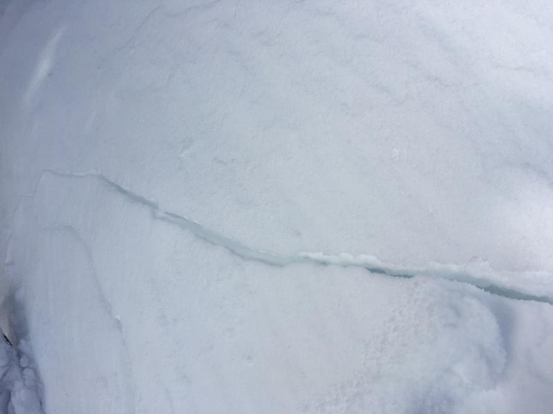
I triggered several fairly deep shooting cracks yesterday in drifted lower angle terrain. These are a sure sign of instability. (1-17-2015)
|
 |
recent activity
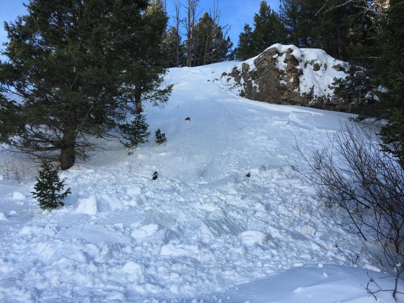
I don't know the story, but it occurred yesterday afternoon. Looks like skier (or rider) triggered as I could see both types of tracks entering this small avalanche just above the backside parking. Remember, the backside of Beaver Mt. is the backcountry. You need to carry and practice with a beacon, probe, and shovel, and practice good backcountry travel protocols by only exposing one person at a time to a steep slope and going with a group or at least a partner. (1-17-2015)
***To view our updated list of backcountry observations and avalanche activity from around Utah, go to our observations page
|
| type | aspect/elevation | characteristics |
|---|

|

|
LIKELIHOOD
 LIKELY
UNLIKELY
SIZE
 LARGE
SMALL
TREND
 INCREASING DANGER
SAME
DECREASING DANGER
|
|
description
Southwest winds intensified overnight, and drifting snow from westerly winds Saturday night built fresh drifts in deposition areas and added weight to existing wind slabs. Many of these were sensitive to human triggering yesterday, and more drifting is likely during accumulating snowfall today. Avoid recent drifts and/or stiffer wind slabs near ridge tops and in and around terrain features like gullies, sub-ridges, scoops, and rock outcroppings. Many wind slabs probably formed on weak faceted or feathery snow that was previously on the snow surface, which means the slabs could be reactive to our weight, and the older drifts may stay sensitive to human triggering for several days.
|
| type | aspect/elevation | characteristics |
|---|

|
|
LIKELIHOOD
LIKELY
UNLIKELY
SIZE
 LARGE
SMALL
TREND
INCREASING DANGER
SAME
DECREASING DANGER
|
|
description
Earlier in the week, we found widespread loose and very weak snow on the surface, and now a slab layer consisting of drifted new snow has accumulated on it. Triggered persistent slab avalanches are likely in some areas today, and last week's weak surface snow is now a buried persistent weak layer that could stay reactive for several days at least. Avalanches are possible on steep slopes with significant fresh and drifted accumulations even in sheltered terrain and at lower elevations. In some areas, the faceted snow in the basal layers of the snowpack may become reactivated by the recently added weight of drifted new snow. Dangerous and destructive avalanches involving old snow and failing on sugary faceted snow or depth hoar are possible today, especially in areas with shallow snow cover and poor snow structure. ***Pay close attention to signs of unstable snow like recent avalanches, whumpfing, and shooting cracks, and be willing to reevaluate your plans. In these conditions you could trigger avalanches remotely, from a distance or worse, from below!
|
| type | aspect/elevation | characteristics |
|---|

|
|
LIKELIHOOD
 LIKELY
UNLIKELY
SIZE
LARGE
SMALL
TREND
INCREASING DANGER
SAME
DECREASING DANGER
|
|
description
We noticed lots of rollers and a few loose wet avalanches at lower elevations in Logan Canyon yesterday. It's raining down low this morning, and I'm unsure how high (or low) the rain/snow line is. Wet avalanches are certainly possible today on steep lower elevation slopes with saturated fresh snow and more rain or a higher rain/snow line could cause dangerous conditions with significant natural activity possible. Today is not a good day for fishing in the Logan River or recreating at lower elevations below steep snow covered slopes.... |
 |
weather Expect snow in the mountains today, with a 8500' high temperature around 31 degrees and southwest wind in the 15 to 20 mph range. 3 to 7 inches of accumulation is expected. Snow is likely tonight before around 2300 hrs, with 1 or 2 more inches possible, temperatures will drop to around 18 degrees and west winds are expected to diminish a bit. It'll be mostly cloudy tomorrow with a high near 29 degrees and moderate southwest wind. The next wave of storminess will arrive Tuesday night, with west winds and 5 to 9 inches of accumulation possible. |
| general announcements Presenting our Avalanche Awareness Class in Logan beginning the January 21, with a full field day in the backcountry on Saturday January 23. Go HERE for more information and to sign up. The CROWBAR backcountry ski race will be Saturday January 30. More info at http://CrowbarSkiRace.org. Please submit snow and avalanche observations from your ventures in the backcountry HERE. You can call us at 801-524-5304 or email HERE, or include #utavy in your Instagram or Tweet us @UAClogan. To report avalanche activity in the Logan Area or to contact the local avalanche forecaster call me, Toby, at 435-757-7578. I'll update this advisory throughout the season on Monday, Wednesday, Friday, and Saturday mornings by about 7:30 This advisory is produced by the U.S.D.A. Forest Service, which is solely responsible for its content. It describes only general avalanche conditions and local variations always exist. |