| Please join us at the 23rd annual Black Diamond Fall Fundraiser Party Thursday Sept 15. Tickets are on sale now here, at the Black Diamond store & at REI. Special bonus raffle for online ticket purchasers! |
| Please join us at the 23rd annual Black Diamond Fall Fundraiser Party Thursday Sept 15. Tickets are on sale now here, at the Black Diamond store & at REI. Special bonus raffle for online ticket purchasers! |
| Advisory: Logan Area Mountains | Issued by Toby Weed for Sunday - January 17, 2016 - 7:21am |
|---|

|
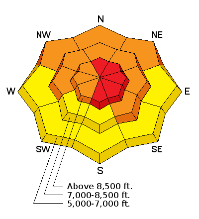
bottom line HIGH (level 4): Significant accumulations on slopes with preexisting weak snow and drifting from strong wind overnight created dangerous avalanche conditions in the backcountry. Triggered avalanches are likely on drifted slopes steeper than about 30 degrees, and natural avalanches are possible. We recommend that people avoid travel in avalanche terrain today. You should stay off of and out from under all steep drifted slopes and obvious or historic avalanche paths.
|
 |
avalanche warning THE FOREST SERVICE UTAH AVALANCHE CENTER IN SALT LAKE CITY HAS ISSUED A BACKCOUNTRY AVALANCHE WARNING. * TIMING...IN EFFECT FROM 6 AM THIS MORNING TO 6 AM MST MONDAY. * AFFECTED AREA...FOR THE MOUNTAINS OF NORTHERN UTAH NEAR LOGAN AND SOUTHEASTERN IDAHO INCLUDING THE BEAR RIVER RANGE. * AVALANCHE DANGER...THE AVALANCHE DANGER FOR THE WARNING AREA IS HIGH TODAY. * IMPACTS...RECENT SNOW COMBINED WITH WIND AND A PREEXISTING WEAKNESS IN THE SNOWPACK WILL CREATE WIDESPREAD AREAS OF UNSTABLE SNOW. BOTH HUMAN TRIGGERED AND NATURAL AVALANCHES ARE LIKELY. STAY OFF OF AND OUT FROM UNDER SLOPES STEEPER THAN 30 DEGREES. BACKCOUNTRY TRAVELERS SHOULD CONSULT WWW.UTAHAVALANCHECENTER.ORG OR CALL 1-888-999-4019 FOR MORE DETAILED INFORMATION. THIS WARNING DOES NOT APPLY TO SKI AREAS WHERE AVALANCHE HAZARD REDUCTION MEASURES ARE PERFORMED. |
 |
current conditions Very dangerous avalanche conditions exist today on drifted upper elevation slopes in the backcountry, and you should avoid travel in avalanche terrain. I'm hoping for a little clearing today so we can see evidence of last night's likely natural activity, but the plan is to stay off of and out from under drifted slopes steeper than about 30 degrees. The temperature is 22 degrees and I'm reading about 9 inches of new snow containing an even inch of water from yesterday and overnight at the 8400' Tony Grove Snotel. The station reports a gain of almost 2-and-a-half inches of snow water equivalent since Thursday morning. There's now 62 inches of total snow, containing 96% of average water content for the date. The 9700' CSI Logan Peak weather station reports 15 degrees this morning and diminishing northwest winds overnight. Looks like it was a bit windier last night at the UDOT Hwy 89 Summit, which reported 40 mph average wind speeds and a gust of 53 mph out of the west-northwest.
|
 |
recent activity
***To view our updated list of backcountry observations and avalanche activity from around Utah, go to our observations page
|
| type | aspect/elevation | characteristics |
|---|

|
|
LIKELIHOOD
 LIKELY
UNLIKELY
SIZE
 LARGE
SMALL
TREND
 INCREASING DANGER
SAME
DECREASING DANGER
|
|
description
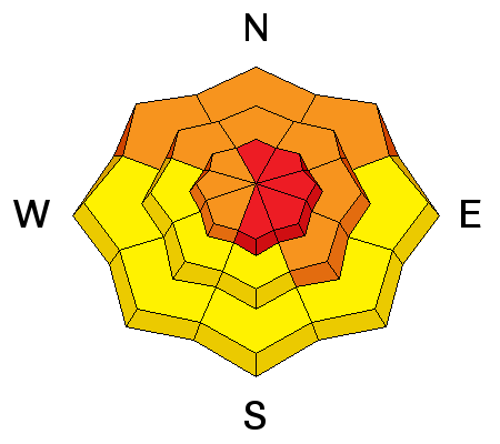
Drifting snow from westerly winds at upper elevations last night built fresh drifts in deposition areas and added weight to existing wind slabs. Avoid recent drifts and/or stiffer wind slabs near ridge tops and in and around terrain features like gullies, sub-ridges, scoops, and rock outcroppings. Many wind slabs probably formed on weak faceted or feathery snow that was previously on the snow surface, which means the slabs could be reactive to our weight, and the older drifts may stay sensitive to human triggering for several days.
Wednesday's hard wind slabs rested on weak surface snow, and they were still sensitive to our weight. Hard slabs have a nasty tendency to allow you to get out on them before releasing. Although these wind slabs were pretty small, the hardness makes them less manageable, and more dangerous wind slab conditions exist this weekend in drifted upper elevation areas. (1-13-2016)
|
| type | aspect/elevation | characteristics |
|---|

|
|
LIKELIHOOD
 LIKELY
UNLIKELY
SIZE
LARGE
SMALL
TREND
INCREASING DANGER
SAME
DECREASING DANGER
|
|
description
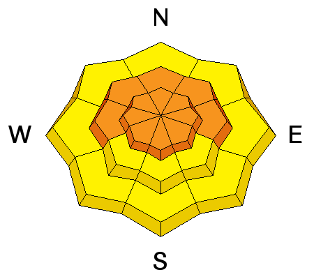
Earlier in the week, we found widespread loose and very weak snow on the surface, and now a slab layer consisting of drifted new snow has accumulated on it. Triggered storm slab avalanches are likely in some areas today, and significant soft slab avalanches failing within the new or recently fallen snow are also possible. Avalanches are possible on steep slopes with significant fresh accumulations even in sheltered terrain and at lower elevations.
|
| type | aspect/elevation | characteristics |
|---|

|

|
LIKELIHOOD
LIKELY
UNLIKELY
SIZE
 LARGE
SMALL
TREND
INCREASING DANGER
SAME
DECREASING DANGER
|
|
description
Dangerous and destructive avalanches involving old snow and failing on sugary faceted snow or depth hoar in the basal layers of the snowpack are possible today in areas with shallow snow cover and poor snow structure... |
 |
weather STATE WEATHER SYNOPSIS...A SERIES OF PACIFIC STORM SYSTEMS WILL MOVE ACROSS THE REGION THROUGH THE MIDDLE OF THE UPCOMING WEEK. HIGH PRESSURE ALOFT WILL DOMINATE THE WEATHER PATTERN OVER THE GREAT BASIN LATE IN THE WEEK. |
| general announcements Presenting our Avalanche Awareness Class in Logan beginning the January 21, with a full field day in the backcountry on Saturday January 23. Go HERE for more information and to sign up. The CROWBAR backcountry ski race will be Saturday January 30. More info at http://CrowbarSkiRace.org. Please submit snow and avalanche observations from your ventures in the backcountry HERE. You can call us at 801-524-5304 or email HERE, or include #utavy in your Instagram or Tweet us @UAClogan. To report avalanche activity in the Logan Area or to contact the local avalanche forecaster call me, Toby, at 435-757-7578. I'll update this advisory throughout the season on Monday, Wednesday, Friday, and Saturday mornings by about 7:30 This advisory is produced by the U.S.D.A. Forest Service, which is solely responsible for its content. It describes only general avalanche conditions and local variations always exist. |


