| Please join us at the 23rd annual Black Diamond Fall Fundraiser Party Thursday Sept 15. Tickets are on sale now here, at the Black Diamond store & at REI. Special bonus raffle for online ticket purchasers! |
| Please join us at the 23rd annual Black Diamond Fall Fundraiser Party Thursday Sept 15. Tickets are on sale now here, at the Black Diamond store & at REI. Special bonus raffle for online ticket purchasers! |
| Advisory: Logan Area Mountains | Issued by Toby Weed for Saturday - January 16, 2016 - 7:16am |
|---|

|
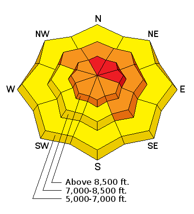
bottom line HIGH (level 4): Drifting from intensifying west winds could push the avalanche danger into the red at upper elevations in the backcountry later today. Dangerous conditions already exist, and natural avalanches will become increasingly likely today as drifted snow is rapidly deposited into avalanche starting zones. Avalanches are likely on drifted upper and mid elevation slopes steeper than about 30 degrees, and significant additional accumulations on slopes with preexisting weak snow will cause the avalanche danger to increase further and be more widespread this weekend. Stay off of and out from under steep drifted slopes at upper and mid elevations and avoid obvious or historic avalanche paths.
|
 |
avalanche watch THE FOREST SERVICE UTAH AVALANCHE CENTER IN SALT LAKE CITY HAS ISSUED A BACKCOUNTRY AVALANCHE WATCH. * TIMING...IN EFFECT FROM 6 AM MST THIS MORNING TO 6 AM MST SUNDAY * AFFECTED AREA...ALL THE MOUNTAINS OF NORTHERN AND CENTRAL UTAH AND SOUTHEASTERN IDAHO, TO INCLUDE THE WASATCH RANGE, THE BEAR RIVER RANGE, THE WESTERN UINTA RANGE, AND THE MANTI-SKYLINE PLATEAU. * AVALANCHE DANGER...THE AVALANCHE DANGER WILL BE HIGH TODAY. * IMPACTS...WIDESPREAD WEAK SNOW EXISTS UNDER NEW SNOW FROM THE LAST 48 HOURS. INCREASING WINDS WILL MAKE NATURAL AND HUMAN TRIGGERED AVALANCHES MORE LIKELY AS THE DAY PROGRESSES. THE AVALANCHE DANGER WILL BE RISING. BACKCOUNTRY TRAVELERS SHOULD CONSULT WWW.UTAHAVALANCHECENTER.ORG OR CALL 1-888-999-4019 FOR MORE DETAILED INFORMATION. THIS WATCH DOES NOT APPLY TO SKI AREAS WHERE AVALANCHE HAZARD REDUCTION MEASURES ARE PERFORMED. |
 |
current conditions The temperature is 17 degrees and I'm reading about 10 inches of new snow from yesterday and overnight at the 8400' Tony Grove Snotel. There's now 61 inches of total snow, containing 92% of average water content for the date. The 9700' CSI Logan Peak weather station reports 10 degrees this morning and fairly light west winds overnight.
|
 |
recent activity
***To view our updated list of backcountry observations and avalanche activity from around Utah, go to our observations page
|
| type | aspect/elevation | characteristics |
|---|

|
|
LIKELIHOOD
 LIKELY
UNLIKELY
SIZE
 LARGE
SMALL
TREND
 INCREASING DANGER
SAME
DECREASING DANGER
|
|
description
Drifting snow from westerly wind at upper elevations will easily build fresh drifts in deposition areas and add weight to existing wind slabs. Avoid recent drifts or stiffer wind slabs near ridge tops and in and around terrain features like gullies, sub-ridges, scoops, and rock outcroppings. Wind slabs may have formed on weak faceted or feathery snow that was previously on the snow surface, which means the slabs could be reactive to our weight, and the older drifts may stay sensitive to human triggering for a little while.
Wednesday's hard wind slabs rested on weak surface snow, and they were still sensitive to our weight. Hard slabs have a nasty tendency to allow you to get out on them before releasing. Although these wind slabs were pretty small, the hardness makes them less manageable, and more dangerous wind slab conditions likely exist this weekend in some drifted upper elevation areas. (1-13-2016)
|
| type | aspect/elevation | characteristics |
|---|

|
|
LIKELIHOOD
LIKELY
UNLIKELY
SIZE
LARGE
SMALL
TREND
INCREASING DANGER
SAME
DECREASING DANGER
|
|
description
The somewhat gradual accumulation on the widespread weak surface snow makes forecasting difficult, but I don't think there's enough of a new slab to create a problem in most areas yet. More accumulating snow today, this evening, and tonight could be enough to tip the scales in some areas. Before yesterday's snow, we found widespread loose and very weak snow on the surface, and as a slab consisting of heavy new snow stacks up on it, storm snow avalanches will become more likely. Significant avalanches failing within the new or recently fallen snow are also possible. More snow today or tonight could cause avalanches even in sheltered terrain and at lower elevations. The avalanche danger is likely to continue to rise and become more widespread in the backcountry this weekend.
|
 |
weather Snow is likely again today, with 8500' temperatures expected to be around 26 degrees, and intensifying west winds are expected to become fairly strong this afternoon and evening. 2 to 4 inches of accumulation is forecast by evening, with another 3 to 7 tonight. It'll be quite windy and wet overnight, with temperatures around 19 degrees and a good chance of natural avalanches. It'll be windy, cloudy, and a bit warmer tomorrow, with another bout of Pacific storminess to affect the zone on Martin Luther King Day... |
| general announcements Presenting our Avalanche Awareness Class in Logan beginning the January 21, with a full field day in the backcountry on Saturday January 23. Go HERE for more information and to sign up. The CROWBAR backcountry ski race will be Saturday January 30. More info at http://CrowbarSkiRace.org. Please submit snow and avalanche observations from your ventures in the backcountry HERE. You can call us at 801-524-5304 or email HERE, or include #utavy in your Instagram or Tweet us @UAClogan. To report avalanche activity in the Logan Area or to contact the local avalanche forecaster call me, Toby, at 435-757-7578. I'll update this advisory throughout the season on Monday, Wednesday, Friday, and Saturday mornings by about 7:30 This advisory is produced by the U.S.D.A. Forest Service, which is solely responsible for its content. It describes only general avalanche conditions and local variations always exist. |


