| Please join us at the 23rd annual Black Diamond Fall Fundraiser Party Thursday Sept 15. Tickets are on sale now here, at the Black Diamond store & at REI. Special bonus raffle for online ticket purchasers! |
| Please join us at the 23rd annual Black Diamond Fall Fundraiser Party Thursday Sept 15. Tickets are on sale now here, at the Black Diamond store & at REI. Special bonus raffle for online ticket purchasers! |
| Advisory: Logan Area Mountains | Issued by Toby Weed for Friday - January 15, 2016 - 7:14am |
|---|

|
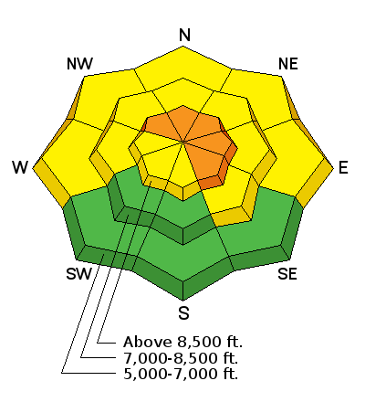
bottom line CONSIDERABLE (level 3): You are likely to trigger wind slab avalanches in the backcountry on drifted upper elevation slopes steeper than about 30 degrees. Significant accumulations on slopes with preexisting weak surface snow may cause avalanche danger to increase and be more widespread this weekend. Evaluate the snow and terrain carefully, make conservative decisions, and avoid steep drifted slopes at upper elevations.
|
 |
current conditions The temperature is 18 degrees and I'm reading about 7 inches of new snow from yesterday and overnight at the 8400' Tony Grove Snotel. There's now 52 inches of total snow, containing 89% of average water content for the date. The 9700' CSI Logan Peak weather station reports 12 degrees and somewhat enhanced southwest winds overnight, currently averaging in the mid teens.
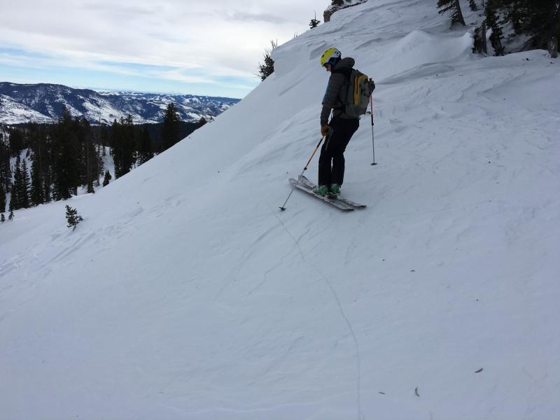
Shooting cracks like this one in a hard wind slab indicate unstable conditions. Stout wind slabs in the Mt Magog area Wednesday were failing pretty easily on weak surface snow. In this case, I could see flattened surface hoar feathers on the bed surface just below the crown, but weak small-grained sugary or faceted snow is also widespread in the Logan Zone. (1-13-2016)
|
 |
recent activity
***To view our updated list of backcountry observations and avalanche activity from around Utah, go to our observations page
|
| type | aspect/elevation | characteristics |
|---|

|

|
LIKELIHOOD
 LIKELY
UNLIKELY
SIZE
 LARGE
SMALL
TREND
 INCREASING DANGER
SAME
DECREASING DANGER
|
|
description
Drifting snow from westerly wind at upper elevations will easily build fresh drifts in deposition areas and add weight to existing wind slabs. Avoid stiff and perhaps hollow sounding wind slabs near ridge tops and in and around terrain features like gullies, sub-ridges, scoops, and rock outcroppings. Wind slabs may have formed on weak faceted or feathery snow that was previously on the snow surface, which means the slabs could be reactive to our weight, and the older drifts may stay sensitive to human triggering for a little while.
Wednesday's hard wind slabs rested on weak surface snow, and they were still sensitive to our weight. Hard slabs have a nasty tendency to allow you to get out on them before releasing. Although these wind slabs were pretty small, the hardness makes them less manageable, and more dangerous wind slab conditions likely exist this weekend in some drifted upper elevation areas. (1-13-2016)
|
| type | aspect/elevation | characteristics |
|---|

|
|
LIKELIHOOD
 LIKELY
UNLIKELY
SIZE
 LARGE
SMALL
TREND
INCREASING DANGER
SAME
DECREASING DANGER
|
|
description
The somewhat gradual accumulation on the widespread weak surface snow makes forecasting difficult, but I don't think there's enough of a new slab to create a problem in most areas yet. Before yesterday's snow, we found loose and very weak snow on the surface in many areas, and as a slab consisting of heavy new snow stacks up on it, storm snow avalanches may become more likely. More snow than expected today could cause soft slab avalanches to be possible even in sheltered terrain and at lower elevations. The avalanche danger is likely rise and become more widespread in the backcountry this weekend in areas where (and if) significant new or drifted snow accumulates on slopes with preexisting weak surface snow.
|
 |
weather Snow is likely again today, with 8500' temperatures expected to be around 23 degrees, and moderate west --> northwest winds are expected. Temperatures will drop into the lower teens tonight, and a west-northwest breeze will send wind chills below zero. More snow is expected, with 2 to 6 inches of accumulation forecast by tomorrow morning. Another wave of storminess will affect the zone tomorrow and tomorrow night with modest accumulations forecast to continue through the weekend and a bit stronger pulse to arrive on Martin Luther King Day... |
| general announcements Presenting our Avalanche Awareness Class in Logan beginning the January 21, with a full field day in the backcountry on Saturday January 23. Go HERE for more information and to sign up. The CROWBAR backcountry ski race will be Saturday January 30. More info at http://CrowbarSkiRace.org. Please submit snow and avalanche observations from your ventures in the backcountry HERE. You can call us at 801-524-5304 or email HERE, or include #utavy in your Instagram or Tweet us @UAClogan. To report avalanche activity in the Logan Area or to contact the local avalanche forecaster call me, Toby, at 435-757-7578. I'll update this advisory throughout the season on Monday, Wednesday, Friday, and Saturday mornings by about 7:30 This advisory is produced by the U.S.D.A. Forest Service, which is solely responsible for its content. It describes only general avalanche conditions and local variations always exist. |