| Please join us at the 23rd annual Black Diamond Fall Fundraiser Party Thursday Sept 15. Tickets are on sale now here, at the Black Diamond store & at REI. Special bonus raffle for online ticket purchasers! |
| Please join us at the 23rd annual Black Diamond Fall Fundraiser Party Thursday Sept 15. Tickets are on sale now here, at the Black Diamond store & at REI. Special bonus raffle for online ticket purchasers! |
| Advisory: Logan Area Mountains | Issued by Toby Weed for Wednesday - January 13, 2016 - 7:27am |
|---|

|
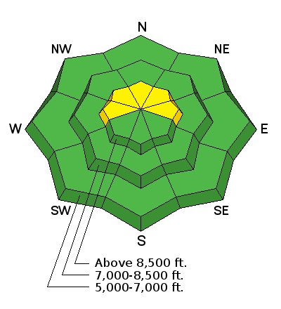
bottom line LOW (Level 1): Large and dangerous avalanches are unlikely in the backcountry today, and the snow appears stable on most slopes. Triggered stiff wind slabs and loose snow avalanches are possible however, mainly in steep upper elevation terrain. Use normal caution, continue to avoid steep drifted slopes at upper elevations, and practice companion rescue techniques with your backcountry partners.
|
 |
current conditions It's 24 degrees at the 8400' Tony Grove Snotel, and there's 47 inches of total snow, containing 87% of average water content for the date. The 9700' CSI Logan Peak weather station reports 23 degrees and an overnight southerly shift in the wind, averaging in the mid twenties and gusting to 35 mph from the southwest this morning. We've been able to find nice smooth recrystallized powder riding conditions even on sunny slopes in many areas, with low elevation snow adding more access options. Other than very weak snow on or near the surface, the snow on most slopes appears stable. After a couple weeks without significant accumulations and no new avalanches reported, the danger is low in most areas. Although wind slab and loose snow avalanches are certainly possible, (and most likely at upper elevations), currently large dangerous avalanches failing on deeper layers in the snowpack are unlikely in the backcountry. With fair weather and sunshine in the mountains, now is a great time to practice companion rescue with your backcountry partners.. It's quick, easy, and fun, and anyone can do it.
|
 |
recent activity
***To view our updated list of backcountry observations and avalanche activity from around Utah, go to our observations page
|
| type | aspect/elevation | characteristics |
|---|

|
|
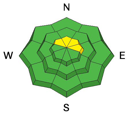
LIKELIHOOD
 LIKELY
UNLIKELY
SIZE
 LARGE
SMALL
TREND
 INCREASING DANGER
SAME
DECREASING DANGER
|
|
description
Avoid stiff and perhaps hollow sounding wind slabs near ridge tops and in and around terrain features like gullies, sub-ridges, scoops, and rock outcroppings. Wind slabs may have formed on weak faceted or feathery snow that was previously on the snow surface, which means the slabs could be reactive to our weight, and the older drifts may stay sensitive to human triggering for a little while.
|
| type | aspect/elevation | characteristics |
|---|

|
|
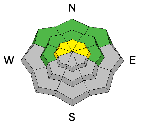
LIKELIHOOD
 LIKELY
UNLIKELY
SIZE
 LARGE
SMALL
TREND
INCREASING DANGER
SAME
DECREASING DANGER
|
|
description
Loose very weak snow can be found on the surface in many areas, and this is prone to avalanching on steep slopes. Triggered loose sluffs could entrain significant snow, especially on sustained slopes, so be sure no one is below and watch out for terrain traps like benches and gullies where the snow could pile up deeply.
|
 |
weather It'll be mostly sunny today, with a high temperature at 8500' around 34 degrees and southwest winds in the 10 to 15 mph range on the ridges. The first storm system will enter the zone tonight and bring with it the possibility of a few inches of accumulation and increasing west winds lasting into Thursday, (2 to 6 inches possible by tomorrow night). A stronger system will impact the zone Thursday night into Friday, with 5 to 9 inches of accumulation forecast. The weather looks like it will continue to be productive and remain unsettled well into next week. |
| general announcements The CROWBAR backcountry ski race will be Saturday January 30. More info at http://CrowbarSkiRace.org. Please submit snow and avalanche observations from your ventures in the backcountry HERE. You can call us at 801-524-5304 or email HERE, or include #utavy in your Instagram or Tweet us @UAClogan. To report avalanche activity in the Logan Area or to contact the local avalanche forecaster call me, Toby, at 435-757-7578. I'll update this advisory throughout the season on Monday, Wednesday, Friday, and Saturday mornings by about 7:30 This advisory is produced by the U.S.D.A. Forest Service, which is solely responsible for its content. It describes only general avalanche conditions and local variations always exist. |


