| Please join us at the 23rd annual Black Diamond Fall Fundraiser Party Thursday Sept 15. Tickets are on sale now here, at the Black Diamond store & at REI. Special bonus raffle for online ticket purchasers! |
| Please join us at the 23rd annual Black Diamond Fall Fundraiser Party Thursday Sept 15. Tickets are on sale now here, at the Black Diamond store & at REI. Special bonus raffle for online ticket purchasers! |
| Advisory: Logan Area Mountains | Issued by Toby Weed for Monday - January 11, 2016 - 6:53am |
|---|

|
bottom line MODERATE(Level 2): Drifting snow from increased northwest winds overnight created heightened wind slab avalanche conditions at upper elevations in the backcountry. Although rather unlikely, triggered deep slab avalanches failing on persistent weak layers remain possible in some areas. Evaluate the snow and terrain carefully, avoid steep drifted slopes at upper elevations, and practice companion rescue techniques with your backcountry partners.
|
 |
current conditions Sheltered and lower angled terrain still offer the best backcountry riding options. Sunny slopes are a bit crusty, but off of the wind damaged ridge-lines you can still find pretty good settled powder. Time, compression, and settlement are gradually healing the deep weaknesses in the snowpack, and dangerous deep slab avalanches continue to slowly become less likely. With a few inches of fresh snow on the surface, the overnight increase in wind caused drifting and an increase in danger of wind slab avalanches. You could trigger a avalanche today on a steep slope with recent deposits of drifted snow. It's 7 degrees at the 8400' Tony Grove Snotel, and it looks like we picked up an inch or two yesterday evening. There's 48 inches of total snow, containing 90% of average water content for the date. The 9700' CSI Logan Peak weather station reports 11 degrees and an overnight increase in northwest wind, currently averaging in the mid twenties and gusting to 35 mph this morning. With fair weather and sunshine in the mountains, now is a great time to practice companion rescue with your backcountry partners.. It's quick, easy, and fun, and anyone can do it.
|
 |
recent activity
***To view our updated list of backcountry observations and avalanche activity from around Utah, go to our observations page
|
| type | aspect/elevation | characteristics |
|---|

|
|
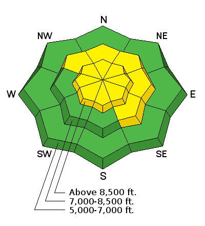
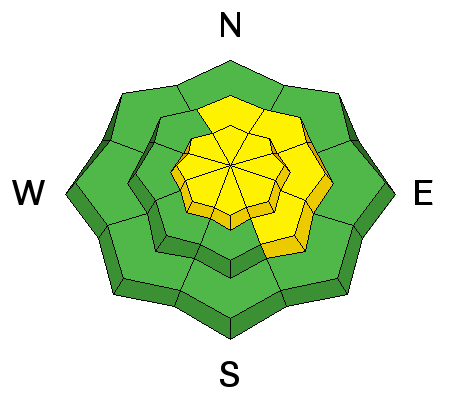
LIKELIHOOD
 LIKELY
UNLIKELY
SIZE
 LARGE
SMALL
TREND
 INCREASING DANGER
SAME
DECREASING DANGER
|
|
description
Expect recently formed and developing wind slabs near ridge tops and in and around terrain features like gullies, sub-ridges, scoops, and rock outcroppings. Wind slabs may have formed on weak faceted or feathery snow that was previously on the snow surface, which means the slabs could be reactive to our weight, and older drifts may stay sensitive to human triggering for a little while.
|
| type | aspect/elevation | characteristics |
|---|

|
|
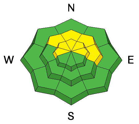
LIKELIHOOD
 LIKELY
UNLIKELY
SIZE
 LARGE
SMALL
TREND
 INCREASING DANGER
SAME
DECREASING DANGER
|
|
description
Time, settlement, and sintering are helping to gradually stabilize the snow, and in many areas the slab layer is so thick that it would be very difficult for riders to trigger. But, dangerous avalanches remain possible in some areas, and heightened avalanche conditions persist. Dangerous deep slab avalanches might be triggered from shallower areas on the slab, especially in outlying drifted terrain at upper and mid-elevations. ***Pay close attention to signs of unstable snow like recent avalanches, whumpfing, and shooting cracks, and be willing to reevaluate your plans. In these conditions you might still trigger avalanches remotely, from a distance or worse, from below!
|
 |
weather It'll be mostly sunny in the mountains, with a high temperature at 8500' of around 24 degrees and west-northwest wind of around 15 mph along the ridges. It'll be mostly clear tonight, with temperatures around 10 degrees and continuing moderate west winds. A high pressure system will persist though mid-week. A series of initially weak storm systems will cross over the region later in the week and into the weekend. The first system will bring with it the possibility of a few inches of accumulation Wednesday night and Thursday. |
| general announcements The CROWBAR backcountry ski race will be Saturday January 30. More info at http://CrowbarSkiRace.org. Please submit snow and avalanche observations from your ventures in the backcountry HERE. You can call us at 801-524-5304 or email HERE, or include #utavy in your Instagram or Tweet us @UAClogan. To report avalanche activity in the Logan Area or to contact the local avalanche forecaster call me, Toby, at 435-757-7578. I'll update this advisory throughout the season on Monday, Wednesday, Friday, and Saturday mornings by about 7:30 This advisory is produced by the U.S.D.A. Forest Service, which is solely responsible for its content. It describes only general avalanche conditions and local variations always exist. |


