| Please join us at the 23rd annual Black Diamond Fall Fundraiser Party Thursday Sept 15. Tickets are on sale now here, at the Black Diamond store & at REI. Special bonus raffle for online ticket purchasers! |  |

| Please join us at the 23rd annual Black Diamond Fall Fundraiser Party Thursday Sept 15. Tickets are on sale now here, at the Black Diamond store & at REI. Special bonus raffle for online ticket purchasers! |  |
| Advisory: Logan Area Mountains | Issued by Toby Weed for Friday - January 8, 2016 - 7:17am |
|---|
 |
current conditions Another inch of new snow fell yesterday evening, and it's 21 degrees at the Tony Grove Snotel at 8400'. There's 48 inches of total snow, containing 96% of average water content for the date. It's 14 degrees at the 9700' CSI Logan Peak weather station, with fairly light northeast wind. We've found the best riding in sheltered lower angled terrain. Sunny slopes have seen a few minor melts and refreezes, and many slopes sport a couple inches of heavier dust-on-crust. Off the wind damaged ridge-lines you can still find pretty good settled powder riding conditions in many areas. With a few inches of fresh snow on the surface, any increase in wind will cause an increase in danger of wind slab avalanches. Small, and some larger wind slab avalanches have been common in the area in the first week of 2016, and you could easily trigger an avalanche this weekend on a steep slope with recent deposits of drifted snow. Time, compression, and settlement are gradually healing the instabilities in the snowpack, and dangerous deep slab avalanches continue to slowly become less likely in the backcountry. Even so, both our snowpit tests and triggered activity on New Years Eve indicate that you might still trigger large and scary avalanches in some areas.
|
 |
recent activity
***To view our updated list of backcountry observations and avalanche activity from around Utah, go to our observations page
|
| type | aspect/elevation | characteristics |
|---|


|


|

LIKELIHOOD
 LIKELY
UNLIKELY
SIZE
 LARGE
SMALL
TREND
 INCREASING DANGER
SAME
DECREASING DANGER
|
|
description
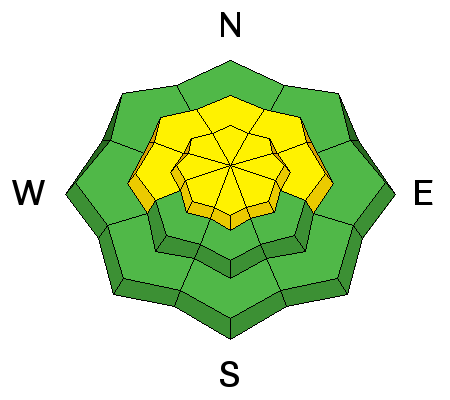
With a few inches of fresh snow in upper elevation fetch areas, if the winds increase, so will the avalanche danger. Expect freshly formed and developing wind slabs near ridge tops and in and around terrain features like gullies, sub-ridges, scoops, and rock outcroppings. Wind slabs may have formed and are still forming on weak faceted or feathery snow that was previously on the snow surface.
|
| type | aspect/elevation | characteristics |
|---|


|


|

LIKELIHOOD
 LIKELY
UNLIKELY
SIZE
 LARGE
SMALL
TREND
 INCREASING DANGER
SAME
DECREASING DANGER
|
|
description
Time, settlement, and sintering are helping to gradually stabilize the snow, and in many areas the slab layer is so thick that it would be very difficult for riders to trigger. But as recently proven near the Idaho state line, dangerous avalanches remain possible in some areas, and heightened avalanche conditions persist. Dangerous deep slab avalanches might be triggered from shallower areas on the slab, especially in outlying drifted terrain at upper and mid-elevations. In addition to deeply buried facets and depth hoar, we also clearly need to keep an eye on the weakness associated with the widespread December 8/9 crust layer. ***Pay close attention to signs of unstable snow like recent avalanches, whumpfing, and shooting cracks, and be willing to reevaluate your plans. In these conditions you could still trigger avalanches remotely, from a distance or worse, from below!
|
 |
weather STATE WEATHER SYNOPSIS...AN UPPER LOW WILL MOVE OFF TO THE EAST TODAY. A MOIST NORTHWEST FLOW IN THE WAKE OF THIS LOW WILL CONTINUE OVER THE AREA INTO FRIDAY NIGHT. ANOTHER MUCH WEAKER SYSTEM WILL GRAZE SOUTHWESTERN UTAH SATURDAY NIGHT AND SUNDAY. |
| general announcements The CROWBAR backcountry ski race will be Saturday January 30. More info at http://CrowbarSkiRace.org. Please submit snow and avalanche observations from your ventures in the backcountry HERE. You can call us at 801-524-5304 or email HERE, or include #utavy in your Instagram or Tweet us @UAClogan. To report avalanche activity in the Logan Area or to contact the local avalanche forecaster call me, Toby, at 435-757-7578. I'll update this advisory throughout the season on Monday, Wednesday, Friday, and Saturday mornings by about 7:30 This advisory is produced by the U.S.D.A. Forest Service, which is solely responsible for its content. It describes only general avalanche conditions and local variations always exist. |
Advisory Hotline: (888) 999-4019 | Contact Information