| Please join us at the 23rd annual Black Diamond Fall Fundraiser Party Thursday Sept 15. Tickets are on sale now here, at the Black Diamond store & at REI. Special bonus raffle for online ticket purchasers! |
| Please join us at the 23rd annual Black Diamond Fall Fundraiser Party Thursday Sept 15. Tickets are on sale now here, at the Black Diamond store & at REI. Special bonus raffle for online ticket purchasers! |
| Advisory: Logan Area Mountains | Issued by Toby Weed for Sunday - January 3, 2016 - 7:25am |
|---|

|
bottom line MODERATE (Level 2): Southeast winds built drifts on preexisting weak snow, and heightened wind slab avalanche conditions exist on drifted slopes at upper elevations in the backcountry. Although becoming rather unlikely, dangerous deep slab avalanches remain possible in some areas and might be triggered from a shallow or rocky area. Deep slab avalanches might be triggered remotely, from a distance or possibly from below. Evaluate the snow and terrain carefully and avoid steep drifted slopes at upper elevations.
|
 |
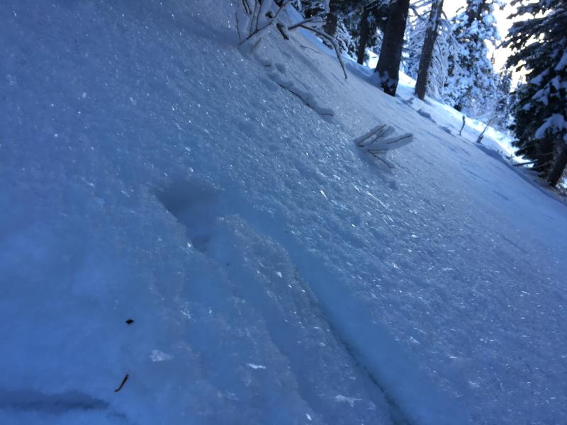
current conditions East and southeast winds Friday found plenty of nice soft powder to drift at upper elevations. We've noticed the rapid development of small grained near surface facets and frost crystals or surface hoar on the snow surface in the past few days. Once buried, these can become thin persistent weak layers. Drifting yesterday created sensitive wind slabs on top of weak surface snow, and a few parties in different areas in the zone observed natural avalanches...
We're keeping an eye on the snow surface these days, since weak layers commonly develop on or near the snow surface during high pressure conditions. We watched as V Feathery surface hoar or frost crystals grew on the snow surface during the day yesterday. (12-31-2015) The Tony Grove Snotel at 8400' reports 27 degrees this morning and 48 inches of total snow, containing 98% of average water content for the date. It's 26 degrees at the 9700' CSI Logan Peak weather station, which is showing continuing sustained southeasterly winds averaging in the mid twenties this morning.
|
 |
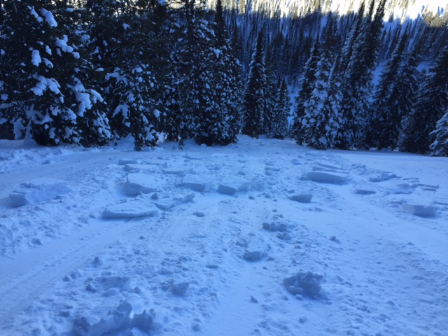
recent activity Yesterday riders triggered several manageable wind slabs in the Tony Grove Area. These were around 30 feet wide and around 8" deep Parties on New Years Day reported significant drifting and observed fresh natural wind slab avalanches in Wood Camp and Logan Dry Canyon, and and a skier reports triggering a fresh wind slab near Millville Peak in Providence Canyon.
A fresh triggered wind slab avalanche in Providence Canyon and a natural in Wood Camp. (observers 1-1-2016) ***DB Bowl Avalanche: Here's a new video looking at a recent natural avalanche in Logan Dry Canyon. Evidence of significant natural activity from the productive pre-Christmas storm is widespread across the Logan Zone. Most of the natural avalanches occurred early in the storm, but there are also a few that appear to be a bit more recent.
***To view our updated list of backcountry observations and avalanche activity from around Utah, go to our observations page
|
| type | aspect/elevation | characteristics |
|---|

|
|
LIKELIHOOD
 LIKELY
UNLIKELY
SIZE
 LARGE
SMALL
TREND
 INCREASING DANGER
SAME
DECREASING DANGER
|
|
description
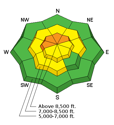
East and southeast winds yesterday and overnight drifted light surface snow in exposed terrain, and fresh wind slabs developed near ridge tops and in and around terrain features like gullies and rock outcroppings. The wind slabs formed on weak sugary or faceted snow that was on the snow surface at the end of last year. Several natural avalanches and an unintentionally triggered slide were reported in the Logan Zone yesterday, and you are still likely to trigger wind slabs in drifted terrain today. Yesterday's fresh slabs were fairly small and generally of the manageable type, but today's might be a bit larger and harder so you should avoid steep drifted terrain. The weight of a smaller wind slab avalanche overrunning a slope below might trigger a larger and more destructive avalanche involving old weak snow.
|
| type | aspect/elevation | characteristics |
|---|

|
|
LIKELIHOOD
 LIKELY
UNLIKELY
SIZE
 LARGE
SMALL
TREND
INCREASING DANGER
SAME
DECREASING DANGER
|
|
description
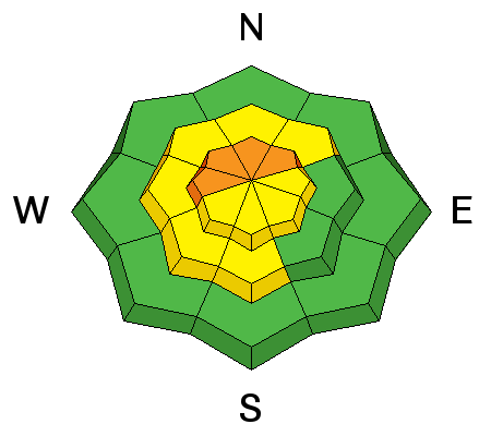
Widespread very weak snow was overloaded by a few feet of heavier drifted snow last week creating an unstable situation, with a cohesive slab sitting on weak sugary or faceted snow. Settlement and cold temperatures have helped to stabilize the snow and in many areas the slab layer is so thick that it would be very difficult for riders to trigger, but heightened avalanche conditions persist in many areas and dangerous deep slab avalanches might be triggered from shallower areas on the slab today, especially in outlying drifted terrain at upper and mid-elevations. ***Pay close attention to signs of unstable snow like recent avalanches, whumpfing, and shooting cracks, and be willing to reevaluate your plans. In these conditions you could still trigger avalanches remotely, from a distance or worse, from below!
|
 |
weather STATE WEATHER SYNOPSIS...VALLEY INVERSIONS WILL REMAIN IN PLACE THROUGH THE FIRST PART OF THE WEEK. A SERIES OF WEAK BUT SOMEWHAT MOIST WEATHER SYSTEMS WILL CROSS THE REGION BEGINNING MONDAY AND CONTINUING THROUGHOUT THE WEEK. |
| general announcements The CROWBAR backcountry ski race will be Saturday January 30. More info at http://CrowbarSkiRace.org. Please submit snow and avalanche observations from your ventures in the backcountry HERE. You can call us at 801-524-5304 or email HERE, or include #utavy in your Instagram or Tweet us @UAClogan. To report avalanche activity in the Logan Area or to contact the local avalanche forecaster call me, Toby, at 435-757-7578. I'll update this advisory throughout the season on Monday, Wednesday, Friday, and Saturday mornings by about 7:30 This advisory is produced by the U.S.D.A. Forest Service, which is solely responsible for its content. It describes only general avalanche conditions and local variations always exist. |