| Please join us at the 23rd annual Black Diamond Fall Fundraiser Party Thursday Sept 15. Tickets are on sale now here, at the Black Diamond store & at REI. Special bonus raffle for online ticket purchasers! |
| Please join us at the 23rd annual Black Diamond Fall Fundraiser Party Thursday Sept 15. Tickets are on sale now here, at the Black Diamond store & at REI. Special bonus raffle for online ticket purchasers! |
| Advisory: Logan Area Mountains | Issued by Toby Weed for Monday - December 28, 2015 - 7:17am |
|---|

|
bottom line MODERATE (level 2): Heightened avalanche conditions still exist in the backcountry, especially in drifted terrain at upper and mid elevations. Dangerous triggered deep slab avalanches are possible in some areas. You might trigger avalanches remotely, from a distance or possibly from below. Evaluate the snow and terrain carefully, make conservative decisions, and continue to avoid travel on or below steep drifted slopes that have not recently avalanched.
|
 |
current conditions The snow is becoming more stable in the backcountry, but you could still trigger dangerous avalanches in some areas. The good news is, cold temperatures are keeping the powder nice and soft on most slopes, even in the sun. You'll find nice powder riding conditions across the zone, and with instant good coverage, thanks to Santa, there are many available options, so you don't have to risk travel in steep drifted terrain to find untracked snow. Last week's snow settled into a stiff enough layer to mostly support a sled in the alpine meadows. The cold snow is a bit slow, but it's fairly easy to break trail. The Tony Grove Snotel at 8400' reports 58 inches of total snow, containing 104% of average water content for the date. It's 11 degrees at the 9700' CSI Logan Peak weather station, which is showing southwest winds averaging in the twenties this morning.
|
 |
recent activity Evidence of natural activity from last week's productive storm is widespread across the Logan Zone. Most of the natural avalanches occurred early in the storm, but there are also a few that appear to be more recent. Large avalanches were triggered in the Wasatch and Uinta Ranges on the day after Christmas, but no incidents were reported locally since the weekend before Christmas.
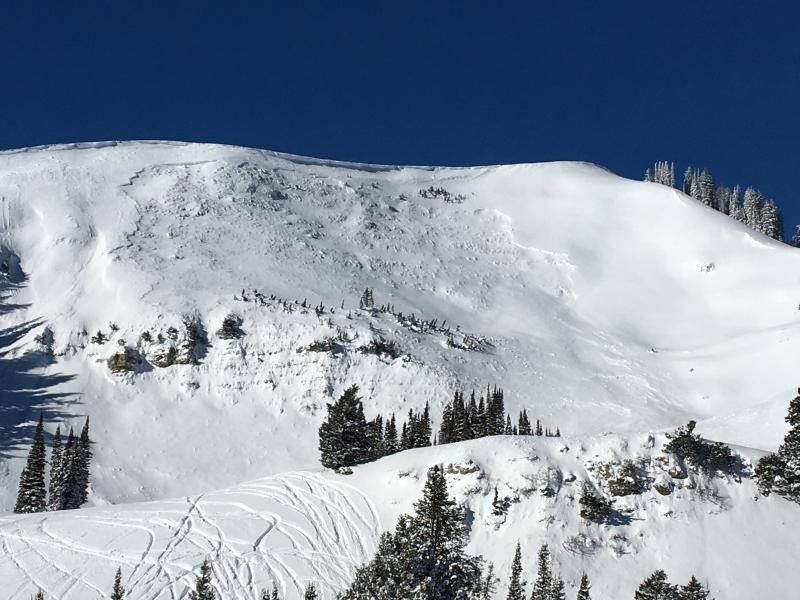
There was extensive natural avalanche activity in upper Providence Canyon, with large avalanches having occurred at different times during the pre-Christmas Storm. Most of the large paths in the area avalanched. Pictures above are of Three Terraces Bowl and the crown of a slide on the north side of Providence Peak. Both look to have gone big around Christmas Eve. I think the activity was natural, but being in such a popular riding area, some of the avalanches may have been remote triggered.(12-26-15) ***To view our updated list of backcountry observations and avalanche activity from around Utah, go to our observations page
|
| type | aspect/elevation | characteristics |
|---|

|
|
LIKELIHOOD
 LIKELY
UNLIKELY
SIZE
 LARGE
SMALL
TREND
 INCREASING DANGER
SAME
DECREASING DANGER
|
|
description
Widespread very weak snow was overloaded by a few feet of heavier drifted snow last week creating an unstable situation, with a cohesive slab sitting on weak sugary or faceted snow. Settlement and cold temperatures have helped to stabilize the snow, but heightened avalanche conditions persist in many areas and dangerous triggered deep slab avalanches remain possible today, especially in drifted terrain at upper and mid-elevations. ***Pay close attention to signs of unstable snow like recent avalanches, whumpfing, and shooting cracks, and be willing to reevaluate your plans. In these conditions you could still trigger avalanches remotely, from a distance or worse, from below!
|
| type | aspect/elevation | characteristics |
|---|

|

|
LIKELIHOOD
LIKELY
UNLIKELY
SIZE
 LARGE
SMALL
TREND
 INCREASING DANGER
SAME
DECREASING DANGER
|
|
description
Sustained southwest winds overnight drifted snow in exposed terrain and shallow fresh wind slabs developed near ridge tops and in and around terrain features like gullies and rock outcroppings. A manageable wind slab avalanche overrunning a slope below might trigger a larger and more destructive avalanche involving old weak snow.
|
 |
weather High pressure conditions will strengthen today, with 8500' high temperatures around 17 degrees and fairly light southwest winds. It'll be mostly cloudy tonight with low temperatures around 5 degrees and a 50 % chance of snow showers, but little in the way of accumulation expected. A series of weak troughs will cross over the zone Monday through Wednesday, bringing the possibility of a few inches of light snow. High pressure conditions will redevelop later in the week and for New Years Day.
|
| general announcements Please submit snow and avalanche observations from your ventures in the backcountry HERE. You can call us at 801-524-5304 or email HERE, or include #utavy in your Instagram or Tweet us @UAClogan. To report avalanche activity in the Logan Area or to contact the local avalanche forecaster call me, Toby, at 435-757-7578. I'll update this advisory throughout the season on Monday, Wednesday, Friday, and Saturday mornings by about 7:30 This advisory is produced by the U.S.D.A. Forest Service, which is solely responsible for its content. It describes only general avalanche conditions and local variations always exist. |