| Please join us at the 23rd annual Black Diamond Fall Fundraiser Party Thursday Sept 15. Tickets are on sale now here, at the Black Diamond store & at REI. Special bonus raffle for online ticket purchasers! |
| Please join us at the 23rd annual Black Diamond Fall Fundraiser Party Thursday Sept 15. Tickets are on sale now here, at the Black Diamond store & at REI. Special bonus raffle for online ticket purchasers! |
| Advisory: Logan Area Mountains | Issued by Toby Weed for Saturday - December 26, 2015 - 7:17am |
|---|

|
bottom line CONSIDERABLE (level 3): Dangerous avalanche conditions exist, especially in drifted terrain at upper and mid elevations. Large and destructive triggered avalanches remain likely in some areas. Resist the temptation, and continue to avoid travel on or below drifted upper elevation slopes steeper than about 30 degrees. Careful snowpack evaluation, cautious routefinding and conservative decision-making will be essential in the backcountry this weekend.
|
 |
special avalanche bulletin THIS SPECIAL AVALANCHE ADVISORY IS FOR THE MOUNTAINS OF NORTHERN UTAH, TO INCLUDE SOUTHEAST IDAHO, THE BEAR RIVER RANGE, THE WASATCH RANGE, AND THE WESTERN UINTAS. HEAVY SNOW AND STRONG WINDS HAVE LED TO DANGEROUS AVALANCHE CONDITIONS WITH MANY AVALANCHES BREAKING TO THE GROUND. AVOID BEING ON OR BENEATH STEEP TERRAIN AS THESE AVALANCHES MAY BE TRIGGERED FROM BELOW. THIS ADVISORY DOES NOT INCLUDE SKI AREAS OR HIGHWAYS WHERE AVALANCHE CONTROL IS NORMALLY DONE. FOR MORE INFORMATION VISIT WWW.UTAHAVALANCHECENTER.ORG OR CALL 1-888-999-4019. |
 |
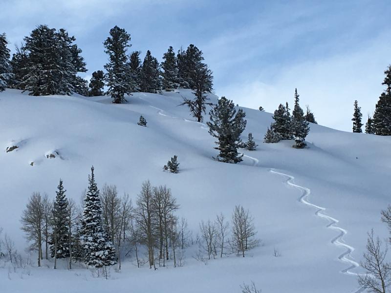
current conditions You'll be able to find nice deep powder riding conditions in the backcountry this weekend, and if you stick to lower angled, lower elevation, and sheltered terrain you'll be able to have fun and be safe. Heavy snowfall and sustained winds overloaded a widespread weak preexisting base, creating dangerous avalanche conditions in many areas. History tells us we're set up for avalanche accidents on a sunny weekend day after a major storm and natural avalanche cycle as the snow only gradually becomes more stable. On days like these people are likely to be lured by the powder sirens into steep drifted terrain. Resist the urge this weekend, and stick to slopes less than 30 degrees, play in the deep powder meadows well out from under the steeper hills, or explore those secret lower elevation powder stashes.
You'll be able to find great powder riding conditions in the backcountry this weekend. If you stick to lower angled terrain and stay off and out from under steep slopes, you'll be able to have fun in the deep powder and stay safe. (12-24-15) After a very productive pre-Christmas storm, the Tony Grove Snotel at 8400' reports a gain of 5.3" of water and a few feet of snow since last weekend. The station is showing significant settlement of the fresh powder despite cold temperatures. It's 6 degrees this morning and there's now 62 inches of total snow, now containing 108% of average water content for the date. It's negative 1 degree at the 9700' CSI Logan Peak weather station, which is showing increasing winds from the northwest this morning, currently averaging around 15 mph.
|
 |
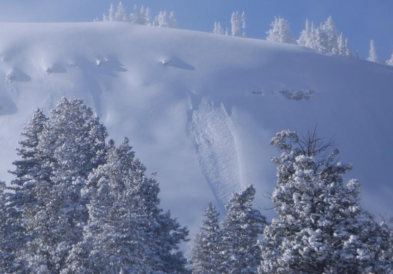
recent activity Evidence of natural activity from the prolonged pre-Christmas storm is visible from Cache Valley, and looks to have been fairly widespread across the zone... Looks like a number of good sized avalanches occurred early in the storm, Monday Night or Tuesday. The crowns and debris piles are largely blown-in by substantial drifting and obscured by around 2 feet of powder received since. Of note; I could see evidence of significant activity in the usual suspect east facing paths in the Wellsville Range including Pine Canyon, on the east face of Mt. Magog, an in the Music Note Area in Mill Hollow. Of greater concern are the many suspect steep slopes and avalanche paths in the area that do not show any signs of recent natural activity. Many of these may sitting in a balanced state, just lying in wait for a person to trigger.
A fresh soft slab avalanche in drifted upper elevation terrain near Grandfather Cornice on Cornice Ridge. (12-24-15)
Many large and dangerous natural and triggered avalanches have occurred around the state in the last few days, and it looks like it'll be a dangerous weekend as folks start venturing further out into the backcountry. ***To view our updated list of backcountry observations and avalanche activity from around Utah, go to our observations page
|
| type | aspect/elevation | characteristics |
|---|

|
|
LIKELIHOOD
 LIKELY
UNLIKELY
SIZE
 LARGE
SMALL
TREND
 INCREASING DANGER
SAME
DECREASING DANGER
|
|
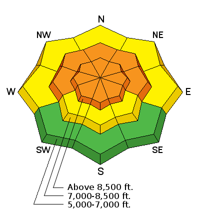
description
Widespread very weak snow is now overloaded by a few feet of heavier drifted snow and deceptive powder, and dangerous avalanche conditions exist in many areas. Certainly some stabilization has occurred with the mellower weather in the past couple days, but dangerous deep slab avalanches remain likely today, especially in drifted terrain at upper and mid-elevations. ***You should give avalanche paths and slopes steeper than about 30 degrees more time to strengthen after the huge load they received earlier on the week It'll be wise to continue to avoid drifted slopes steeper than about 30 degrees, but if you venture into the backcountry, pay close attention to signs of unstable snow like recent avalanches, whumpfing, and shooting cracks, and be willing to reevaluate your plans. In these conditions you could trigger avalanches remotely, from a distance or worse, from below!
|
| type | aspect/elevation | characteristics |
|---|

|
|
LIKELIHOOD
LIKELY
UNLIKELY
SIZE
 LARGE
SMALL
TREND
INCREASING DANGER
SAME
DECREASING DANGER
|
|
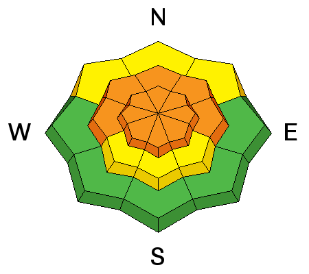
description
Northwest winds are intensifying this morning, and on Christmas Eve, South winds drifted significant quantities of light surface snow into lee slope deposition areas creating sensitive wind slabs 1 to 2 feet deep. These could fail on a storm interface or a density change within the recent snow. A smaller wind slab avalanche overrunning a slope below could trigger a larger and more destructive avalanche involving old weak snow.
|
 |
weather Cold temperatures will continue, but clearing and sunshine is expected for the weekend. It'll be mostly sunny and quite cold today, with gradually diminishing northeast winds and 8500' high temperatures around 10 degrees. Gusts of around 35 mph from the Northeast are expected this morning and the wind will push wind chills close to negative 20 degrees! It'll be clear and cold tonight in the mountains, with a low temperature of -5 expected. It'll be sunny again tomorrow, with temperatures climbing into the twenties. A series of weak troughs will cross over the zone Monday through Wednesday, and high pressure conditions will redevelop later in the week.
|
| general announcements Please submit snow and avalanche observations from your ventures in the backcountry HERE. You can call us at 801-524-5304 or email HERE, or include #utavy in your Instagram or Tweet us @UAClogan. To report avalanche activity in the Logan Area or to contact the local avalanche forecaster call me, Toby, at 435-757-7578. I'll update this advisory throughout the season on Monday, Wednesday, Friday, and Saturday mornings by about 7:30 This advisory is produced by the U.S.D.A. Forest Service, which is solely responsible for its content. It describes only general avalanche conditions and local variations always exist. |