| Please join us at the 23rd annual Black Diamond Fall Fundraiser Party Thursday Sept 15. Tickets are on sale now here, at the Black Diamond store & at REI. Special bonus raffle for online ticket purchasers! |
| Please join us at the 23rd annual Black Diamond Fall Fundraiser Party Thursday Sept 15. Tickets are on sale now here, at the Black Diamond store & at REI. Special bonus raffle for online ticket purchasers! |
| Advisory: Logan Area Mountains | Issued by Toby Weed for Wednesday - December 23, 2015 - 7:21am |
|---|

|
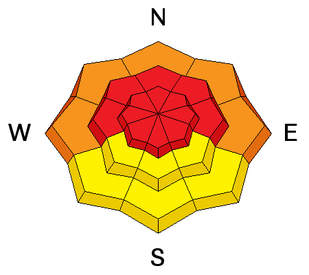
bottom line HIGH (level 4): Resist the temptation and avoid travel in backcountry avalanche terrain today. Stay off of and out from under slopes steeper than 30 degrees and obvious or historic avalanche paths. Very dangerous avalanche conditions exist, especially in drifted terrain at upper and mid elevations. Large and destructive natural and human triggered avalanches are likely, and the continuing storm will only cause the danger to rise and become more widespread.
|
 |
avalanche warning THE FOREST SERVICE UTAH AVALANCHE CENTER IN SALT LAKE CITY HAS EXTENDED THE BACKCOUNTRY AVALANCHE WARNING. * TIMING...THROUGH 6 AM MST THURSDAY * AFFECTED AREA...ALL THE MOUNTAINS OF NORTHERN AND CENTRAL UTAH AND SOUTHEASTERN IDAHO TO INCLUDE THE WASATCH RANGE, THE BEAR RIVER RANGE, THE WESTERN UINTAS AND THE MANTI-SKYLINE PLATEAU. OTHER MOUNTAIN RANGES WILL LIKELY BE AFFECTED AS WELL * AVALANCHE DANGER...THE AVALANCHE DANGER FOR THE WARNING AREA IS HIGH * IMPACTS...HEAVY SNOWFALL COMBINED WITH STRONG WIND CREATING WIDESPREAD AREAS OF UNSTABLE SNOW. BOTH HUMAN TRIGGERED AND NATURAL AVALANCHES ARE LIKELY AND WILL OCCUR IN MANY AREAS. STAY OFF OF AND OUT FROM UNDER SLOPES STEEPER THAN 30 DEGREES. |
 |
current conditions There is a HIGH danger and you should continue to avoid backcountry travel in avalanche terrain today. Heavy snowfall and extensive drifting from strong and sustained southwest winds overloaded a very weak preexisting base, and unstable, avalanche-prone snow exists over widespread areas. Very weak faceted snow is widespread in the basal layers of the snowpack at mid and upper elevations. Rapidly accumulating and drifting heavy snow is in the process of creating a heavier slab layer on top of the weak base, and worsening avalanche conditions have already become very dangerous in the backcountry around Logan. The Tony Grove Snotel at 8400' reports around 24 inches of new snow in the last 48 hours, containing 3.2" of water. It's 19 degrees again this morning and there's 60 inches of total snow now containing exactly 100% of average water content for the date. It's 11 degrees at the 9700' CSI Logan Peak weather station, which recorded fairly light west wind overnight, but it's starting to intensify a bit out of the the southwest this morning. Overnight west northwest winds blew in the 20 mph range and gusted into the 30s at the UDOT hwy 89 Logan Summit weather station.
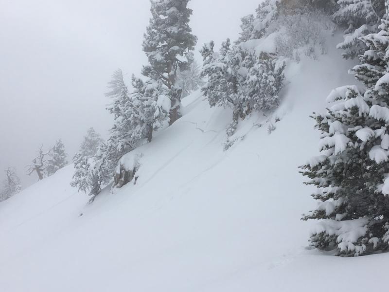
The snow in the backcountry on the mostly gentle backside of Beaver Mt. showed many obvious signs of instability yesterday including extensive audible collapsing or whumpfing and very long, sometimes remote triggered shooting cracks. (Pagnucco, 12-21-2015)
|
 |
recent activity Saturday (12-19-15): A very experienced local rider who was separated from his companion is lucky to be alive after triggering a good sized avalanche, being caught and carried through thick trees, and then being mostly buried and trapped in the debris. Sunday (12-20-15): A skier reported remote triggering a large hard slab avalanche yesterday afternoon on a drifted north facing slope high on the south rim of Logan Canyon off the ridge deviding Logan Canyon from Dry Canyon..... Go to his Report
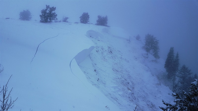
A sizable remote triggered avalanche from Sunday in the backcountry above Logan Canyon. (Syrstad, 12-20-15)
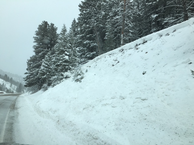
The snowplow triggered a couple persistent slab avalanches yesterday at lower elevations on the Hwy 89 road cut in Beaver Canyon. These were close to two feet deep and released on weak basal layer facets, sliding to the ground. (12-21-15) Poor visibility yesterday prevented us from seeing the probable natural activity in the backcountry, but extensive avalanche activity was reported from the Wasatch and Uinta Ranges, and we have a very similar weak snowpack and picked up as much or more snow locally. ***To view our updated list of backcountry observations and avalanche activity from around Utah, go to our observations page
|
| type | aspect/elevation | characteristics |
|---|

|
|
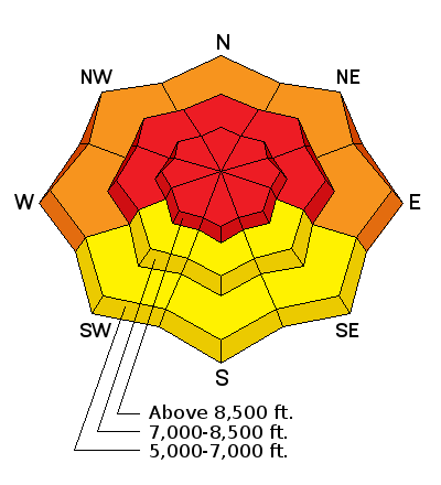
LIKELIHOOD
 LIKELY
UNLIKELY
SIZE
 LARGE
SMALL
TREND
 INCREASING DANGER
SAME
DECREASING DANGER
|
|
description
A slab layer consiting of settled snow from last week and drifted fresh snow from the current storm is overloading existing widespread very weak faceted snow, and we are entering a very dangerous and scary period in the backcountry. Dangerous persistent slab avalanches are likely in drifted terrain at upper and mid-elevations, and heavy snowfall and drifting today will cause the danger to increase and become more widespread. Natural activity is most likely during periods of particularly heavy snowfall and/or extensive drifting, and dangerous and destructive humman triggered avalanches are likely on steep slopes, many of which have just or are about to reach the tipping point. ***Pay close attention to signs of unstable snow like recent avalanches, whumpfing, and shooting cracks, and be willing to reevaluate your plans. In these conditions you might trigger avalanches remotely, from a distance or worse, from below!
|
| type | aspect/elevation | characteristics |
|---|

|
|
LIKELIHOOD
LIKELY
UNLIKELY
SIZE
LARGE
SMALL
TREND
 INCREASING DANGER
SAME
DECREASING DANGER
|
|
description
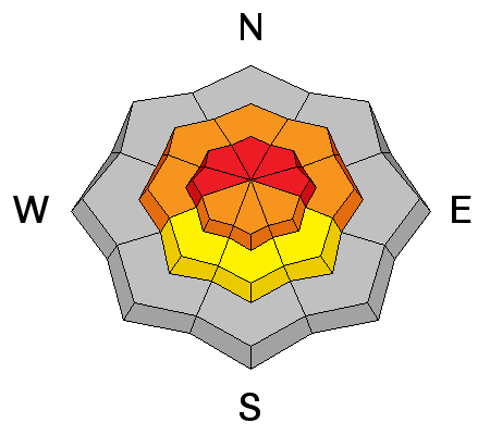
Deeper hard slab avalanches, also failing on weak faceted snow in the basal layers of the snowpack are possible in drifted upper elevation terrain. The continuing storm will only cause larger and more destructive avalanches and the danger to rise and become more widespread.
|
 |
weather We can expect periods heavy snowfall and sustained westerly winds again today, with 5 to 9 inches of accumulation this evening. The next wave of stormy weather is expected to bring a bit more snow and wind tomorrow evening and Christmas Day. |
| general announcements Please submit snow and avalanche observations from your ventures in the backcountry HERE. You can call us at 801-524-5304 or email HERE, or include #utavy in your Instagram or Tweet us @UAClogan. To report avalanche activity in the Logan Area or to contact the local avalanche forecaster call me, Toby, at 435-757-7578. I'll update this advisory throughout the season on Monday, Wednesday, Friday, and Saturday mornings by about 7:30 This advisory is produced by the U.S.D.A. Forest Service, which is solely responsible for its content. It describes only general avalanche conditions and local variations always exist. |