| Please join us at the 23rd annual Black Diamond Fall Fundraiser Party Thursday Sept 15. Tickets are on sale now here, at the Black Diamond store & at REI. Special bonus raffle for online ticket purchasers! |
| Please join us at the 23rd annual Black Diamond Fall Fundraiser Party Thursday Sept 15. Tickets are on sale now here, at the Black Diamond store & at REI. Special bonus raffle for online ticket purchasers! |
| Advisory: Logan Area Mountains | Issued by Toby Weed for Friday - December 18, 2015 - 6:39am |
|---|


|
bottom line CONSIDERABLE (level 3): Dangerous avalanche conditions exist on drifted slopes at upper elevations in the backcountry, and in some areas you are likely to trigger potentially large and destructive avalanches. Careful snowpack evaluation, cautious routefinding and conservative decision-making will be essential today. Avoid travel on or below drifted upper elevation slopes steeper than about 30 degrees.
|
 |
current conditions Many avalanche paths in the Logan Zone may be hanging in a delicate balance. Although significant natural activity has yet to occur, a stiffer slab layer is forming on top of widespread very weak faceted snow and in some upper elevation areas, steep drifted slopes are likely close to the tipping point. The Tony Grove Snotel at 8400' reports 13 inches of light snow from Wednesday Night, and another inch of new snow overnight. The 24 hour total now containing .9" of water. There's 36 inches of total snow at the site containing 67% of average water content for the date. Southwest winds increased last night, easily drifting the light snow, with the CSI Logan Peak weather station recording sustained average wind speeds in the upper twenties and gusts of around 40 mph. I'm reading 18 degrees at 9700' and 10 degrees at Beaver Mountain. Dangerous avalanche conditions exist today, especially in wind exposed upper elevation terrain, but nice, bottomless (or baseless) powder riding conditions can be found on lower angled slopes, down lower in elevation, and in sheltered areas. Very weak faceted snow is widespread at mid and upper elevations in the Bear River Range, and it's now capped by a rather inconsistent rime or rain-crust and up to around a foot-and-a-half of light powder. Wind and accumulating snow are in the process of creating a heavier slab layer on top of the loose faceted snow.
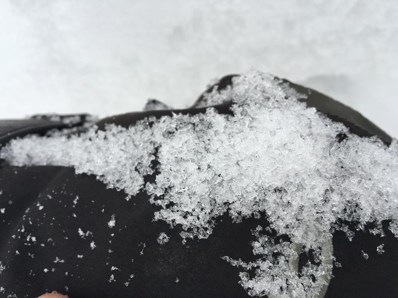
Loose faceted snow crystals plague the shallow snowpack in the Logan Zone. (12-15-2015)
|
 |
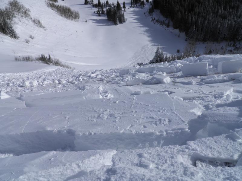
recent activity There was significant natural and remote triggered activity in the Wasatch Range Backcountry above Park City yesterday... Go to our observations page for more details..
One of several remote triggered avalanches from yesterday in the backcountry above Park City. (Staples, 12-17-15) No avalanche activity has been reported in the Logan backcountry recently.
|
| type | aspect/elevation | characteristics |
|---|

|

|
LIKELIHOOD
 LIKELY
UNLIKELY
SIZE
 LARGE
SMALL
TREND
 INCREASING DANGER
SAME
DECREASING DANGER
|
|
description
***Pay close attention to signs of unstable snow like whoompfing and shooting cracks, and be willing to reevaluate your plans. In these conditions you might trigger avalanches remotely, from a distance or worse, from below! Very weak faceted snow is widespread across the zone at mid and upper elevations. Last night's increase in southwest wind and significant accumulations of easily drifted light snow might be enough to overload the very weak basal snow on some slopes, and dangerous triggered persistent slab avalanches are likely, especially in drifted terrain at upper elevations. There is a Considerable danger at upper elevations and careful snowpack evaluation, cautious routefinding and conservative decision-making will be essential for safe backcountry travel.
|
| type | aspect/elevation | characteristics |
|---|

|
|
LIKELIHOOD
LIKELY
UNLIKELY
SIZE
 LARGE
SMALL
TREND
 INCREASING DANGER
SAME
DECREASING DANGER
|
|
description
Southwest winds picked up overnight and there was lots of nice light powder on the snow surface and falling, so drifting certainly occurred and will be ongoing today in upper elevation terrain. Wind slab avalanches are likely to become more sensitive to human triggering as the slabs continue to build, and they may step down into weak basal snow near the ground or pull out a persistent slab in descent. Avoid travel in steep drifted terrain today....
|
 |
weather Snow is possible in the mountains this morning as a weak warm front crosses the zone, but not much will accumulate. It'll gradually become partly sunny this afternoon and 8500' high temperatures of 33 degrees and southwest winds averaging 15 to 20 mph are expected. The next Pacific Storm will move in Saturday Night, bringing a decent shot of snow before moving off to the east on Sunday. Looks like an active very moist and windy weather pattern will set up for next week, keeping things interesting and contributing to significant avalanche concerns.... |
| general announcements Please submit snow and avalanche observations from your ventures in the backcountry HERE. You can call us at 801-524-5304 or email HERE, or include #utavy in your Instagram or Tweet us @UAClogan. To report avalanche activity in the Logan Area or to contact the local avalanche forecaster call me, Toby, at 435-757-7578. I'll update this advisory throughout the season on Monday, Wednesday, Friday, and Saturday mornings by about 7:30 This advisory is produced by the U.S.D.A. Forest Service, which is solely responsible for its content. It describes only general avalanche conditions and local variations always exist. |