| Please join us at the 23rd annual Black Diamond Fall Fundraiser Party Thursday Sept 15. Tickets are on sale now here, at the Black Diamond store & at REI. Special bonus raffle for online ticket purchasers! |
| Please join us at the 23rd annual Black Diamond Fall Fundraiser Party Thursday Sept 15. Tickets are on sale now here, at the Black Diamond store & at REI. Special bonus raffle for online ticket purchasers! |
| Advisory: Logan Area Mountains | Issued by Toby Weed for Wednesday - December 16, 2015 - 7:13am |
|---|

|
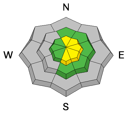
bottom line MODERATE (level 2): Heightened avalanche conditions exist in the backcountry and you could trigger dangerous persistent or wind slab avalanches on slopes steeper than about 30 degrees in drifted terrain, mainly at upper elevations. The danger will rise and become more widespread with accumulating snowfall and intensifying west winds later today and overnight, with dangerous (level 3) conditions likely to develop in some areas by tomorrow. Evaluate the snow and terrain carefully and continue to practice wise travel protocols.
|
 |
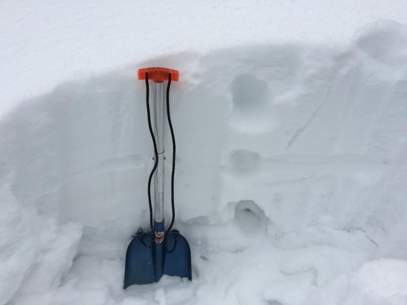
current conditions The Tony Grove Snotel at 8400' reports 2 inches of light snow overnight, containing .1" of water. There's 29 inches of total snow at the site containing 63% of average water content for the date. Northwest winds continue drifting some of the light snow around, with the UDOT Hwy 89 Summit weather station recording average wind speeds in the upper teens and gusts in the mid twenties. The CSI Logan Peak weather station is currently reporting single digit average NW wind speeds and a chilly 4 degrees at 9700' this morning. Very weak faceted snow is widespread at mid and upper elevations in the Bear River Range, and it's now capped by a rather inconsistent rime or rain-crust and up to around a foot of light powder. Wind and accumulating snow a creating a heavier slab layer on top of the loose faceted snow.
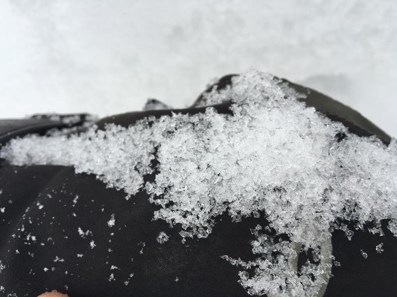
Loose faceted snow crystals plague the shallow snowpack in the Logan Zone. (12-15-2015) The shallow snow is quite weak across the Logan Zone and in the Providence Canyon where I found fist hard snow from top to bottom. (12-15-2015)
|
 |
recent activity Ski areas in the Ogden and Salt Lake Area mountains report some activity from control work yesterday, with a few triggered avalanches going pretty big, stepping down to the rocks, and involving old sugary snow in the basal layers of the snowpack. No avalanche activity has been reported in the Logan backcountry recently.
|
| type | aspect/elevation | characteristics |
|---|

|
|
LIKELIHOOD
 LIKELY
UNLIKELY
SIZE
 LARGE
SMALL
TREND
 INCREASING DANGER
SAME
DECREASING DANGER
|
|
description
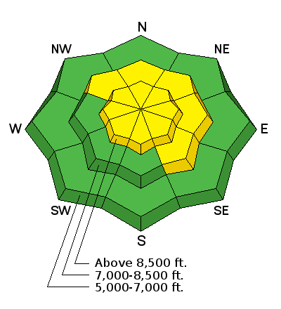
Accumulating snow and westerly winds will cause the avalanche danger to rise this afternoon and overnight, and dangerous persistent slab avalanche conditions are likely to develop in some areas by tomorrow. Very weak faceted snow is widespread across the zone at mid and upper elevations. Last week's moist snow and rime capped the sugary old snow with a plaster-like coating. This will probably hold things together for a little while and allow a heavier slab to form. In some areas, the very weak snow will be overloaded more quickly than it will in others. Heightened conditions exist today on drifted slopes in the Central Bear River Range, and more dangerous conditions may exist at upper elevations in some other areas in the Logan Zone, on slopes where significant new snow accumulated earlier in the week. ***Pay close attention to signs of unstable snow like whoompfing and shooting cracks, and be willing to reevaluate your plans. In these conditions you might trigger avalanches remotely, from a distance or worse, from below!
|
| type | aspect/elevation | characteristics |
|---|

|
|
LIKELIHOOD
LIKELY
UNLIKELY
SIZE
LARGE
SMALL
TREND
INCREASING DANGER
SAME
DECREASING DANGER
|
|
description
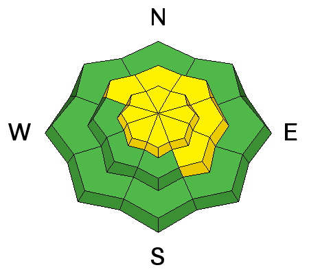
In some areas northwest winds picked up overnight, and there's lots of nice light powder on the surface, so drifting is ongoing in some upper elevation terrain. West winds and snowfall are forecast to intensify this afternoon and continue tonight, and new wind slabs will develop as others build. Wind slab avalanches are likely to become more sensitive to human triggering as the slabs build and they may release on the old snow surface or perhaps step down into weak basal snow near the ground.
|
 |
weather Snow is likely in the mountains today, mainly in the afternoon, with strengthening west wind and 3 to 7 inches of accumulation possible by evening. At 8500' high temperatures of around 18 are expected. Snow is likely to continue tonight, with a low temperature around 7 degrees, slightly stronger west wind, and a possibility of 6 to 10 additional inches of accumulation. Unsettled, wintery weather is expected to continue through the weekend and into next week, with a bit of warming on Friday and Saturday. |
| general announcements Please submit snow and avalanche observations from your ventures in the backcountry HERE. You can call us at 801-524-5304 or email HERE, or include #utavy in your Instagram or Tweet us @UAClogan. To report avalanche activity in the Logan Area or to contact the local avalanche forecaster call me, Toby, at 435-757-7578. I'll update this advisory throughout the season on Monday, Wednesday, Friday, and Saturday mornings by about 7:30 This advisory is produced by the U.S.D.A. Forest Service, which is solely responsible for its content. It describes only general avalanche conditions and local variations always exist. |