| Please join us at the 23rd annual Black Diamond Fall Fundraiser Party Thursday Sept 15. Tickets are on sale now here, at the Black Diamond store & at REI. Special bonus raffle for online ticket purchasers! |
| Please join us at the 23rd annual Black Diamond Fall Fundraiser Party Thursday Sept 15. Tickets are on sale now here, at the Black Diamond store & at REI. Special bonus raffle for online ticket purchasers! |
| Advisory: Logan Area Mountains | Issued by Toby Weed for Saturday - December 12, 2015 - 7:22am |
|---|

|
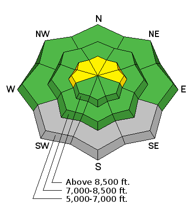
bottom line MODERATE (level 2): Pockets with heightened avalanche conditions exist, and you could trigger persistent slab avalanches in previously drifted terrain at upper elevations in the backcountry. Evaluate the snow and terrain carefully and continue to practice wise travel protocols.
|
 |
avalanche watch THE FOREST SERVICE UTAH AVALANCHE CENTER IN SALT LAKE CITY HAS ISSUED A BACKCOUNTRY AVALANCHE WATCH. * TIMING...STARTING MONDAY MORNING, DANGEROUS AVALANCHE CONDITIONS ARE EXPECTED OVER THE NEXT SEVERAL DAYS. * AFFECTED AREA...ALL THE MOUNTAINS OF NORTHERN AND CENTRAL UTAH, INCLUDING THE BEAR RIVER RANGE, THE WESTERN UINTAS AND THE WASATCH PLATEAU. * AVALANCHE DANGER...THE DANGER IS EXPECTED TO RISE SIGNIFICANTLY WITH THE ADDITIONAL SNOW AND WIND. * IMPACTS...DANGEROUS HUMAN TRIGGERED AVALANCHES ARE EXPECTED ON A VARIETY OF ASPECTS AND ELEVATIONS. |
 |
current conditions The Tony Grove Snotel at 8400' reports 26 inches of total snow containing 70% of average water content for the date and it's 20 degrees. There is a light northwest breeze at the CSI Logan Peak weather station, and it's currently 14 degrees at 9700'. I found decent shallow powder conditions yesterday in low angled terrain, but I'd sink through Tuesday's rain-rime crust into bottomless sugary or faceted snow when I got off the beaten trail or the slope got steeper. Here's a short video showing the crusty and sugary snow conditions on Thursday in the Tony Grove Area...
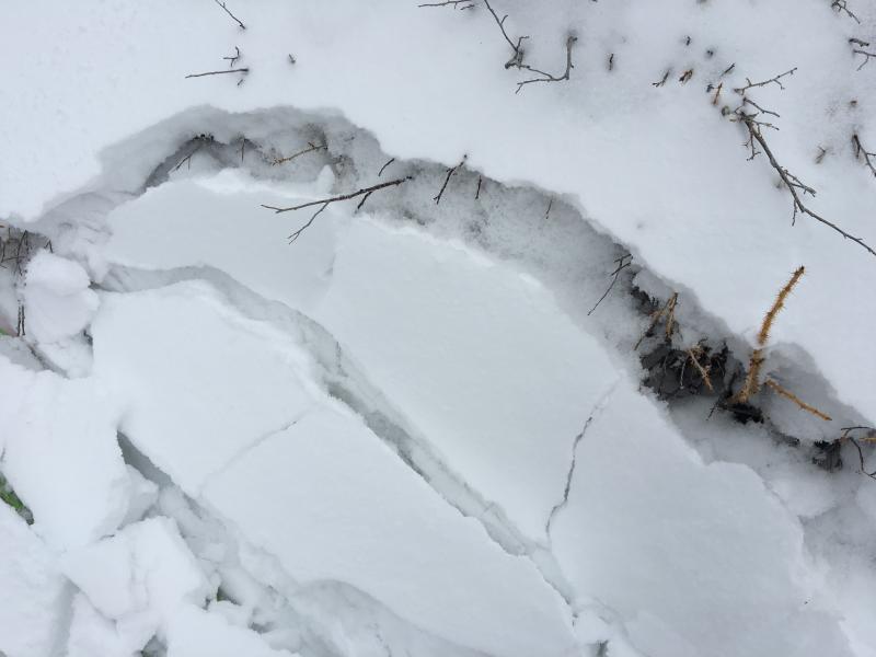
Loose faceted snow crystals plague the shallow snowpack in the Logan Zone, now capped by some powder and a few inches of plaster-like heavy snow and rime. (12-8-2015) Very shallow, early season conditions exist, and you are still likely to hit rocks or woody debris in most areas. The Tony Grove Road is not maintained in the winter for wheeled vehicles, and road conditions are icy, snowy, drifted-in and treacherous, so come prepared. As far as I could see, only sledders made it very far up the road last week. The Tony Grove Area is a shared use area and very popular in the early season, so please watch your speed, use patience, and be respectful of other users. For easier access to the shallow powder, Beaver Mt. allows uphill travel and appreciates early season users packing down the weak snow. Remember while the lifts are closed, the area is considered backcountry. It's time to dust off and check the condition of your avalanche rescue equipment. Review and practice Companion Avalanche Rescue with our video..........HERE****
|
 |
recent activity No avalanche activity has been reported in the Logan backcountry recently.
|
| type | aspect/elevation | characteristics |
|---|

|
|
LIKELIHOOD
 LIKELY
UNLIKELY
SIZE
 LARGE
SMALL
TREND
 INCREASING DANGER
SAME
DECREASING DANGER
|
|
description
In some previously drifted upper elevation areas, you could trigger wind slab avalanches that might step down into weak sugary November snow. Pockety slab distribution and shallow snow conditions indicate that potential avalanches would probably not be very wide, but they could entrain all the snow down to the rocks.
|
 |
weather Expect mostly cloudy conditions today, with 8500' high temperatures expected around 24 degrees and a north breeze. There's a chance for a little snow tonight with a low temperature around 17 degrees and increasing west southwest winds. The next Pacific storm will begin to effect our area tomorrow and continue through Monday night, with a foot or two of accumulation possible in the mountains by then. Unsettled and somewhat stormy weather will continue well into next week at least.
|
| general announcements Please submit snow and avalanche observations from your ventures in the backcountry HERE. You can call us at 801-524-5304 or email HERE, or include #utavy in your Instagram or Tweet us @UAClogan. To report avalanche activity in the Logan Area or to contact the local avalanche forecaster call me, Toby, at 435-757-7578. I'll update this advisory throughout the season on Monday, Wednesday, Friday, and Saturday mornings by about 7:30 This advisory is produced by the U.S.D.A. Forest Service, which is solely responsible for its content. It describes only general avalanche conditions and local variations always exist. |