| Please join us at the 23rd annual Black Diamond Fall Fundraiser Party Thursday Sept 15. Tickets are on sale now here, at the Black Diamond store & at REI. Special bonus raffle for online ticket purchasers! |
| Please join us at the 23rd annual Black Diamond Fall Fundraiser Party Thursday Sept 15. Tickets are on sale now here, at the Black Diamond store & at REI. Special bonus raffle for online ticket purchasers! |
| Advisory: Logan Area Mountains | Issued by Toby Weed for Wednesday - December 9, 2015 - 6:59am |
|---|

|
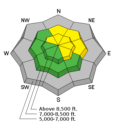
bottom line MODERATE (level 2): Heightened avalanche conditions exist in the backcountry and you could trigger wind slab avalanches in drifted terrain. Avoid travel on or below upper elevation slopes steeper than about 30 degrees with recent deposits of dense drifted snow. Avalanches could release to the ground on weak sugary snow, and it would be quite dangerous to get caught in even a small avalanche due to extremely shallow snow cover in avalanche run outs.
|
 |
current conditions A few inches of heavy snow, sustained southwest wind, rain, and mild temperatures created heightened avalanche conditions on steep slopes in the backcountry. Southwest winds increased again last night, sustaining wind speeds in the thirty mph range overnight and gusted to 45 mph early this morning at the CSI Logan Peak weather station, and it's currently 29 degrees at 9700'. It's been consistently mild, currently 36 degrees at the 8400' Tony Grove SNOTEL. The station reports 5 inches of accumulation Monday night containing an even inch of water, and there's 23 inches of total snow on the ground containing 69% of average water content for the date.
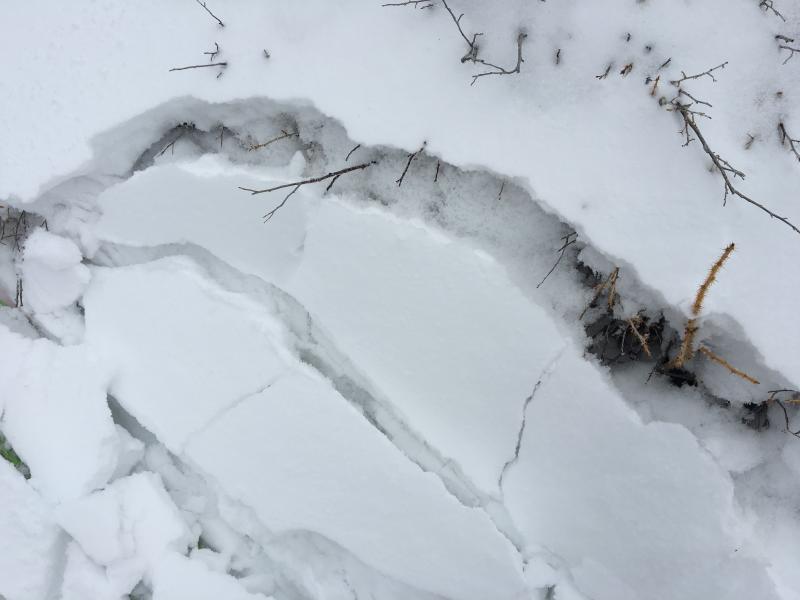
Loose faceted snow crystals plague the shallow snowpack in the Logan Zone are now capped by a few inches of plaster-like heavy snow and rime. (12-8-2015) Words of warning: Very shallow, early season conditions exist, and you are still likely to hit rocks or woody debris in most areas. The Tony Grove Road is not maintained in the winter for wheeled vehicles, and road conditions are icy, snowy, drifted-in and treacherous, so come prepared. The Tony Grove Area is a shared use area and very popular in the early season, so please watch your speed, use patience, and be respectful of other users. For easier access, Beaver Mt. allows uphill travel and appreciates early season users packing down the weak snow. Remember while the lifts are closed, the area is considered backcountry . It's time to dust off and check the condition of your avalanche rescue equipment. Review and practice Companion Avalanche Rescue with our video..........HERE****
|
 |
recent activity I noticed a couple small loose sluffs involving old faceted snow near Double Top in the Steep Hollow Area last week. There have been no other reports of avalanche activity in the Logan backcountry recently.
|
| type | aspect/elevation | characteristics |
|---|

|
|
LIKELIHOOD
 LIKELY
UNLIKELY
SIZE
 LARGE
SMALL
TREND
 INCREASING DANGER
SAME
DECREASING DANGER
|
|
description
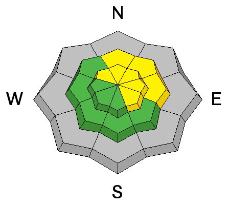
Although not enough to create much in the way of natural avalanching, Monday night's heavy snow certainly drifted into many upper elevation stating zones, and yesterday I observed fresh 1 to 1.5 foot deep drifts in many upper elevation deposition areas. The heavy and fairly strong new wind slabs built up on suspect weak faceted snow, a notorious persistent weak layer, and some may still be sensitive to triggering today. Pay attention to signs of instability like whoompfing and shooting cracks, and avoid travel on or below steep drifted slopes. |
 |
weather Expect to find windy and mild weather in the mountains again today with 8500' high temperatures around 41 degrees and continued sustained and even intensifying westerly winds. Gusts in the 50 mph range are possible. Snow is likely, but little to no accumulation is expected today or tonight and temperatures will remain quite mild. It'll be even windier tomorrow, with continuing west southwest flow, and snow is expected. 1 to 3 inches of accumulation is likely tomorrow followed by an additional 3 to 5 inches forecast for Tomorrow night. Unsettled and stormy weather will continue through the weekend and well into next week.
|
| general announcements Please submit snow and avalanche observations from your ventures in the backcountry HERE. You can call us at 801-524-5304 or email HERE, or include #utavy in your Instagram or Tweet us @UAClogan. To report avalanche activity in the Logan Area or to contact the local avalanche forecaster call me, Toby, at 435-757-7578. I'll update this advisory throughout the season on Monday, Wednesday, Friday, and Saturday mornings by about 7:30 This advisory is produced by the U.S.D.A. Forest Service, which is solely responsible for its content. It describes only general avalanche conditions and local variations always exist. |