| Please join us at the 23rd annual Black Diamond Fall Fundraiser Party Thursday Sept 15. Tickets are on sale now here, at the Black Diamond store & at REI. Special bonus raffle for online ticket purchasers! |
| Please join us at the 23rd annual Black Diamond Fall Fundraiser Party Thursday Sept 15. Tickets are on sale now here, at the Black Diamond store & at REI. Special bonus raffle for online ticket purchasers! |
| Advisory: Logan Area Mountains | Issued by Toby Weed for Tuesday - December 8, 2015 - 7:14am |
|---|

|
bottom line MODERATE (level 2): Heightened avalanche conditions exist in the backcountry and you could trigger dangerous avalanches, especially in drifted upper elevation terrain. Wet avalanches are possible on slopes with saturated snow. In these conditions you could trigger avalanches from a distance or worse, from below. Avalanches could release to the ground on weak sugary snow, and it would be quite dangerous to get caught in even a small avalanche due to extremely shallow snow cover.
|
 |
current conditions Several inches of heavy snow, sustained west wind, some overnight rain, and mild temperatures are creating heightened avalanche conditions on steep slopes in the backcountry. Southwest winds sustained wind speeds in the thirty mph range overnight and gusted to 53 mph at midnight at the CSI Logan Peak weather station, and it's currently 27 degrees at 9700'. It's been consistently mild, currently 34 degrees at the 8400' Tony Grove SNOTEL. The station reports 5 inches of accumulation overnight containing almost an inch of water and there's 23 inches of total snow on the ground containing 70% of average water content for the date. With the widespread thin and very weak snow cover you'll probably want to continue to stick to the roads, meadows, and smooth low angled terrain.
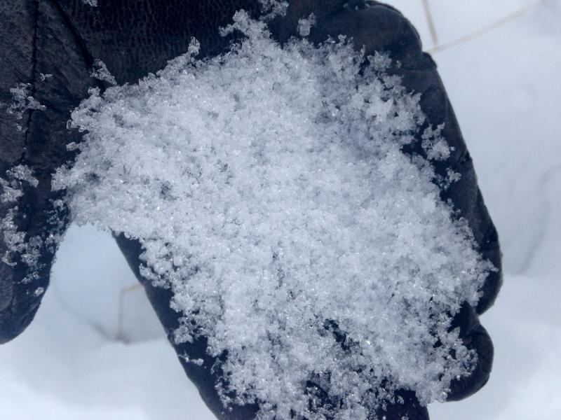
Loose faceted snow crystals plague the shallow snowpack in the Logan Zone and across Utah. (Pagnucco 12-4-2015) Words of warning: Very shallow, early season conditions exist, and you are still likely to hit rocks or woody debris in most areas. The Tony Grove Road is not maintained in the winter for wheeled vehicles, and road conditions are icy, snowy, drifted-in and treacherous, so come prepared. The Tony Grove Area is a shared use area and very popular in the early season, so please watch your speed, use patience, and be respectful of other users. For easier access, Beaver Mt. allows uphill travel and appreciates early season users packing down the weak snow. Remember while the lifts are closed, the area is considered backcountry . It's time to dust off and check the condition of your avalanche rescue equipment. Review and practice Companion Avalanche Rescue with our video..........HERE****
|
 |
recent activity I noticed a couple small loose sluffs involving old faceted snow near Double Top in the Steep Hollow Area last week. There have been no other reports of avalanche activity in the Logan backcountry recently.
|
| type | aspect/elevation | characteristics |
|---|

|
|
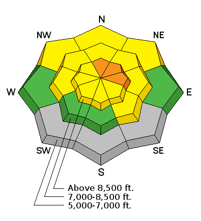
LIKELIHOOD
 LIKELY
UNLIKELY
SIZE
 LARGE
SMALL
TREND
 INCREASING DANGER
SAME
DECREASING DANGER
|
|
description
Southwest winds where strong during last night's burst of heavy snowfall.. The moist new snow was drifted into avalanche starting zones forming heavy soft slabs that are probably 1 or 2 feet thick. The new wind slabs built up on suspect weak faceted snow, and are likely to be fairly sensitive to triggering today. Pay attention to signs of instability like whoompfing and shooting cracks, and avoid travel on or below steep drifted slopes. It may be possible to trigger avalanches remotely or from a distance. |
| type | aspect/elevation | characteristics |
|---|

|
|
LIKELIHOOD
 LIKELY
UNLIKELY
SIZE
 LARGE
SMALL
TREND
 INCREASING DANGER
SAME
DECREASING DANGER
|
|
description
It looks like it rained at lower (and possibly mid) elevations and mountain temperatures will remain quite mild today. Loose wet sluffs involving very weak sugary snow are possible in steep terrain. The snow is so weak, especially on shady slopes, that wet slides entraining all the snow to the ground are possible.
|
 |
weather Expect to find breezy and mild weather in the mountains again today with 8500' high temperatures around 38 degrees and continued sustained westerly winds. Little to no accumulation is expected today or tonight and temperatures will remain quite mild. It'll be even warmer tomorrow, with intensifying southwest winds, 8500' high temperatures around 43 degrees, and snow in the afternoon. More significant snowfall is predicted for Thursday and Thursday Night.
|
| general announcements Please submit snow and avalanche observations from your ventures in the backcountry HERE. You can call us at 801-524-5304 or email HERE, or include #utavy in your Instagram or Tweet us @UAClogan. To report avalanche activity in the Logan Area or to contact the local avalanche forecaster call me, Toby, at 435-757-7578. I'll update this advisory throughout the season on Monday, Wednesday, Friday, and Saturday mornings by about 7:30 This advisory is produced by the U.S.D.A. Forest Service, which is solely responsible for its content. It describes only general avalanche conditions and local variations always exist. |