| Please join us at the 23rd annual Black Diamond Fall Fundraiser Party Thursday Sept 15. Tickets are on sale now here, at the Black Diamond store & at REI. Special bonus raffle for online ticket purchasers! |
| Please join us at the 23rd annual Black Diamond Fall Fundraiser Party Thursday Sept 15. Tickets are on sale now here, at the Black Diamond store & at REI. Special bonus raffle for online ticket purchasers! |
| Advisory: Logan Area Mountains | Issued by Toby Weed for Wednesday - December 2, 2015 - 7:22am |
|---|

|
bottom line LOW (level 1) Avalanches are unlikely on most slopes, except they're still possible in isolated steep drifted terrain at upper elevations where you might trigger old hard wind slabs releasing to the ground on weak sugary or faceted snow.
|
 |
special announcement THURSDAY NIGHT: Don't miss the 12th annual Utah Avalanche Center in Logan's "Pray for Snow" party and fundraiser, the evening of December 3, again at the Italian Place in Downtown Logan.. For info and tickets go ............HERE |
 |
current conditions It's twenty degrees this morning at the 8400' Tony Grove SNOTEL and there's 21 inches of total snow on the ground containing 69% of average water content for the date. In areas exposed to last week's wind the snow is quite variable, with evidence of significant drifting and scouring. At mid elevations and in sheltered terrain the shallow snow is mostly just "rotten" or faceted and weak to the ground. I found some nice fast shallow powder riding conditions yesterday, but with the widespread thin snow cover you'll probably want to stick to the roads, meadows, and smooth low angled terrain.
I found extensive evidence of recent strong winds in route to the Tony Grove-Blind Hollow Saddle. In terrain exposed to the wind I found fresh soft drifts up to a couple feet deep, very hard older wind slabs, areas with supportable wind-board, and areas scoured to the bone. (12-1-2015) Words of warning: Very shallow, early season conditions exist, and you are still likely to hit rocks or woody debris in most areas. The Tony Grove Road is not maintained in the winter for wheeled vehicles, and road conditions are icy, snowy, drifted-in and treacherous, so come prepared. The Tony Grove Area is a shared use area and very popular in the early season, so please watch your speed, use patience, and be respectful of other users. For easier access, Beaver Mt. allows uphill travel and appreciates early season users packing down the weak snow. Remember while the lifts are closed, the area is considered backcountry . It's time to dust off and check the condition of your avalanche rescue equipment. Review and practice Companion Avalanche Rescue with our video..........HERE****
|
 |
recent activity No avalanches were reported locally since November 20, when we picked up a foot of heavy snow containing 2.5 inches of water and several natural avalanches occurred, as well as one above the Tony Grove Campground, remote triggered by a skier which sympathetically released an adjacent pocket. I could see evidence of some recent natural shallow wind slab activity in the Tony Grove Area from earlier in the week.
|
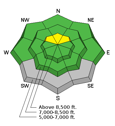
| type | aspect/elevation | characteristics |
|---|

|
|
LIKELIHOOD
 LIKELY
UNLIKELY
SIZE
 LARGE
SMALL
TREND
 INCREASING DANGER
SAME
DECREASING DANGER
|
|
description
Hard wind slabs formed in somewhat unusual places with the very strong and sustained east winds around Thanksgiving, and I found some fresher soft drifts from early this week consisting of the more recent colder snow. The old hard slabs are relaxed and no longer very sensitive, but some in more extreme terrain may be like large mouse traps and may wait until you get well out on them before releasing on weak snow near the ground. |
 |
weather Expect increasing cloudiness today with southwest winds around 10 mph along the ridges. It'll be mostly cloudy tonight with a low of around 19 degrees at 8500'. Looks like it'll get pretty warm tomorrow in the mountains, with partly sunny conditions and high temperatures around 40 degrees. Some snow accumulation is possible Friday and Friday night, but don't get your hopes up, because it doesn't look like much. |
| general announcements Please submit snow and avalanche observations from your ventures in the backcountry HERE. You can call us at 801-524-5304 or email HERE, or include #utavy in your Instagram or Tweet us @UAClogan. To report avalanche activity in the Logan Area or to contact the local avalanche forecaster call me, Toby, at 435-757-7578. I'll update this advisory throughout the season on Monday, Wednesday, Friday, and Saturday mornings by about 7:30 This advisory is produced by the U.S.D.A. Forest Service, which is solely responsible for its content. It describes only general avalanche conditions and local variations always exist. |


