| Please join us at the 23rd annual Black Diamond Fall Fundraiser Party Thursday Sept 15. Tickets are on sale now here, at the Black Diamond store & at REI. Special bonus raffle for online ticket purchasers! |
| Please join us at the 23rd annual Black Diamond Fall Fundraiser Party Thursday Sept 15. Tickets are on sale now here, at the Black Diamond store & at REI. Special bonus raffle for online ticket purchasers! |
| Advisory: Logan Area Mountains | Issued by Mark Staples for Friday - November 27, 2015 - 6:08am |
|---|

|
bottom line Triggering a freshly formed wind slab is likely today. These wind slabs should remain sensitive through the weekend because they rest on weak, faceted snow. With shallow snow conditions, an avalanche may not bury you but cause serious trauma as it carries you over rocks, stumps and deadfall.
|
 |
special announcement Join us for a free avalanche awareness talk with the USU Outdoor Recreation Program at 7:00 on December 1..... USU ORP classes Don't miss the 12th annual Utah Avalanche Center in Logan's "Pray for Snow" party and fundraiser, the evening of December 3, again at the Italian Place in Downtown Logan.. For info and tickets go ............HERE |
 |
current conditions Cold east winds pushed temperatures into the single digits F this morning. At Logan Peak winds were averaging 45 mph from the east. Two days ago, on Wednesday evening, 6 inches of new snow fell at the Tony Grove SNOTEL site and 10 inches fell at the Monte Cristo SNOTEL site. Prior this snowfall Toby, Drew and I looked at recent avalanches from last weekend near Tony Grove, and we were surprised how weak and faceted the snow surface had become. Wednesday’s snow buried these facets. This morning and overnight, east winds likely transported this new snow and formed slabs in strange or unexpected places. Because these wind slabs rest on facets, they will be easy to trigger and cause an avalanche. In places without a wind slab, I do not think there is enough new snow to cause an avalanche problem. Near the end of the video below, pay attention to how loose and faceted the surface snow is as Toby scoops it with his hands.
Words of warning: Very shallow, early season conditions exist, and you are still likely to hit rocks or woody debris in most areas. The Tony Grove Road is not maintained in the winter for wheeled vehicles, and road conditions are icy, snowy, drifted-in and treacherous, so come prepared. The upper section of the road and the loop at the lake were impassible over the weekend. The Tony Grove Area is a shared use area and very popular in the early season, so please watch your speed, use patience, and be respectful of other users. For easier access, Beaver Mt. allows uphill travel and appreciates early season users packing down the weak snow. Remember while the lifts are closed, the area is considered backcountry . It's time to dust off and check the condition of your avalanche rescue equipment. Review and practice Companion Avalanche Rescue with our video..........HERE****
|
 |
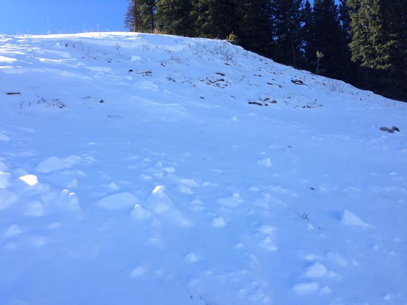
recent activity Natural and remote triggered storm and/or persistent slab activity occurred in the Tony Grove Area Friday, 11-22-15 after heavy snowfall containing around 2.5" of water.
This avalanche on a steep north facing slope above the Tony Grove Campground and near Beginner Bowl was probably remotely triggered by a skier Friday. (11-20-2015). At the same time another avalanche about 300 feet wide sympathetically released just out of view of this photo in the trees. |
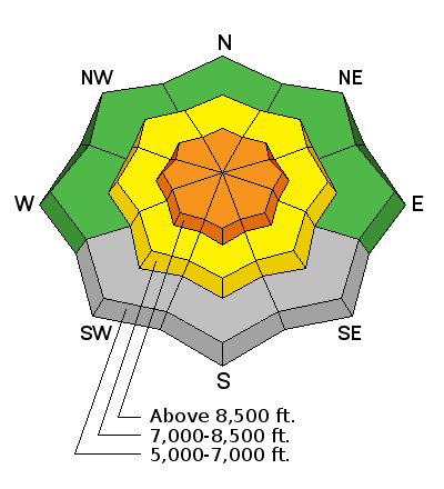
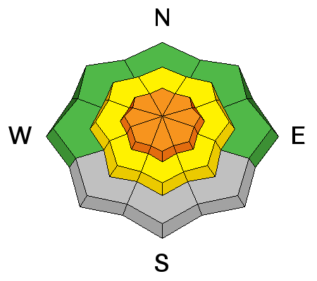
| type | aspect/elevation | characteristics |
|---|

|
|
LIKELIHOOD
 LIKELY
UNLIKELY
SIZE
 LARGE
SMALL
TREND
 INCREASING DANGER
SAME
DECREASING DANGER
|
|
description
6-10 inches of low density snow plus strong east winds should create fresh wind slabs this morning in strange or unexpected places. These wind slabs should be easy to trigger because they rest on a layer of weak, sugary facets that formed last weekend during warm sunny days and clear cold nights. |
 |
weather With an area of low pressure spinning over Utah, east winds should keep temperatures cold today; however, winds should calm through the day. Depending on how much skies clear, temperatures should rise into the high teens or low 20s F today. More snow should come tonight and through the weekend. Don't get too excited. Only a few snowflakes should fall tonight and and inch or two at best should fall tomorrow. A little more snow is possible for Sunday. High pressure and dry conditions are forecasted for next week. |
| general announcements Please submit snow and avalanche observations from your ventures in the backcountry HERE. You can call us at 801-524-5304 or email HERE, or include #utavy in your Instagram or Tweet us @UAClogan. To report avalanche activity in the Logan Area or to contact the local avalanche forecaster call me, Toby, at 435-757-7578. This advisory is produced by the U.S.D.A. Forest Service, which is solely responsible for its content. It describes only general avalanche conditions and local variations always exist. |