| Please join us at the 23rd annual Black Diamond Fall Fundraiser Party Thursday Sept 15. Tickets are on sale now here, at the Black Diamond store & at REI. Special bonus raffle for online ticket purchasers! |
| Please join us at the 23rd annual Black Diamond Fall Fundraiser Party Thursday Sept 15. Tickets are on sale now here, at the Black Diamond store & at REI. Special bonus raffle for online ticket purchasers! |
| Advisory: Logan Area Mountains | Issued by Toby Weed for Friday - November 20, 2015 - 7:18am |
|---|

|
bottom line There's a CONSIDERABLE (level 3) danger at upper elevations in the backcountry, and dangerous avalanche conditions exist on drifted slopes. You are likely to trigger dangerous wind slab or persistent slab avalanches on slopes steeper than about 35 degrees with significant recent deposits of drifted snow. Avalanches are possible in drifted mid-elevation terrain as well, and shallow snow conditions mean a ride in any avalanche could be traumatic, with rocks and down trees adding to the danger. Avoid steep drifted terrain and use wise travel protocols.
|
 |
special announcement Don't miss the 12th annual Utah Avalanche Center in Logan's "Pray for Snow" party and fundraiser, the evening of December 3, again at the Italian Place in Downtown Logan.. For info and tickets go ............HERE |
 |
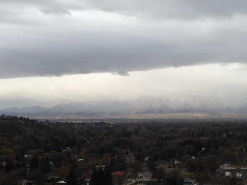
current conditions Heavy snow and strong, sustained westerly winds yesterday and overnight have created dangerous avalanche conditions at upper elevations. The Tony Grove Snotel at 8400' reports 11" of new snow containing 2.4" of water equivalent in the last 24 hours and the CSI Logan Peak weather station at 9700' reports sustained southwest winds overnight, averaging in the mid twenties with a 43 mph gust early this morning. Temperatures are now dropping and the winds are veering from the northwest after the frontal passage early this morning. An observer reports triggering numerous audible collapses late yesterday afternoon in the Tony Grove Area indicating unstable snow.
Words of warning: Very shallow, early season conditions exist, and you are still likely to hit rocks or woody debris in most areas. The Tony Grove Road is not maintained in the winter for wheeled vehicles, and road conditions are icy, snowy, drifted-in and treacherous, so come prepared. The Tony Grove Area is a shared use area and very popular in the early season, so please watch your speed, use patience, and be respectful of other users. It's time to dust off and check the condition of your avalanche rescue equipment. Review and practice Companion Avalanche Rescue with our video..........HERE****
|
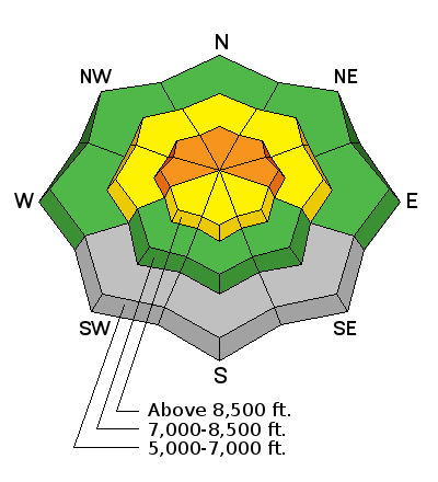
| type | aspect/elevation | characteristics |
|---|

|

|
LIKELIHOOD
 LIKELY
UNLIKELY
SIZE
 LARGE
SMALL
TREND
 INCREASING DANGER
SAME
DECREASING DANGER
|
|
description
You are likely to trigger fresh wind slabs 1 to 2 feet deep on steep drifted slopes at upper elevations, and some natural avalanche activity is possible. Strong southwest winds accompanied last night's heavy snowfall, and significant drifting resulted. Suspect large drifts on the lee side of ridge lines and terrain features where drifted snow was deposited like gully walls, cliff bands, mid-slope roll-overs, scoops. Avoid and stay out from under stiffer drifted snow on steep slopes Due to the shallow snow conditions, a ride in even a small avalanche could be traumatic. |
| type | aspect/elevation | characteristics |
|---|

|

|
LIKELIHOOD
 LIKELY
UNLIKELY
SIZE
LARGE
SMALL
TREND
 INCREASING DANGER
SAME
DECREASING DANGER
|
|
description
The shallow snow on the ground for the past couple week's has become faceted and weak due to a strong temperature gradient. Reports of audible collapsing yesterday afternoon in the Tony Grove Area confirm the existence of unstable snow, (weak sugary snow on the ground and heavy fresh snow creating a slab on top). Freshly formed and built up wind slabs are likely to fail on the weak underlying snow, a problem that is likely to haunt us for a while. |
 |
weather It'll be very windy in the mountains today, with northwest winds cranking along the ridges and gusting into the 43 mph range. High temperatures in the mountains are expected around 24 degrees today and there's a chance for around an inch of accumulation this morning. Expect clearing in the afternoon and decreasing wind. It'll be mostly clear tonight, with light north winds and 8500' temperatures around 8 degrees. Expect fair and clear weather through the weekend and into early next week. A "long duration" period of snowy and unsettled weather is expected in the days around the Thanksgiving holiday.... |
| general announcements Please submit snow and avalanche observations from your ventures in the backcountry HERE. You can call us at 801-524-5304 or email HERE, or include #utavy in your Instagram or Tweet us @UAClogan. To report avalanche activity in the Logan Area or to contact the local avalanche forecaster call me, Toby, at 435-757-7578. This advisory is produced by the U.S.D.A. Forest Service, which is solely responsible for its content. It describes only general avalanche conditions and local variations always exist. |