| Please join us at the 23rd annual Black Diamond Fall Fundraiser Party Thursday Sept 15. Tickets are on sale now here, at the Black Diamond store & at REI. Special bonus raffle for online ticket purchasers! |
| Please join us at the 23rd annual Black Diamond Fall Fundraiser Party Thursday Sept 15. Tickets are on sale now here, at the Black Diamond store & at REI. Special bonus raffle for online ticket purchasers! |
| Advisory: Logan Area Mountains | Issued by Toby Weed for Thursday - November 12, 2015 - 6:59am |
|---|

|
bottom line The danger in the backcountry is LOW and avalanches are unlikely. Even so, you should avoid drifted terrain at upper elevations where you might trigger isolated shallow wind slab avalanches. Given the shallow snow conditions and abundant rocks and down trees in the area, a ride in even a small avalanche could be quite dangerous.
|
 |
special announcement Don't miss the 12th annual Utah Avalanche Center in Logan's "Pray for Snow" party and fundraiser, the evening of December 3, again at the Italian Place in Downtown Logan.. For info and tickets go ............HERE |
 |
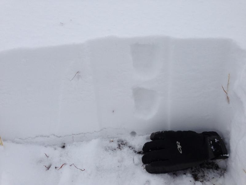
current conditions We found around 6" of fresh accumulation at Tony Grove Lake yesterday, and there's about a foot of total snow on the ground above around 8500' in elevation. There's still not enough snow on most slopes for avalanche problems, with possible exceptions at the highest elevations where drifting snow will likely create fresh shallow wind slabs. We are closely watching the shallow snow on the ground, with facet forming high pressure weather conditions expected for the coming weekend.
There's about a foot of snow at 8700' in the Tony Grove Area, and a bit more on some higher drifted slopes Words of warning: Very shallow, early season conditions exist, and you are likely to hit rocks or woody debris in most areas. The Tony Grove Road is not maintained in the winter for wheeled vehicles, and road conditions are likely to be treacherous, so come prepared. The Tony Grove Area is a shared use area and very popular in the early season, so please watch your speed, use patience, and be respectful of other users. Snow is starting to pile up at higher elevations, so it's time to dust off and check the condition of your avalanche rescue equipment. Review and practice Companion Avalanche Rescue with our video..........HERE****
|
| type | aspect/elevation | characteristics |
|---|

|

|
LIKELIHOOD
 LIKELY
UNLIKELY
SIZE
 LARGE
SMALL
TREND
 INCREASING DANGER
SAME
DECREASING DANGER
|
|
description
Avalanches are unlikely with the still very slim snow cover, but you might find some exceptions in smooth upper elevation terrain exposed to wind drifting, and in some isolated areas you could trigger shallow wind slab avalanches. Due to the shallow snow conditions, a ride in even a small avalanche could be traumatic. |
 |
weather A storm system passing to the north will graze the zone today, but little accumulation is expected. Expect mostly cloudy conditions today, becoming sunny in the afternoon. High temperatures at 8500' are expected around 28 degrees, and we can expect light to moderate west winds on the ridges. High pressure conditions will build for the weekend, with the next storm expected Sunday night into Monday. |
| general announcements Please submit snow and avalanche observations from your ventures in the backcountry HERE. You can call us at 801-524-5304 or email HERE, or include #utavy in your Instagram or Tweet us @UAClogan. To report avalanche activity in the Logan Area or to contact the local avalanche forecaster call me, Toby, at 435-757-7578.
This advisory is produced by the U.S.D.A. Forest Service, which is solely responsible for its content. It describes only general avalanche conditions and local variations always exist. |