| Please join us at the 23rd annual Black Diamond Fall Fundraiser Party Thursday Sept 15. Tickets are on sale now here, at the Black Diamond store & at REI. Special bonus raffle for online ticket purchasers! |
| Please join us at the 23rd annual Black Diamond Fall Fundraiser Party Thursday Sept 15. Tickets are on sale now here, at the Black Diamond store & at REI. Special bonus raffle for online ticket purchasers! |
| Advisory: Logan Area Mountains | Issued by Toby Weed for Friday - November 6, 2015 - 6:23pm |
|---|

|
bottom line The danger in the backcountry is LOW and avalanches are unlikely this weekend. Even so, you still might trigger isolated shallow wind slab avalanches in windy or exposed terrain at the highest elevations.
|
 |
special announcement Don't miss the 12th annual Utah Avalanche Center in Logan's "Pray for Snow" party and fundraiser, the evening of December 3, again at the Italian Place in Downtown Logan.. For info and tickets go ............HERE |
 |
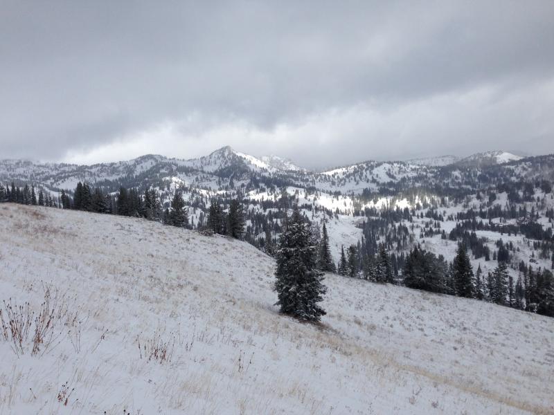
current conditions A good amount of fresh, somewhat dense and rimed new snow including some graupel fell in the last couple days at upper elevations in the Logan Zone . We found around 6" of fresh accumulation at Tony Grove Lake today, but more like a foot in Beginner Bowl and above around 8500' in elevation. Under the fresh snow from the last couple days, we found a thin layer of harder snow (5-10 cm) capping the still warm and soft ground on a north facing slope.
There's about a foot of snow at 8700' in the Tony Grove Area, more on some higher drifted slopes Words of warning: Very shallow, early season conditions exist, and you are likely to hit rocks or woody debris in most areas. The Tony Grove Road is not maintained in the winter for wheeled vehicles, and road conditions are likely to be treacherous. Snow is starting to pile up at higher elevations, so it's time to dust off and check the condition of your avalanche rescue equipment. Review and practice Companion Avalanche Rescue with our video..........HERE****
|
| type | aspect/elevation | characteristics |
|---|

|
|
LIKELIHOOD
 LIKELY
UNLIKELY
SIZE
 LARGE
SMALL
TREND
 INCREASING DANGER
SAME
DECREASING DANGER
|
|
description
This is the first significant accumulation this season, and the fresh snow should stick well to the rough underlying terrain. Avalanches are unlikely, but you might find some exceptions in smooth upper elevation terrain exposed to wind drifting, and in some isolated areas you could trigger shallow wind slab avalanches. Due to the shallow snow conditions, a ride in even a small avalanche could be traumatic. |
 |
weather Looks like a high pressure system will build tonight, promising pleasant and reasonably cool weather for the weekend. The next storm will move through the zone on Monday and 3 to 7 inches of accumulation is forecast for the mountains by Tuesday morning. The outlook is pretty good for another, stronger storm late next week. |
| general announcements Please continue to submit snow and avalanche observations from your ventures in the backcountry HERE. You can call us at 801-524-5304 or email HERE, or include #utavy in your Instagram or Tweet us @UAClogan. To report avalanche activity in the Logan Area or to contact the local avalanche forecaster call me, Toby, at 435-757-7578. Many thanks to YOU, Region 4 of the Forest Service, the Uinta-Wasatch-Cache National Forest, the Logan Ranger District, our supporters and partners, and the Friends of the Utah Avalanche Center, for making these advisories and the very existence of the Utah Avalanche Center in Logan possible. This advisory is produced by the U.S.D.A. Forest Service, which is solely responsible for its content. It describes only general avalanche conditions and local variations always exist. |