| Please join us at the 23rd annual Black Diamond Fall Fundraiser Party Thursday Sept 15. Tickets are on sale now here, at the Black Diamond store & at REI. Special bonus raffle for online ticket purchasers! |
| Please join us at the 23rd annual Black Diamond Fall Fundraiser Party Thursday Sept 15. Tickets are on sale now here, at the Black Diamond store & at REI. Special bonus raffle for online ticket purchasers! |
| Advisory: Abajo Area Mountains | Issued by Eric Trenbeath for Monday - April 4, 2016 - 7:20am |
|---|

|
bottom line The avalanche danger is generally LOW but unstable snow may exist on isolated terrain features. As the days heat up, continue to watch for signs of wet snow instability such as roller balls, pinwheels, and sloppy wet snow, and stay off of and out from under steep slopes when these signs are present. In areas of more extreme radical terrain, it may still be possible to trigger an errant wind slab, or have a cornice break off beneath you. Continue to practice safe travel techniques and carry appropriate rescue gear.
|
 |
special announcement The Abajo / Blue Mountain advisory provides detailed snow, mountain weather, and avalanche information on weekends. During the week, an overall danger rating will be provided with current condition information available through the weather links below. The last advisory for the season will be posted on Saturday, April 9. |
 |
current conditions Winds, temperature and humidity on Abajo Peak. Snow totals at Buckboard Flat. Snow totals at Camp Jackson.
|
 |
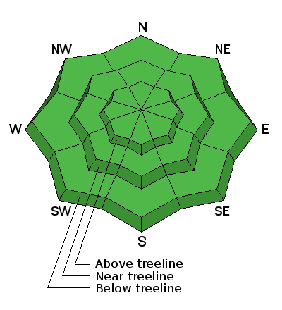
recent activity
|
| type | aspect/elevation | characteristics |
|---|

|
|
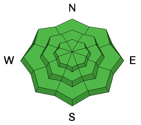
LIKELIHOOD
 LIKELY
UNLIKELY
SIZE
 LARGE
SMALL
TREND
 INCREASING DANGER
SAME
DECREASING DANGER
|
|
description
|
 |
weather Monday will be another beautiful day in the mountains. On Tuesday, a fast moving and weakening system will clip by to the north bringing clouds, gusty winds, and a slight chance for snow. Sunny skies return on Wednesday, with another system looming for the weekend. Today Mostly sunny, with a high near 45. South southwest wind 10 to 15 mph, with gusts as high as 25 mph. Tonight Partly cloudy, with a low around 31. Southwest wind 10 to 15 mph becoming northwest after midnight. Tuesday Mostly sunny, with a high near 38. Windy, with a northwest wind 15 to 20 mph increasing to 25 to 30 mph in the afternoon. Winds could gust as high as 50 mph. Tuesday Night Mostly clear, with a low around 24. Windy, with a north northwest wind 25 to 30 mph becoming north 15 to 20 mph after midnight. Winds could gust as high as 50 mph. Wednesday Sunny, with a high near 40. North wind 10 to 15 mph becoming south in the afternoon. Wednesday Night Mostly clear, with a low around 30. Thursday Sunny, with a high near 48. Thursday Night Partly cloudy, with a low around 34. Friday A chance of snow showers, mainly after noon. Partly sunny, with a high near 44. |
| general announcements Let me know what you are seeing down there by posting an observation here. You can also call me on my cell phone at 801-647-8896 To receive this advisory by email go here. This information does not apply to developed ski areas or highways where avalanche control is normally done. This advisory is from the U.S.D.A. Forest Service, which is solely responsible for its content. This advisory describes general avalanche conditions and local variations always exist. |


