| Please join us at the 23rd annual Black Diamond Fall Fundraiser Party Thursday Sept 15. Tickets are on sale now here, at the Black Diamond store & at REI. Special bonus raffle for online ticket purchasers! |
| Please join us at the 23rd annual Black Diamond Fall Fundraiser Party Thursday Sept 15. Tickets are on sale now here, at the Black Diamond store & at REI. Special bonus raffle for online ticket purchasers! |
| Advisory: Abajo Area Mountains | Issued by Eric Trenbeath for Saturday - March 19, 2016 - 7:12am |
|---|

|
bottom line Overall, the avalanche danger is generally LOW but unstable snow may exist on isolated terrain features, particularly in upper elevation, steep and radical terrain.
|
 |
special announcement The Abajo / Blue Mountain advisory provides detailed snow, mountain weather, and avalanche information on weekends. During the week, an overall danger rating will be provided with current condition information available through the weather links below. Please help guide our discussions of website maintenance, upgrades or possible changes in coming years. Take this brief survey. As a way of saying thanks we'll be raffling a free avalanche class and other free stuff like hats, beanies, water bottles, etc
|
 |
current conditions
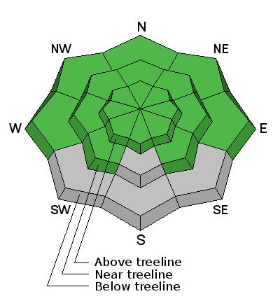
It's spring in the Abajos and the snowline is creeping higher. Many south facing slopes are melted out entirely. Buckboard Flat still has a base depth of 30" and sheltered, north facing aspects have about 4' of coverage but between the wind, sun, and unusually dry February, and as of yet March, things are going fast. Most snow surfaces have some degree of melt freeze crust going on, and only the highest, northerly aspects hold any dry snow. It's just above freezing at Buckboard Flat this morning, and temperatures are in the mid 20's on Abajo Peak. Winds are moderate and westerly. Winds, temperature and humidity on Abajo Peak. Snow totals at Buckboard Flat. Snow totals at Camp Jackson.
|
 |
recent activity
|
| type | aspect/elevation | characteristics |
|---|

|
|
LIKELIHOOD
 LIKELY
UNLIKELY
SIZE
 LARGE
SMALL
TREND
 INCREASING DANGER
SAME
DECREASING DANGER
|
|
description
The avalanche danger is mostly low at this time. But low danger doesn't mean no danger and areas of unstable snow may still exist on isolated terrain features. Here are problems to remain aware of: Wind Slabs: Isolated wind slabs may still exist on the lee sides of ridge crests and terrain features in upper elevation, wind exposed terrain, primarily on slopes with a N-NE-E aspect. Persistent Slabs: It may still be possible to trigger a slab on weak sugary, faceted snow in areas of steep, rocky, and more extreme northerly facing terrain. Slide paths that are repeat runners are also suspect. Loose wet avalanches: Daytime heating can make the snow wet and sloppy and prone to avalanching. Look for signs off instability such as rollerballs, pinwheels, or wet sluffs sliding down the slope. Stay off of and out from under steep slopes when these signs are present.
|
 |
weather Sunny and breezy conditions are in store for the weekend. Temperatures will climb higher each day to near 50 degrees at 10,000' by Monday. A storm system that looks to affect mainly areas to the north will move into the region on Tuesday night. Today Sunny, with a high near 36. Breezy, with a north northwest wind 15 to 20 mph, with gusts as high as 35 mph. Tonight Mostly clear, with a low around 25. Blustery, with a north northwest wind 15 to 20 mph, with gusts as high as 30 mph. Sunday Sunny, with a high near 44. North northwest wind around 15 mph becoming south southwest in the morning. Winds could gust as high as 30 mph. Sunday Night Mostly clear, with a low around 33. Breezy, with a southwest wind 15 to 20 mph, with gusts as high as 35 mph. Monday Mostly sunny, with a high near 50. Breezy, with a southwest wind 15 to 25 mph, with gusts as high as 45 mph. |
| general announcements Let me know what you are seeing down there by posting an observation here. You can also call me on my cell phone at 801-647-8896 To receive this advisory by email go here. This information does not apply to developed ski areas or highways where avalanche control is normally done. This advisory is from the U.S.D.A. Forest Service, which is solely responsible for its content. This advisory describes general avalanche conditions and local variations always exist. |


