| Please join us at the 23rd annual Black Diamond Fall Fundraiser Party Thursday Sept 15. Tickets are on sale now here, at the Black Diamond store & at REI. Special bonus raffle for online ticket purchasers! |
| Please join us at the 23rd annual Black Diamond Fall Fundraiser Party Thursday Sept 15. Tickets are on sale now here, at the Black Diamond store & at REI. Special bonus raffle for online ticket purchasers! |
| Advisory: Abajo Area Mountains | Issued by Eric Trenbeath for Wednesday - March 16, 2016 - 6:50am |
|---|

|
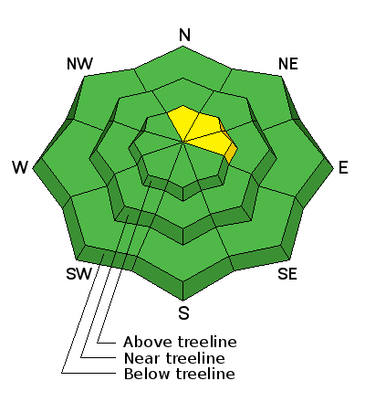
bottom line Overall, the avalanche danger is generally LOW but unstable snow may exist on isolated terrain features in upper elevation, steep and radical terrain, that has a N-NE-E aspect.
|
 |
special announcement The Abajo / Blue Mountain advisory provides detailed snow, mountain weather, and avalanche information on weekends. During the week, an overall danger rating will be provided with current condition information available through the weather links below. Please help guide our discussions of website maintenance, upgrades or possible changes in coming years. Take this brief survey. As a way of saying thanks we'll be raffling a free avalanche class and other free stuff like hats, beanies, water bottles, etc
|
 |
current conditions A storm system on Monday left trace amounts of snow and produced strong west southwest winds. Expect to find a mix of wind and sun damaged snow and possibly isolated, shallow wind slabs in upper elevation terrain. Many south facing slopes are melted out to the ground. Winds, temperature and humidity on Abajo Peak. Snow totals at Buckboard Flat. Snow totals at Camp Jackson.
|
 |
recent activity
|
| type | aspect/elevation | characteristics |
|---|

|
|
LIKELIHOOD
 LIKELY
UNLIKELY
SIZE
 LARGE
SMALL
TREND
 INCREASING DANGER
SAME
DECREASING DANGER
|
|
description
The avalanche danger is mostly low at this time. But low danger means that problems may still exist on isolated terrain features. Here are a few problems to remain aware of: Wind Slabs: Isolated wind slabs may still exist on the lee sides of ridge crests and terrain features in upper elevation, wind exposed terrain, primarily on slopes with a N-NE-E aspect. Persistent Slabs: It may still be possible to trigger a slab on weak sugary, faceted snow in areas of steep, rocky, and more extreme northerly facing terrain. Slide paths that are repeat runners are also suspect.
|
 |
weather Wednesday Mostly sunny, with a high near 36. Breezy, with a northwest wind 20 to 25 mph, with gusts as high as 40 mph. Wednesday Night Mostly clear, with a low around 25. Blustery, with a northwest wind 15 to 20 mph, with gusts as high as 35 mph. Thursday Sunny, with a high near 40. Northwest wind around 15 mph. Thursday Night Mostly clear, with a low around 23. Friday Sunny, with a high near 33. Friday Night Mostly clear, with a low around 21. Saturday Sunny, with a high near 37. Saturday Night Mostly clear, with a low around 27. Sunday Sunny, with a high near 42. |
| general announcements Let me know what you are seeing down there by posting an observation here. You can also call me on my cell phone at 801-647-8896 To receive this advisory by email go here. This information does not apply to developed ski areas or highways where avalanche control is normally done. This advisory is from the U.S.D.A. Forest Service, which is solely responsible for its content. This advisory describes general avalanche conditions and local variations always exist. |


