| Please join us at the 23rd annual Black Diamond Fall Fundraiser Party Thursday Sept 15. Tickets are on sale now here, at the Black Diamond store & at REI. Special bonus raffle for online ticket purchasers! |
| Please join us at the 23rd annual Black Diamond Fall Fundraiser Party Thursday Sept 15. Tickets are on sale now here, at the Black Diamond store & at REI. Special bonus raffle for online ticket purchasers! |
| Advisory: Abajo Area Mountains | Issued by Eric Trenbeath for Saturday - March 12, 2016 - 6:52am |
|---|

|
bottom line
|
 |
special announcement The Abajo / Blue Mountain advisory provides detailed snow, mountain weather, and avalanche information on weekends. During the week, an overall danger rating will be provided with current condition information available through the weather links below. Confused about danger ratings and how to apply them to your terrain choices? Check out this great video produced by the USFS National Avalanche Center.
|
 |
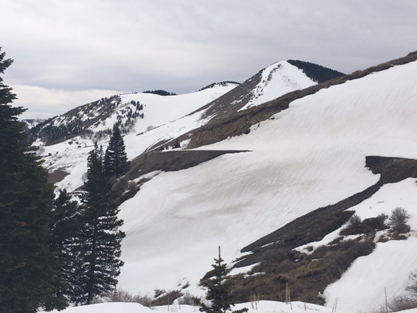
current conditions Things are looking a little tired and worn down in the Abajo/Blue Mountains. South facing slopes are nearly melted out, and the existing snow surface is mostly crusted over. Some soft powder-like conditions can still be found in sheltered, shady aspects. It's blustery out there today with SSE winds blowing in the 20-30 mph range. Temperatures have been steadily dropping overnight, and it's currently only 20 degrees on Abajo Peak, and right around freezing at Buckboard Flat.
Winds, temperature and humidity on Abajo Peak. Snow totals at Buckboard Flat. Snow totals at Camp Jackson.
|
 |
recent activity
|
| type | aspect/elevation | characteristics |
|---|

|
|
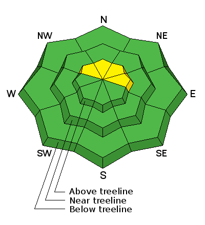
LIKELIHOOD
 LIKELY
UNLIKELY
SIZE
 LARGE
SMALL
TREND
 INCREASING DANGER
SAME
DECREASING DANGER
|
|
description
With a little bit of snow in the forecast, along with the kind of winds we've been having, we may some some shallow wind slabs developing on the lee sides of upper elevation ridge crests and terrain features today. They aren't likely to pose much of a problem, especially if you are on a sled, but they'll be worth noting if not just for a point of interest. |
 |
weather A weak system will move through the 4 Corners later today, bringing us mostly cloudy skies by this afternoon and maybe and inch or two of snow. Skies will clear by tomorrow as the system moves on. By Monday, another weak system on a westerly flow offers another chance at snow. Today Snow showers, mainly before 3pm. High near 36. Breezy, with a south southwest wind 15 to 20 mph becoming west northwest in the afternoon. Chance of precipitation is 80%. Total daytime snow accumulation of 1 to 2 inches possible. Tonight A 30 percent chance of snow showers, mainly before 7pm. Partly cloudy, with a low around 26. Blustery, with a north northwest wind 20 to 25 mph, with gusts as high as 35 mph. Sunday Mostly sunny, with a high near 38. West northwest wind around 15 mph becoming southwest in the morning. Sunday Night A 20 percent chance of snow after 11pm. Mostly cloudy, with a low around 27. Breezy, with a southwest wind 20 to 25 mph. Monday Snow likely, mainly after 11am. Mostly cloudy, with a high near 36. Breezy, with a west southwest wind 20 to 25 mph, with gusts as high as 45 mph. Chance of |
| general announcements Let me know what you are seeing down there by posting an observation here. You can also call me on my cell phone at 801-647-8896 To receive this advisory by email go here. This information does not apply to developed ski areas or highways where avalanche control is normally done. This advisory is from the U.S.D.A. Forest Service, which is solely responsible for its content. This advisory describes general avalanche conditions and local variations always exist. |