| Please join us at the 23rd annual Black Diamond Fall Fundraiser Party Thursday Sept 15. Tickets are on sale now here, at the Black Diamond store & at REI. Special bonus raffle for online ticket purchasers! |
| Please join us at the 23rd annual Black Diamond Fall Fundraiser Party Thursday Sept 15. Tickets are on sale now here, at the Black Diamond store & at REI. Special bonus raffle for online ticket purchasers! |
| Advisory: Abajo Area Mountains | Issued by Eric Trenbeath for Friday - March 11, 2016 - 7:26am |
|---|

|
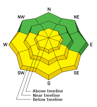
bottom line With daytime heating, the danger will rise to MODERATE on sun exposed slopes. Look for signs of instability such as roller balls or pinwheels, and sloppy wet snow. Get off of, and stay out from under sun exposed slopes when these signs are present. There also remains a MODERATE avalanche danger on steep upper elevation, wind drifted terrain, primarily on slopes with a NW-N-E aspect where it is possible to trigger a wind slab or persistent slab down to weak, shallow, sugary snow. Terrain choices are key - suspect slopes with steep convexities and be leery of rocky and more radical terrain.
|
 |
special announcement The Abajo / Blue Mountain advisory provides detailed snow, mountain weather, and avalanche information on weekends. During the week, an overall danger rating will be provided with current condition information available through the weather links below.
|
 |
current conditions Winds, temperature and humidity on Abajo Peak. Snow totals at Buckboard Flat. Snow totals at Camp Jackson.
|
 |
recent activity
|
 |
weather Temperatures will again soar into the mid 40's today around 10,000'. Southwest winds will be on the increase ahead of a storm tracking south into Arizona and New Mexico. Clouds will begin to move in tonight with mostly cloudy skies and a slight chance for snow on Saturday. Sunday looks to be mostly sunny ahead of a moist pattern setting up for next week. Today Mostly sunny, with a high near 44. Windy, with a south wind 15 to 20 mph increasing to 25 to 30 mph in the afternoon. Winds could gust as high as 40 mph. Tonight Partly cloudy, with a low around 30. Windy, with a south wind 25 to 30 mph, with gusts as high as 45 mph. Saturday Snow likely, mainly between 8am and 11am, then a chance of snow showers after 11am. Mostly cloudy, with a high near 38. Breezy, with a south wind 15 to 25 mph becoming west northwest in the afternoon. Chance of precipitation is 60%. New snow accumulation of around an inch possible. Saturday Night Partly cloudy, with a low around 28. Northwest wind around 15 mph. Sunday Mostly sunny, with a high near 38. Southwest wind 10 to 15 mph. |
| general announcements Let me know what you are seeing down there by posting an observation here. You can also call me on my cell phone at 801-647-8896 To receive this advisory by email go here. This information does not apply to developed ski areas or highways where avalanche control is normally done. This advisory is from the U.S.D.A. Forest Service, which is solely responsible for its content. This advisory describes general avalanche conditions and local variations always exist. |


