| Please join us at the 23rd annual Black Diamond Fall Fundraiser Party Thursday Sept 15. Tickets are on sale now here, at the Black Diamond store & at REI. Special bonus raffle for online ticket purchasers! |  |

| Please join us at the 23rd annual Black Diamond Fall Fundraiser Party Thursday Sept 15. Tickets are on sale now here, at the Black Diamond store & at REI. Special bonus raffle for online ticket purchasers! |  |
| Advisory: Abajo Area Mountains | Issued by Eric Trenbeath for Monday - March 7, 2016 - 6:45am |
|---|
 |
special announcement Check out the Banff Mountain Film Festival at Grand County High School tonight, March 7, and Tuesday, March 8 at 7:00 p.m. Buy tickets for $10 in advance at Back of Beyond Bookstore, 83. N. Main St., Canyon Voyages Adventure Co., 211 N. Main St., Pagan Mountaineering, 59 S. Main St., and Poison Spider Bicycles, 497 N. Main St.or $15 at the door. Proceeds benefit the Utah Avalanche Center Moab, and Second Chance Wildlife Rehabilitation.
|
 |
current conditions Buckboard Flat is reporting 3" of new snow this morning which could translate to 5" up high. It won't be quite enough to make the old hard crusts underneath go away but at least it's something. Southerly winds were remarkably well behaved on Abajo Peak averaging 15-20 mph most of the day yesterday and even dropping into the single digits around midnight. This morning they are averaging 15 mph with gusts to 30 from the SW. It's currently 12 degrees on the summit and 26 at Buckboard Flat. Winds, temperature and humidity on Abajo Peak. Snow totals at Buckboard Flat. Snow totals at Camp Jackson.
|
 |
recent activity
|
| type | aspect/elevation | characteristics |
|---|


|


|

LIKELIHOOD
 LIKELY
UNLIKELY
SIZE
 LARGE
SMALL
TREND
 INCREASING DANGER
SAME
DECREASING DANGER
|
|
description
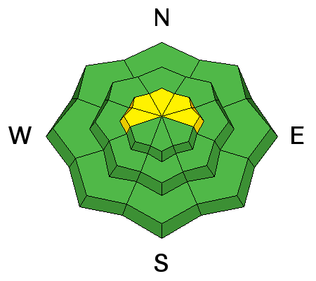
Today you will need to be on the lookout for recently deposited wind slabs on the lee sides of ridge crests and terrain features in upper elevation, wind exposed terrain. Mostly shallow, they shouldn't pose much of a problem, especially for a snowmobiler., But look for signs of instability such as cracking in the snow surface, and characteristic smooth rounded pillows of freshly drifted snow. |
 |
weather The storm is working its way northeasterly and cold air has spilled into the region. Lingering moisture may bring us a couple more inches of snow, mainly before noon. The northern branch of a splitting trough will clip through our region on Tuesday, followed by a weak ridge building for the remainder of the week. By late next weekend, southwest flow sets up again with another series of short wave troughs moving in off the west coast. Today Snow showers, mainly before 1pm. Patchy fog before 11am. High near 28. South southwest wind 10 to 15 mph. Chance of precipitation is 90%. Total daytime snow accumulation of 1 to 2 inches possible. Tonight Partly cloudy, with a low around 18. Southwest wind 5 to 10 mph becoming northeast after midnight. Tuesday A 10 percent chance of snow showers after 11am. Mostly sunny, with a high near 31. Blustery, with a north wind 15 to 20 mph. Tuesday Night Partly cloudy, with a low around 21. Blustery, with a north wind 15 to 20 mph. Wednesday Mostly sunny, with a high near 34. North northwest wind around 15 mph, with gusts as high as 25 mph. |
| general announcements Let me know what you are seeing down there by posting an observation here. You can also call me on my cell phone at 801-647-8896 To receive this advisory by email go here. This information does not apply to developed ski areas or highways where avalanche control is normally done. This advisory is from the U.S.D.A. Forest Service, which is solely responsible for its content. This advisory describes general avalanche conditions and local variations always exist. |
Advisory Hotline: (888) 999-4019 | Contact Information