| Please join us at the 23rd annual Black Diamond Fall Fundraiser Party Thursday Sept 15. Tickets are on sale now here, at the Black Diamond store & at REI. Special bonus raffle for online ticket purchasers! |
| Please join us at the 23rd annual Black Diamond Fall Fundraiser Party Thursday Sept 15. Tickets are on sale now here, at the Black Diamond store & at REI. Special bonus raffle for online ticket purchasers! |
| Advisory: Abajo Area Mountains | Issued by Eric Trenbeath for Sunday - March 6, 2016 - 7:39am |
|---|

|
bottom line The avalanche danger remains generally LOW in the Abajos today. If we get a couple inches of snow by this afternoon, we may some very shallow, isolated wind slabs forming in wind exposed terrain.
|
 |
special announcement
|
 |
current conditions We are on the fringe of a Pacific storm system moving through our area that looks like it may give us a few inches of new snow on top of our tired old surface. Winds are surprisingly light on Abajo Peak this morning averaging 10-15 mph from the southwest. Expect them to increase into the 20-30 mph range later in the day with gusts as high as 50 mph. Winds, temperature and humidity on Abajo Peak. Snow totals at Buckboard Flat. Snow totals at Camp Jackson.
|
 |
recent activity
|
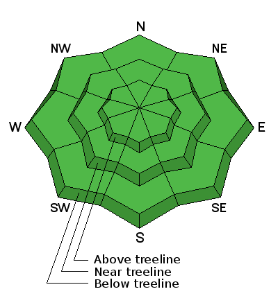
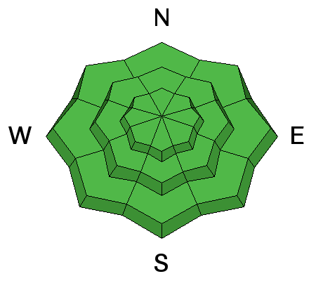
| type | aspect/elevation | characteristics |
|---|

|
|
LIKELIHOOD
 LIKELY
UNLIKELY
SIZE
 LARGE
SMALL
TREND
 INCREASING DANGER
SAME
DECREASING DANGER
|
|
description
I don't see today's forecasted snow totals to have much of an effect on the avalanche danger. If we pick up a couple inches of snow by the end of the day, we may some developing, isolated, shallow wind slabs in upper elevation, wind exposed terrain, but I don't see them posing much of a problem. |
 |
weather A Pacific storm system on a southwest flow is moving through our area though it unfortunately appears to be largely missing the Abajo Mountains. Today will be blustery with light snowfall. Today Snow showers. Some thunder is also possible. High near 38. Windy, with a southwest wind 25 to 35 mph, with gusts as high as 50 mph. Chance of precipitation is 90%. Total daytime snow accumulation of 1 to 3 inches possible. Tonight Snow showers. Some thunder is also possible. Low around 20. Windy, with a south southwest wind 25 to 30 mph decreasing to 15 to 20 mph after midnight. Winds could gust as high as 45 mph. Chance of precipitation is 90%. New snow accumulation of 2 to 4 inches possible. Monday Snow showers likely, mainly before 8am. Cloudy, then gradually becoming mostly sunny, with a high near 30. Blustery, with a west wind 15 to 25 mph decreasing to 5 to 15 mph in the afternoon. Winds could gust as high as 40 mph. Chance of precipitation is 70%. New snow accumulation of less than one inch possible. Monday Night Partly cloudy, with a low around 21. West northwest wind 10 to 15 mph becoming northeast in the evening. Tuesday Mostly sunny, with a high near 32. Breezy, with a north northeast wind 15 to 20 mph. |
| general announcements Let me know what you are seeing down there by posting an observation here. You can also call me on my cell phone at 801-647-8896 To receive this advisory by email go here. This information does not apply to developed ski areas or highways where avalanche control is normally done. This advisory is from the U.S.D.A. Forest Service, which is solely responsible for its content. This advisory describes general avalanche conditions and local variations always exist. |


