| Please join us at the 23rd annual Black Diamond Fall Fundraiser Party Thursday Sept 15. Tickets are on sale now here, at the Black Diamond store & at REI. Special bonus raffle for online ticket purchasers! |
| Please join us at the 23rd annual Black Diamond Fall Fundraiser Party Thursday Sept 15. Tickets are on sale now here, at the Black Diamond store & at REI. Special bonus raffle for online ticket purchasers! |
| Advisory: Abajo Area Mountains | Issued by Bruce Tremper for Sunday - January 31, 2016 - 7:07am |
|---|

|
bottom line Although the avalanche danger is mostly LOW to MODERATE today, it should rise to CONSIDERABLE overnight and perhaps even to HIGH on Monday with the expected snow. The avalanche danger will depend on the amount of snow and wind we get, so you should monitor the snow amounts on the automated weather stations and on this advisory, which I will update again tomorrow morning. You should regularly test how well the new snow is bonded to the underlying snow by digging down with your hand and regularly jumping on small test slopes to see how they respond.
|
 |
avalanche watch I will continue to avalanche watch today, likely turning to an avalanche warning overnight or on Monday with expected snowfall. |
 |
special announcement This advisory provides updated detailed snow and avalanche conditions on weekends. This information is to be used as a baseline for the upcoming week, and users need to be aware of the changing nature of avalanche conditions. New snow, winds, and a rapid rise in temperature all translate to a rise in avalanche danger. Use the links below to stay abreast of current conditions. |
 |
current conditions Hello, this is Bruce Tremper, filling in for Eric Trenbeath while he's away for the next week. I visited the Abajo Mountains on Friday with Dustin Randall and his wife Natalie and we found about 6 inches of soft, settled snow and recrystallized snow on the shady slopes with plenty of breakable sun crusts on all the sunny aspects. It's cloudy and very warm this morning with temperatures near freezing in the mountains. Here's a video I did of the snowpack conditions we found on Friday.
Winds, temperature and humidity on Abajo Peak. Snow totals at Buckboard Flat. Snow totals at Camp Jackson.
|
 |
recent activity
|
| type | aspect/elevation | characteristics |
|---|

|
|
LIKELIHOOD
 LIKELY
UNLIKELY
SIZE
 LARGE
SMALL
TREND
 INCREASING DANGER
SAME
DECREASING DANGER
|
|
description
The avalanche danger today will depend mostly on the amount of snow and wind we get with the second part of this storm. So monitor the snow accumulation at the automated weather stations carefully before you head out (using the links in the Current Conditions section). If we don't get much snow, then conditions won't change much but with significant loading of new, or wind blown snow, then the avalanche conditions could rise rapidly. Be sure to regularly dig down and test how well the new snow is bonding to the old snow surface and jump on small test slopes to see how they respond. I would expect that the snow will slide easiest on the upper elevation, shady aspects where faceted snow has grown near the preexisting snow surface. These faceted layers may produce avalanches several days after the storm. |
 |
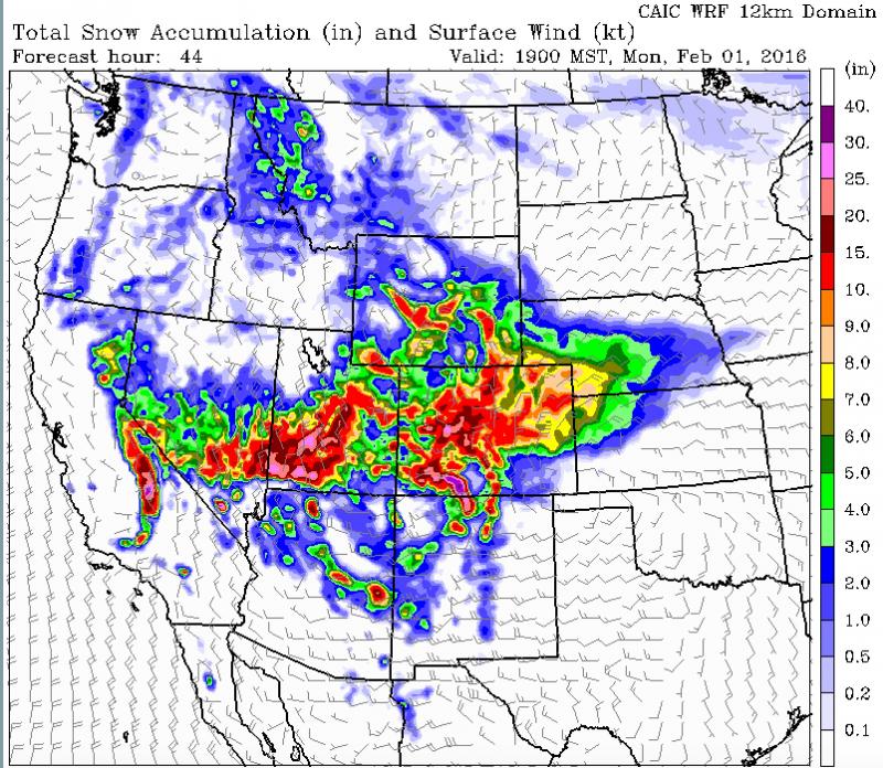
weather The storm is coming in two parts, the cold front that came through last night and the lingering snow showers today, and second, a closed low pressure that will track over the top and to the south of us tonight into Monday. The second part of the storm should be by far the snowiest for southern Utah. The forecast is for about a foot of snow--perhaps more tonight and Monday. Here's the National Weather Service link to the point forecast for the Abajo Mountains. Here's the total, forecast accumulation of snow by Monday the end of the day on Monday.
|
| general announcements Thanks for sending in your observations. You can view Moab observations here. To post an observation go here. To receive this advisory by email go here. This information does not apply to developed ski areas or highways where avalanche control is normally done. This advisory is from the U.S.D.A. Forest Service, which is solely responsible for its content. This advisory describes general avalanche conditions and local variations always exist. |