| Please join us at the 23rd annual Black Diamond Fall Fundraiser Party Thursday Sept 15. Tickets are on sale now here, at the Black Diamond store & at REI. Special bonus raffle for online ticket purchasers! |
| Please join us at the 23rd annual Black Diamond Fall Fundraiser Party Thursday Sept 15. Tickets are on sale now here, at the Black Diamond store & at REI. Special bonus raffle for online ticket purchasers! |
| Advisory: Abajo Area Mountains | Issued by Eric Trenbeath for Monday - November 23, 2015 - 6:44am |
|---|

|
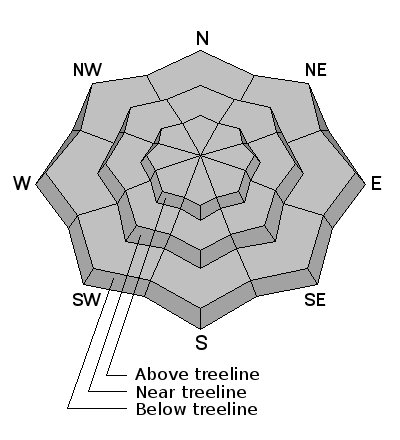
bottom line Weak layers of faceted, sugary snow exist in the snowpack providing an unstable base for future snow to land on. These layers can remain for some time and are called persistent weak layers An isolated danger exists for triggering an avalanche on of these buried weak layers, primarily on mid to upper elevation slopes steeper than 35 degrees that face the north half of the compass. this danger will increase with the addition of more snow.
|
 |
special announcement The Utah Avalanche Center Moab has begun issuing weekend advisories for the Abajo / Blue Mountains. General information will be provided during the week. |
 |
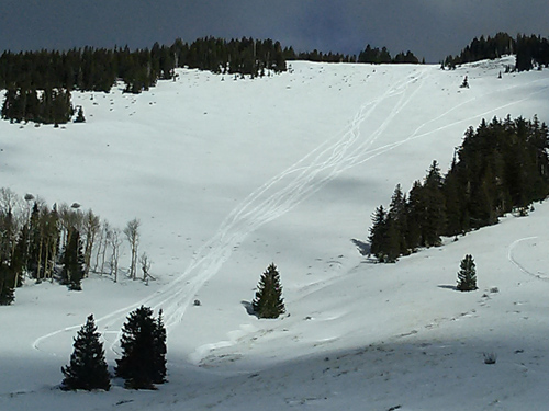
current conditions Low snow, early season conditions prevail in the Abajo / Blue Mountains though we are off to a good start. Snow cover in the range varies from about 12" at the Dalton Springs Trailhead to 30" in sheltered areas near Cooley Pass. Wind and sun exposed terrain has less coverage, and there is a lot of grass poking through as well as bare ground exposed. Winds, temperature and humidity on Abajo Peak. Snow totals at Buckboard Flat.
|
| type | aspect/elevation | characteristics |
|---|

|
|
LIKELIHOOD
 LIKELY
UNLIKELY
SIZE
 LARGE
SMALL
TREND
 INCREASING DANGER
SAME
DECREASING DANGER
|
|
description
|
 |
weather A flat ridge will move over the forecast area today with continued dry, sunny and seasonable temperatures. By Tuesday, a southwest flow sets up over the region ushering in a weak Pacific storm system that will affect our area on Wed into Thu. This storm appears to be lacking in moisture and snow amounts look minimal. Today Sunny, with a high near 45. Calm wind becoming south southwest around 5 mph. Tonight Mostly clear, with a low around 26. Calm wind becoming south around 5 mph after midnight. Tuesday Mostly sunny, with a high near 45. South wind 5 to 10 mph. Tuesday Night Mostly cloudy, with a low around 29. South wind around 15 mph, with gusts as high as 25 mph. Wednesday Partly sunny, with a high near 44. Windy, with a south wind 20 to 30 mph, with gusts as high as 40 mph. Wednesday Night A 20 percent chance of snow. Mostly cloudy, with a low around 21. Thanksgiving Day A 20 percent chance of snow. Partly sunny, with a high near 36. Thursday Night A slight chance of snow before 11pm. Partly cloudy, with a low around 19. Friday A slight chance of snow after 11am. Mostly sunny, with a high near 32. |
| general announcements This information does not apply to developed ski areas or highways where avalanche control is normally done. This advisory is from the U.S.D.A. Forest Service, which is solely responsible for its content. This advisory describes general avalanche conditions and local variations always exist. |