Observation: Session Mountains

Observation Date
1/15/2026
Observer Name
Kelly, Kelly, Pressman, Ernst
Region
Salt Lake » Session Mountains
Location Name or Route
Sessions
Weather
Sky
Clear
Wind Speed
Calm
Weather Comments
Clear skies above heavy valley inversion with calm winds.
Snow Characteristics
Snow Surface Conditions
Faceted Loose
Wind Crust
Melt-Freeze Crust
Snow Characteristics Comments

Snow surface was a mixed bag. Snow depths ranged from 1'-3' depending on aspect and elevation. Areas above 8,000' facing east and north were holding more snow, while southerly and westerly slopes were thin to bare. The snow line was right around 7,000' in protected northerly facing places on the road where it had been packed down.

Photo showing valley inversion and snow coverage in the foreground ( 8,300')

Photo showing thin coverage (8,400')

Avalanche Problem #1
Problem
Persistent Weak Layer
Problem #1 Comments

While we did find faceted snow on north-east facing slopes it is not currently a problem. This is a layer that I'll be paying attention to when we start to add more snow in the future. With an extended period of high pressure, this layer will continue to become weaker before the next storm.

Snow Profile
Aspect
Northeast
Elevation
8,500'
Comments

Snowpit @ 8,500' showed a mix of facets and crusts. We were able to stay above the facets on the ground because of how stout the Christmas Rain Crust was. There were slopes with near surface faceting (north-east) and slopes that were frozen at the start of the ride and then melting on the way out (south-west).

Overall we found a very low snowpack with a very low avalanche danger. Biggest hazard was hitting barely covered stumps, logs, rocks, and fences. Nearby Snotel Station (Parrish Creek) at 7,760' shows a total depth of 22" which is about 59% of normal. In 2023 around this time period this station was reporting 78" of snow.

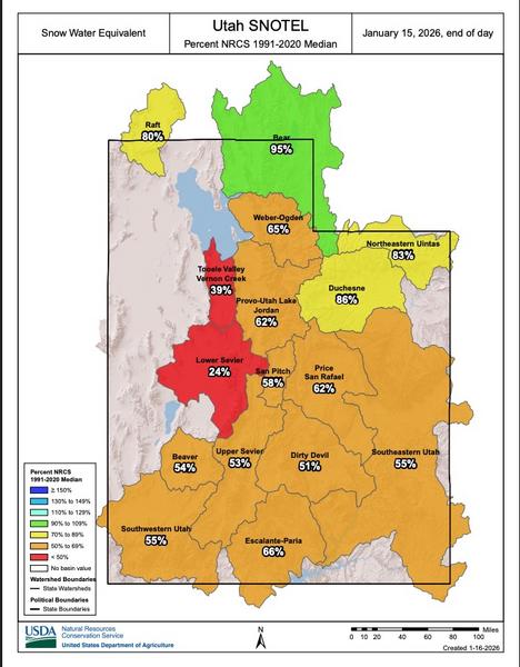
Current snow water equivalent for the state of Utah as of 1/15/2026

Today's Observed Danger Rating
Low
Coordinates