If you have been following along this winter, you know by now that poor snowpack structure is widespread. Reports of cracking and collapsing have been isolated at best. I did not experience any of these red flags on my tour today, and I made a point to travel in untouched snow as much as possible. Two extended column tests today produced no results (ECTX). My trip up to the avalanche site on the East Face of Laurel on Saturday provided some good insight as to why we are not getting much feedback from the snow right now. Most places we are able to safely travel are much different than the big, steep alpine bowls above treeline. The terrain we are able to safely access has poor structure, but the overlying slab doesn't seem to have enough body to communicate a failure below the Christmas rain crust. So far, the rain crust seems to be "bridging" the weight of skiers and riders on most slopes near treeline and below.
The alpine is a different story. Relentless winds during the December dry spell have built thick, hard slabs across leeward alpine terrain. The Christmas rain crust has made these slopes well connected, resulting in the wide propagation we saw in the Dark Canyon avalanche. This setup is typically hard to trigger, but the right combination (like a triggered wind drift, or the weight of a snowmobile) and perhaps a thinner slab margin can result in a large, destructive avalanche.
The snowpit below is from my tour today (Monday), and test results were ECTX x2.
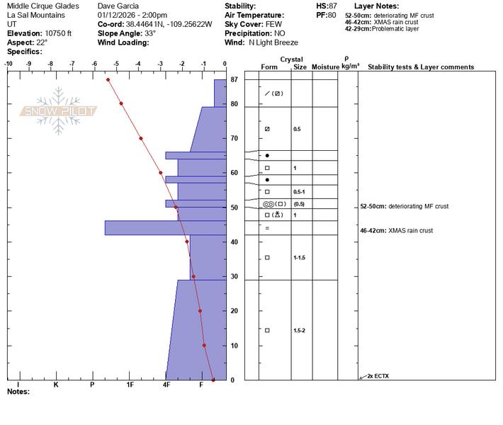
It is worth comparing this pit to the one I dug on the right flank of the Dark Canyon avalanche. It is rare that we are able to access big steep slopes in the alpine this time of year, and this snow pit is valuable information that can help explain why big avalanches are possible in alpine terrain, while most other terrain is not providing much feedback to our backcountry observers.
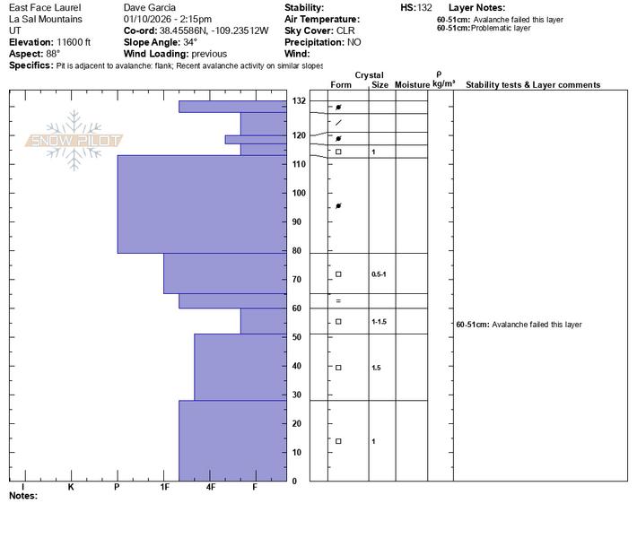
I think the overlying slab is the key to instability. A quick look at both pits reveals a much different structure above the Christmas rain crust. I am being very careful with my terrain choices right now. I am avoiding steep slopes above treeline. Near treeline and below, I am avoiding steep convexities, terrain traps, and shallow, rocky zones. The bottom line is that the weak layer is stubborn to trigger, and human-triggered avalanches are possible, but not likely. However, the sheer size and destructive power make for considerable danger in big, steep terrain above treeline.


