Observation: Empire Pass

Observation Date
1/10/2026
Observer Name
T. Matthews WPT AIARE Rec 1.
Region
Salt Lake » Park City Ridgeline » Empire Pass
Location Name or Route
Empire Pass Bonanza Flats.
Weather
Sky
Clear
Wind Direction
Northeast
Wind Speed
Light
Weather Comments
Winds in our terrain today were out of the NE in the morning hours. Had loaded small S and SE terrain features into 4F+ slabs one to two feet deep. These slabs likely formed yesterday through last night, and were stubborn to triggers. Temps seemed as forecasted. Low to mid 20's.
Snow Characteristics
New Snow Depth
10"
New Snow Density
Low
Snow Surface Conditions
Powder
Snow Characteristics Comments

Most recent storm snow consisted of 10" of cold smoke low density Utah gold. Steep south in the mid elevation band will likely have a thin crust on it tomorrow morning.

Red Flags
Red Flags
Recent Avalanches
Wind Loading
Poor Snowpack Structure
Red Flags Comments
Observed red flags today. Poor snowpack structure. The winds were transporting snow in a variety of directions off the top of Clayton's today. Recent avalanches reported within the past 48 hours, and I'd suspect we will hear about a handful that were triggered today.
Avalanche Problem #1
Problem
New Snow
Trend
Decreasing Danger
Problem #1 Comments

No signs of instability in the newest storm snow in the areas we traveled today. Mid Elevation band. You had to find fatter and stiffer pockets of wind drifted snow to get any cracking.

Avalanche Problem #2
Problem
Persistent Weak Layer
Trend
Same
Problem #2 Comments

The PWL is becoming more stubborn, and displays no signs of instability. No cracking or collapsing in our mid elevation band travels today. Could not get CT's to initiate failure, nor get propagation in the PWL's while performing ECT's. Same test results from 2 other groups in the same zone.

Comments

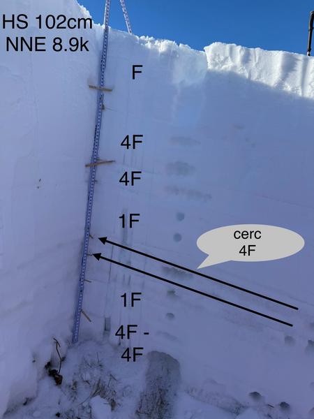
Photo 1. Snowpack Structure.

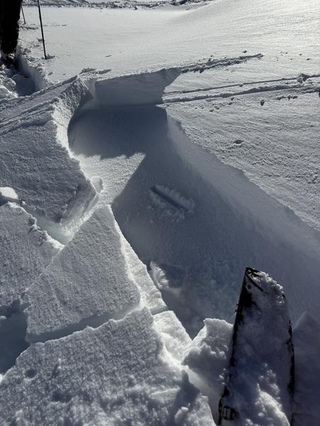
Photo 2. Cracking in stubborn wind slabs.

Photo 3. 1' 4F+ wind slab running a few feet on a 31 degree slope.

Today's Observed Danger Rating
Moderate
Tomorrows Estimated Danger Rating
Moderate
Coordinates