Observation: Park City Ridgeline

Observation Date
1/10/2026
Observer Name
Paradis
Region
Salt Lake » Park City Ridgeline
Location Name or Route
Upper Mill Creek
Weather
Sky
Clear
Wind Speed
Calm
Weather Comments
About 15 degrees this morning but warmed up quite a due to high pressure and sinking air. No wind where we were but you could see some snow transport along Cardiff ridgeline
Snow Characteristics
New Snow Depth
6"
New Snow Density
Low
Snow Surface Conditions
Powder
Snow Characteristics Comments

All aspects held good snow as of this morning. We skied south facing today because it probably won't be good for very long due to warming aloft and is the primary purpose of this observation.

It started to warm a bit on south facing slopes later and it's possible they will have a crust tomorrow, particularly below about 9000 feet. We had a little sticking on our skins. At 9000 feet or below there seems to be much less snow than above. Above 9000 feet coverage was surprisingly good on south facing. This must have been where the rain-snow line was for one of our recent warm storms.

In one thin location on a south facing slope snow felt weak, thin and almost like isothermic snow like you might encounter in the spring. It seems like the thin, low density snow doesn't hold up well to heat.

Red Flags
Red Flags
Heavy Snowfall
Poor Snowpack Structure
Red Flags Comments
Overall snow pack is still thin and we just received a bunch of new snow. Those are two simple red flags for me.
Avalanche Problem #1
Problem
New Snow
Trend
Decreasing Danger
Problem #1 Comments

On north facing, below the most recent ~6" of new snow there appeared to be either a density change or a weak layer (like surface hoar noted in other observations). The storm prior to this most recent one seemed reasonably well attached to the rain crust in hand pits (I did not do any formal tests).

Note: below the rain crust, other observations have noted some weaker snow. I didn't dig that far down and was mostly on south facing today so didn't include it in this observation.

Avalanche Problem #2
Problem
Wet Snow
Trend
Decreasing Danger
Problem #2 Comments

On south facing, I'm not sure if it will get warm enough to have wet snow issues but we have received a lot of new snow that is sensitive to heat. This may not be an issue but as noted above, there were spots were it was getting warm and mushy. Tomorrow is supposed to be warmer.

Comments

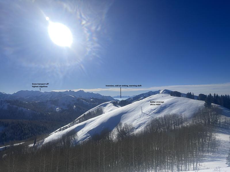
The picture below told me a lot about the weather and snow. Unfortunately it seems like it will stick around for a while.

Today's Observed Danger Rating
Moderate
Tomorrows Estimated Danger Rating
Moderate
Coordinates