
Join us for the 33rd Backcountry Benefit - Get Your Tickets Now!

Observation: 10420

Observation Date
12/27/2025
Observer Name
Gagne / Shade
Region
Salt Lake » Big Cottonwood Canyon » 10420
Location Name or Route
10,420' to PC Ridgeline
Weather
Sky
Overcast
Precipitation
Moderate Snowfall
Wind Direction
West
Wind Speed
Moderate
Weather Comments
Moderate winds from the west blowing and drifting snow along upper-elevation ridgelines. Snowfall diminished around 0900, with even some peaks of sun by late morning.
Snow Characteristics
New Snow Depth
8"
New Snow Density
Medium
Snow Surface Conditions
Powder
Snow Characteristics Comments

Storm snow depths since 12/26 are 15-20 cms (6-8 inches). Some small, sensitive, shallow wind drifts on ridge lines.

Red Flags
Red Flags
Heavy Snowfall
Wind Loading
Poor Snowpack Structure
Red Flags Comments
PWL at the base of the snowpack remains reactive with full propagation where the Christmas Eve Rain Crust (CERC) is thinner (2-3 mm).
Avalanche Problem #1
Problem
New Snow
Trend
Decreasing Danger
Problem #1 Comments

The storm snow is mostly right-side up, with a few density inversions during periods of heavy precipitation which should settle out quickly. Some wind drifting with shallow soft slabs and small cornices along the ridgelines. We noted two small natural avalanches from a cornice fall.

Once the Christmas Eve Rain Crust was buried, new snow came in as dense graupel with warmer temperatures and was well-bonded to the rain crust, but the graupel could still act as a weak layer in areas with a denser slab on top, especially on slopes where the graupel has pooled and created a deeper layer.

Avalanche Problem #2
Problem
Persistent Weak Layer
Trend
Same
Problem #2 Comments

The only pit we got full propagation was at 9,600' on a N aspect near Lane's Leap. ECTP21 down 70 cms, failing in dry facets and depth hoar. The Christmas Rain Crust was 2 mm in this location. All other pits were poor quality ECTN failing in the graupel layer above the Christmas Rain Crust.

Comments

We dug several pits on northerly aspects, and found a small disparity in the thickness of the Christmas Rain Crust:

(1) 9,560' NE aspect 2-3 mm crust

(2) 9,600' N aspect 2 mm crust

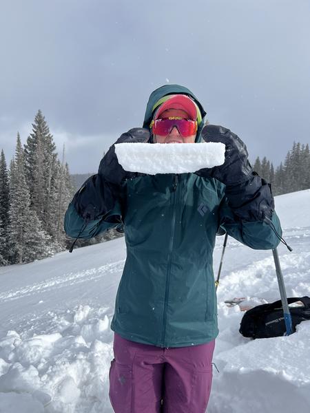
(3) 9,830' N aspect 3 cm crust (photo below showing Jess Shade with the thick crust)

(4) 10,400' N aspect 1-2 mm crust

We also found mostly dry facets and depth hoar down near the ground. In areas where the crust is thinner, it is possible a wind drifted slope could create enough of a load to affect the deeper PWL.

The Christmas Rain Crust is strong and supportable and provides a nice base for travel and turns in the new snow. Fortunately, we were not finding a dust-on-crust situation as the snow from Friday and Saturday came in dense and bonded to this crust.
Today's Observed Danger Rating
Moderate
Tomorrows Estimated Danger Rating
Moderate
Coordinates



