Observation: Little Cottonwood Canyon

Observation Date
3/2/2024
Observer Name
Kelly
Region
Salt Lake » Little Cottonwood Canyon
Location Name or Route
Upper Little Cottonwood Canyon
Weather
Sky
Obscured
Precipitation
Heavy Snowfall
Wind Direction
Northwest
Wind Speed
Strong
Weather Comments
I went out for a tour after the frontal passage around 430pm. At that point the thunder, lightning, and very strong winds had slowed down. The temperature had dropped and it was snowing hard 2"-4" an hour. The storm started with very strong winds and as the winds picked up I observed graupel up to 6mm in size that fell with a dust tint.
Snow Characteristics
New Snow Depth
9"
New Snow Density
Medium
Snow Surface Conditions
Powder
Snow Characteristics Comments
Good skiing on north and east aspects. West and south aspects still had a melt freeze crust that you could feel on steeper terrain.
Red Flags
Red Flags
Heavy Snowfall
Wind Loading
Avalanche Problem #1
Problem
New Snow
Trend
Same
Problem #1 Comments
Density changes within the storm snow and I was able to trigger an avalanche 6" deep running on the old/new storm interface associated with the dirt layer. The first photo below is a north facing slope at 9120'. This avalanche was intentionally triggered and was 45'-50' wide and and ran 100' piling up into the gully. It was a soft slab avalanche and broke at my skis. I also observed an avalanche (second photo) on a northeast facing slope at 9600' that ran within the new snow and had been covered back over by more new snow. This is similar to what you may have seen in other steep terrain during periods of increased snowfall rates.

Avalanche Problem #2
Problem
Wind Drifted Snow
Trend
Same
Problem #2 Comments
With forecasted strong winds there may be areas of wind-drifted snow that will be sensitive to the additional weight of a backcountry traveler.
Snow Profile
Aspect
East
Elevation
9,600'
Slope Angle
35°
Comments
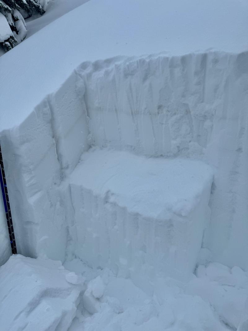
I dug a pit to see how the new/old snow interface at the dirt layer was reacting and see if I could find any remnants of the PWL. I dug on a 35° east facing slope at 9640'. The total height of snow was 10' (310cm).
The weakest layer was the new/old snow interface that was reactive with propagation (ECTP 7 and ECTP 10) 9.8"(25cm) from the surface. This is the same layer that I believe was the failure point in the above avalanches. The other result that got my attention was failure with propagation 21.5" (55cm) down from the surface. This layer failed on small grained faceted crystals associated with a decomposing melt-freeze crust (ECTP 27 and ECTP 28). This is the layer that gets my attention for creating much larger avalanches.
Below photo showing pit wall with failure plane at 55cm from the surface and dust layer 25cm from the surface. Everything above the dust layer was new snow and there was an inch of graupel mixed with the dust.
Today's Observed Danger Rating
Considerable
Tomorrows Estimated Danger Rating
None
Coordinates