Observation Date
1/22/2024
Observer Name
Kelly, Pressman
Region
Salt Lake » Big Cottonwood Canyon » Mineral Fork
Location Name or Route
Mineral Fork
Weather
Sky
Few
Wind Speed
Calm
Weather Comments
Calm winds, warm air temperatures.
Snow Characteristics
New Snow Depth
1"
New Snow Density
High
Snow Surface Conditions
Powder
Melt-Freeze Crust
Snow Characteristics Comments
Thin melt-freeze crust on surface up to 7300'. Above 7300'-7800' was a melt freeze crust with an 1" of new snow on the top of the crust. Above 7800' the crust was not present and it was soft new snow travel.
Red Flags
Red Flags
Recent Avalanches
Rapid Warming
Poor Snowpack Structure
Avalanche Problem #1
Problem
Wet Snow
Trend
Same
Problem #1 Comments
Photo of a human triggered wet slab avalanche failing on facets at 6700' northwest facing slope. Isolated to the terrain feature.
Avalanche Problem #2
Problem
Persistent Weak Layer
Trend
Same
Problem #2 Comments
Photo of a natural avalanche on an east facing slope at 6800'. This looks to have failed during the storm as there was fresh snow on the debris in the creek. Approximately 1' deep x 70 wide and ran 100' vertical into the creek.
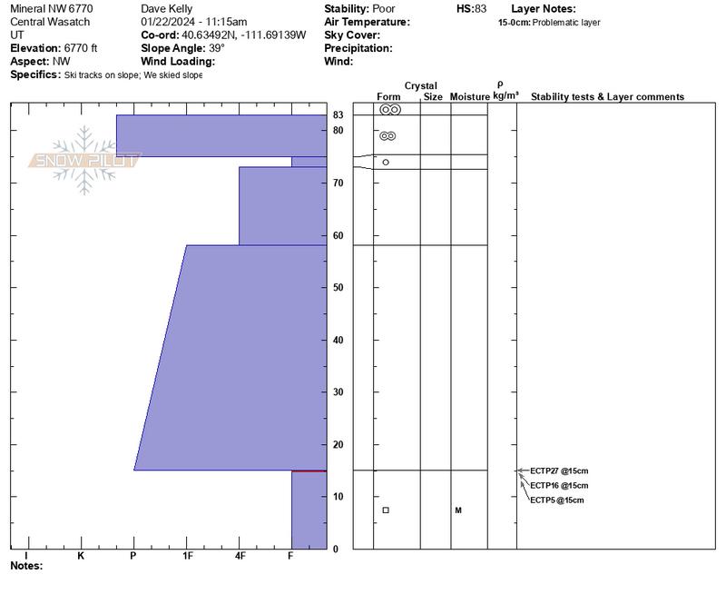
Snow Profile
Aspect
Northwest
Elevation
6,700'
Slope Angle
39°
Comments
Total HS was 3' (83cm) and as I went back into thinner (more shallow) and steeper portions of the slope it became easier to trigger an extended column test with propagation. All of these failures were on facets 6" off the ground.
1st ECT-ECTP27@15cm
2nd ECT- ECTP16@15cm
3rd ECT-ECTP5@15cm
We also went to look at the Avalanche in
GB No that was first reported to the UAC on January 19th as part of this
REPORT .
Today's Observed Danger Rating
Moderate
Tomorrows Estimated Danger Rating
Moderate
Coordinates