
Holiday Auction is Live!

Observation: Whitney Basin

Observation Date
11/20/2026
Observer Name
VandenBos
Region
Uintas » Whitney Basin
Location Name or Route
Whitney to Moffitt
Weather
Sky
Overcast
Precipitation
Moderate Snowfall
Wind Direction
West
Wind Speed
Light
Weather Comments
Light to moderate snowfall throughout most of the day. One minute the skies would lighten and try to clear, and the next it would be snowing big, cold, fat flakes. This added another 3" of fluff on top of the week's storm snow during the day. On the drive back towards Kamas at day's end, skies cleared a bit for sunset, the moon came out...and then it hammered snow most of the drive! Winds had eased significantly in the afternoon, though there were a few brief blustery periods.
Snow Characteristics
New Snow Depth
18"
New Snow Density
Low
Snow Surface Conditions
Powder
Snow Characteristics Comments

18" of new snow since the storm trail got rolling on Tuesday. This fell in a few pulses. Interfaces between storm waves are present. I did not travel through snow where this looked like it would be an issue, but without a slab in most places its hard to be confident on that.

Red Flags
Red Flags
Recent Avalanches
Wind Loading
Cracking
Collapsing
Poor Snowpack Structure
Red Flags Comments
Plenty of red flags today. Muffled collapses in sheltered terrain, booming collapses where the wind had added load and stiffened the snow. I observed one avalanche that failed on the Lucky Friday facets. I'll submit a brief, separate avalanche observation for this.
Avalanche Problem #1
Problem
Persistent Weak Layer
Problem #1 Comments

Well-developed facets beneath this week's storm snow are my primary concern. In sheltered terrain, these facets are buried 1.5 feet down in the Whitney area. The slab of new snow is quite soft in sheltered terrain, but I did experience a handful of collapses with this snowpack setup. This problem is at its worst where consistent S-SW winds through the storms have added significant load and structure. Photo below shows snowpack at 10,100' on northeast aspect.

Avalanche Problem #2
Problem
New Snow
Problem #2 Comments

While the PWL is far and away my primary concern, you could run into a few issues within the new snow. Along ridgelines in terrain lee to the wind, soft wind slabs have formed in many places. In most places, these are resting on top of the PWL problem, and any slides would likely involve these facets. Small sluffs within the low-density new snow would be easy to trigger, and tomorrow's sun may bring on a round of loose snow activity if the clouds peel back.

Comments

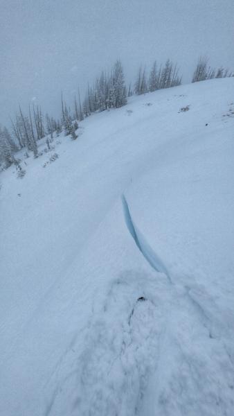
Snowpacks don't love rapid change, and facets don't love a slab on top of them. Things escalted quickly in the Uintas this week. In many places we've got a lot of fresh, soft snow on rocks and dirt. But where the new snow fell on the early November facets, things are touchy. I saw one recent avalanche that failed on this layer, had a handful of muffled collapses in sheltered terrain, and had some booming collapses where the wind had added extra load on top. I have little doubt that remotely triggering avalanches from ridgelines was in the cards today. The photo below shows a deep crack that opened as I stomped along the low angle ridge above. This slope has a pretty stubborn angle and the snow shifted but did not avalanche. Cracks extended in both directions, across roughly 200 feet of terrain.

Coordinates


