Right now, we need both wind-stiffened snow, and older, weak snow in order to have an issue. In sheltered terrain, Tuesday's storm did not do much to change the avalanche picture. In terrain where the wind built slabs, its a different story. I had a few localized collapses today in this type of terrain.
There are two prominent PWLs in the Uinta snowpack. Their distribution is similar; cold, shady, upper elevation slopes
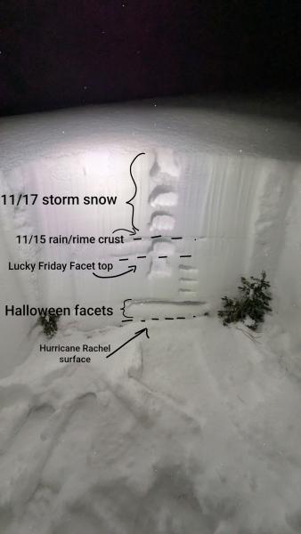
- At the base of the snow that fell around Halloween, we have a layer of facets sitting above the stout (but faceting and degrading) Hurricane Rachel surface. This layer is near the base of the snowpack, about 1.5 to 2 feet down. I've been calling these the "Halloween Facets" in by brain.
- We started to bury the weak snow that was generated during the early/mid November drought on Friday the 13th. This layer is now down about a foot in the Uintas. I've been calling these the "Lucky Friday Facets" in my brain.
As you can see in the image below, the snowpack in sheltered terrain has lost a ton of strength thanks to the early/mid November drought. No shortage of weak snow out there, but the slab portion of the equation is currently only found in windy terrain. This may be changing with additional loading this week.