Holiday Auction is Live!

Observation: Wolverine Peak

Observation Date
11/18/2026
Observer Name
J. Miller, Kelly
Region
Salt Lake » Big Cottonwood Canyon » Wolverine Peak
Location Name or Route
Grizzly to Wolverine to Catherines Pass
Weather
Sky
Few
Wind Direction
Southwest
Wind Speed
Moderate
Weather Comments
The day started out with clear skies and light to moderate wind. Wind picked up around 12:30 and began blowing moderate gusting to strong. About the time the winds picked up the cloud cover increased and we observed high thin clouds. We could see wind transporting snow on the highest ridgelines above 10,000'. We observed riming on trees above 10,300'.
Snow Characteristics
New Snow Depth
16"
New Snow Density
Low
Snow Surface Conditions
Powder
Snow Characteristics Comments
New snow was soft and unconsolidated on north-east facing terrain. As we travelled around the compass southerly and westerly facing slopes started to soften as they took on heat throughout the day; we observed a thin melt freeze layer on the surface.
Red Flags
Red Flags
Recent Avalanches
Poor Snowpack Structure
Red Flags Comments
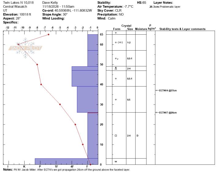
In our travels today we noticed a few avalanches around the north end of the compass that likely failed during the storm overnight. We dug two pits that showed facets a layer of facets 8"-12" thick ( 20-30cm) near the ground.
Avalanche Problem #1
Problem
New Snow
Problem #1 Comments
New snow lacked cohesion on north facing slopes that did not see the sun's heat. On south facing slopes the new snow has started to settle and become more cohesive.
Avalanche Problem #2
Problem
Persistent Weak Layer
Snow Profile
Aspect
East
Elevation
10,500'
Slope Angle
30°
Comments

Failure in above snowpit ( East Tuscarora) was on a graupel interface.

Below snow pit, crystal card marks failure at new/old snow interface which failed on dry faceted snow below the newest snow.


Below photos showing natural avalanche activity that likely occurred overnight during peak snowfall rates.

Photo below showing drifting snow on the Ridgetops. Nearby Brighton Great Western Weather Station recorded winds blowing from the south in the 20's gusting to the 30's MPH.


Today we travelled on ridgelines and skied lower angle high elevation north facing slopes. We talked to a couple groups that skied steeper facing north aspects above 10,000' and reported cracking and collapsing likely failing on the new/old snow interface above the dry faceted layer. There was some fun turns to be had in upper elevation north facing terrain but low snow danger is still at an all time high.


Coordinates
Snow Pilot URL