
Holiday Auction is Live!

Observation: Lone Pine

Observation Date
11/17/2026
Observer Name
Garcia/Lurie
Region
Moab » Gold Basin » Lone Pine
Location Name or Route
Gold Basin to Lone Pine
Weather
Sky
Obscured
Precipitation
Light Snowfall
Wind Direction
South
Wind Speed
Strong
Weather Comments
The sky was obscured all day, and visibility was limited. Ridge-top winds were blowing from the south in the strong range with extreme gusts. Winds down in Gold Basin were swirling, but primarily blew from the west, cross-loading the north-facing terrain we were skiing in. Snowfall was light at the start of our tour. S2 snowfall started around 2 PM.
Snow Characteristics
New Snow Depth
4"
New Snow Density
Medium
Snow Surface Conditions
Powder
Dense Loose
Snow Characteristics Comments

The 10 inches of new snow from Saturday's storm have settled to about 8 inches. It snowed another 4 inches at 0.4 SWE as of 5 PM Tuesday. As we dropped elevation back to the TH, the snow falling was wet. The rain-snow line was around 8,000 feet.

Red Flags
Red Flags
Wind Loading
Red Flags Comments
Strong to extreme winds were blowing and drifting the snow from Saturday's storm. Snowfall today was depositing on the leeward sides of ridges and terrain features. Whole trees were in motion, and at the end of our tour, we watched a mature conifer blow over from a very strong gust.
Avalanche Problem #1
Problem
Wind Drifted Snow
Trend
Increasing Danger
Problem #1 Comments

Lots of blowing and drifting snow today. We spent our day skiing Lone Pine and observed the upper starting zone being actively loaded by drifting snow all day. We ran into thin wind slabs around 10,900'. We topped out around 11,000'. If we ascended any higher, the wind slab would have become thicker and possible to trigger. This will be your primary concern on Wednesday. Look for widespread areas of wind-drifted snow near treeline and above, especially on slopes facing W-N-E. NWS is forecasting gusts up to 45 MPH on Tuesday night.

Snow Profile
Aspect
North
Elevation
10,600'
Slope Angle
30°
Comments

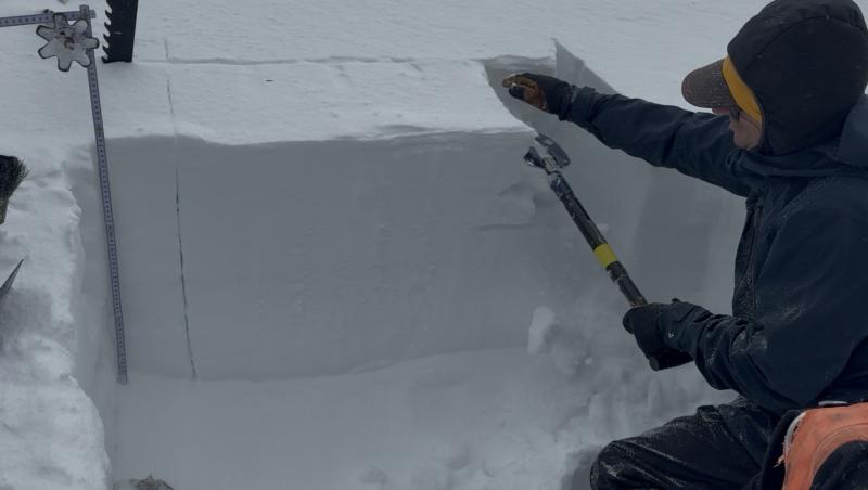
We dug down to the October 20 rain crust; our primary focus today was the facets beneath Saturday’s storm snow. At the base of Lone Pine, the new snow remains less dense than the underlying facets. The profile showed an F over F+ structure.

We performed two Extended Column Tests, and in both cases, the storm snow compressed beneath my shovel without producing a failure. Both tests were ECTX. A quick-and-dirty compression test produced a CT21 down 35 cm, failing on the facets.

Away from the wind zone, Saturday’s storm snow has not yet gained enough cohesion for a failure in the weak layer to propagate and produce an avalanche. However, the story will be different on slopes where recent wind-drifted snow has formed slabs.

Visibility should improve considerably on Wednesday, and I expect to see some wind slab activity near and above treeline.

Today's Observed Danger Rating
Moderate
Tomorrows Estimated Danger Rating
None
Coordinates


