Observation: Gold Basin

Observation Date
2/18/2026
Observer Name
Garcia
Region
Moab » Laurel Highway » Goldminer's » Gold Basin
Location Name or Route
Laurel Highway to Gold Basin
Weather
Sky
Obscured
Precipitation
Light Snowfall
Wind Direction
South
Wind Speed
Strong
Weather Comments
The weather forecast held up for the most part. Snowfall began around 10:30, and the heaviest PI rates were right around noon. Winds were strong out of the south all day, with gusts in the extreme range. I observed intense snow transport all day.
Snow Characteristics
New Snow Depth
3"
New Snow Density
Low
Snow Surface Conditions
Powder
Snow Characteristics Comments

It snowed an additional 3 to 4 inches today. This improved riding on northerlies, which were upside down and grabby yesterday. Solar aspects are starting to take shape and offer fun "dust on crust" conditions right now.

Red Flags
Red Flags
Recent Avalanches
Wind Loading
Cracking
Collapsing
Poor Snowpack Structure
Red Flags Comments
I checked a lot of boxes here, but honestly, I was surprised by the lack of feedback I got from the snowpack today. I had one audible collapse. And cracking was isolated. I made a point to travel on as much untouched snow as possible. I avoided wind-loaded terrain for obvious reasons. My take is this; out of the wind zone, the recently buried NSF layer has had time to adjust to incremental loading. Since 2-11, we have received roughly 1.16" of SWE over the course of three storm events. These storms have been spaced out enough that the storm snow on its own is not pushing the weak layer past its breaking point. The recent strong winds are the driving factor behind slab formation and instability right now. Steep, wind-loaded slopes NTL and ATL are the bullseye for avalanches.
Avalanche Problem #1
Problem
Wind Drifted Snow
Trend
Increasing Danger
Problem #1 Comments

Yesterday, I found drifts on leeward slopes up to two feet deep and 1F density. Today, I observed intense snow transport all day, and these drifts are growing in size. I would expect to find slabs of wind-drifted snow up to three feet deep on Thursday. These slabs sit on top of weak, faceted snow and will be sensitive to the weight of a skier or rider. These are the real deal and should be avoided.

Avalanche Problem #2
Problem
Persistent Weak Layer
Trend
Same
Problem #2 Comments

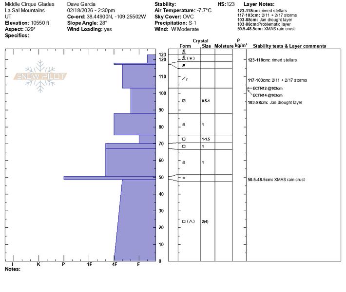
The well-preserved NSF layer is easily seen in this profile, buried beneath recent storm snow. I'll refer to the NSF layer as the "2-11" interface, as it was buried on the night of February 11th. The 2-11 interface seems to have adjusted to recent loading, and I didn't find it to be very reactive in my travels today. You can see the ECT results from this pit. I also dug a pit at a similar aspect and elevation on Julie's backside and got ECTN 13. Very consistent results, but not all that alarming. It will take some amount of wind drifting to get this layer to fail. As you enter the upper reaches of the near treeline zone, you will encounter drifted snow, and this layer will be more reactive. Clear skies are in the forecast for Thursday, and I suspect it will be a good day for viewing recent avalanche activity near treeline and above.

Coordinates