Observation: West Desolation Ridge

Observation Date
2/11/2026
Observer Name
Torrey & Collett
Region
Salt Lake » Big Cottonwood Canyon » Mill D North » West Desolation Ridge
Location Name or Route
West Willow to West Deso
Weather
Sky
Overcast
Precipitation
Light Snowfall
Wind Direction
Southwest
Wind Speed
Light
Weather Comments
The rain-snow line while driving up the canyon this morning was right around 7500 feet. We found 4-6 inches of moist snow and graupel. Precipitation was light in the morning and stopped late morning before increasing again around 4:30 PM. Wind blowing from the SW was light to moderate with some periods of stronger gusts, calling attention to large plumes of snow drifting.
Snow Characteristics
New Snow Depth
5"
New Snow Density
Medium
Snow Surface Conditions
Powder
Melt-Freeze Crust
Damp
Snow Characteristics Comments

Red Flags
Red Flags
Wind Loading
Cracking
Collapsing
Poor Snowpack Structure
Red Flags Comments
Easy to provoke cracking within the recently wind-drifted snow lee of the ridge top. Experienced a few localized collapses in places where a thin crust, below the new snow, caps the weak facets.
Avalanche Problem #1
Problem
Wind Drifted Snow
Trend
Increasing Danger
Problem #1 Comments

Observed easy cracking with fresh wind drifts on north aspects. Some of the drifts were up to 2 feet deep. Instabilities were confined to the immediate ridge top and tapered down-slope quickly.. These cohesive drifts were sensitive to human-triggering but lacked the volume or connectivity to run more than 10-15 feet.

Comments

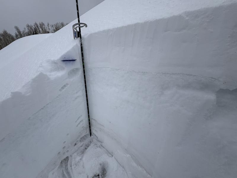
On a 36-degree, east-facing slope at ~9500 feet, I found that the warm temperatures had saturated the upper snowpack and refrozen into a thick, hard crust. I did not find faceted snow here. The weakest interface was between the new snow that fell yesterday and the dense and snow from today.

On a west-facing slope near 9600 feet, we found a very concerning upper snowpack. A thin crust caps a layer of weak faceted snow. Some of the weakest snow we observed during our day.

Photos are of the associated snow pits above. Photo 1: East aspect, Photo 2: West aspect.

East

West

Today's Observed Danger Rating
Moderate
Tomorrows Estimated Danger Rating
None
Coordinates