Observation: Reids Peak

Observation Date
2/9/2026
Observer Name
Climaco
Region
Uintas » Reids Peak
Location Name or Route
Reid’s Peaks
Weather
Sky
Overcast
Precipitation
Light Snowfall
Wind Direction
West
Wind Speed
Strong
Weather Comments
Wind was all over the map today, blowing strong out of the West but also coming upslope from the East in a likely rotor effect.
Snow Characteristics
New Snow Density
Low
Snow Surface Conditions
Dense Loose
Faceted Loose
Wind Crust
Red Flags
Red Flags
Wind Loading
Cracking
Collapsing
Poor Snowpack Structure
Red Flags Comments
It’s all there and getting worse.
Avalanche Problem #1
Problem
Wind Drifted Snow
Trend
Increasing Danger
Problem #1 Comments

Winds were depositing snow in all kinds of weird-ass ways up there today, scouring some surfaces while creating touchy slabs right next door. One minute I wanted my ski crampons, the next some fatter skis. This was a big heads up that it’s going to be a minefield in the alpine as this storm gets going.

Avalanche Problem #2
Problem
Persistent Weak Layer
Trend
Increasing Danger
Problem #2 Comments

Yep, I’m still here, that pile of totally unconsolidated facets that 2026’s been calling a snowpack. I know it looks like I have zero integrity but I’m telling you, you can trust me this time. I promise I can hold those wind slabs.

Comments

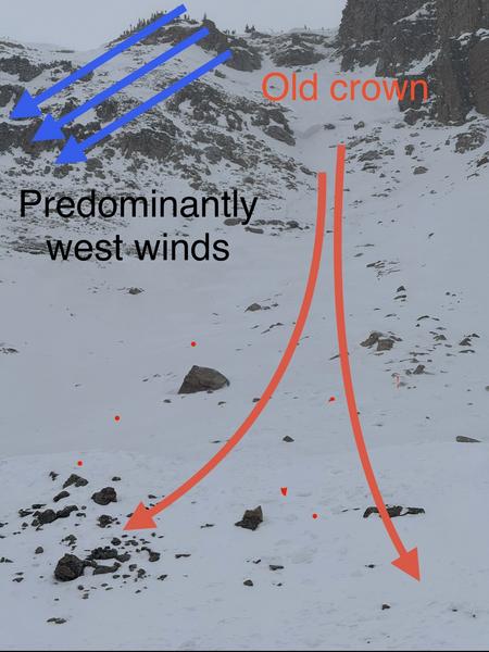
Unpleasant is the word that comes to mind to describe my afternoon in the Bald-Reid cirque. Winds were blowing from seemingly every direction at once, doing all sorts of weird things to the snow surface and making travel a bit nasty.

Old debris still visible from a large avalanche that broke below the Bald-Reid col provided a nice teachable moment. It was a textbook case of a thin snowpack with a wind slab atop a weak layer failing in steep, rocky terrain. It appears this tune is on repeat as the high altitude, wind-exposed terrain is once again loading up.

Today's Observed Danger Rating
Low
Tomorrows Estimated Danger Rating
Moderate
Coordinates