
Nikki Champion
Forecaster
Week in Review: Avalanche Conditions and Snowpack Developments (March 14-March 20, 2025)
Each week, we look back at the key snowfall, weather, and avalanche events from the previous week. For archived forecasts, visit the Salt Lake Mountains’ past updates.

Overall Summary:
This week in the Salt Lake mountains delivered the full March experience—everything from heavy snow and strong winds to clear skies and cold temperatures. Classic Wasatch conditions! The riding has been excellent, with fresh snow in many areas, but avalanche danger remained elevated throughout the week.
Avalanche conditions were CONSIDERABLE at mid and upper elevations most days, driven by consistent winds forming wind-drifted slabs. Persistent weak layers, especially on north-facing terrain, continued to be a concern, and storm snow added extra instability across the board. With 2–4 feet of new snow in many areas and over 8 feet in higher terrain since the start of the month, there was plenty of fresh powder, but cautious route-finding and conservative decision-making were essential.
Both natural and skier-triggered slides were reported, particularly in Little Cottonwood Canyon. As temperatures warmed midweek, wet snow instability developed at lower elevations and on sunny aspects, adding another layer of complexity. Avalanche mitigation efforts were frequent, especially along canyon roads, where natural slides impacted travel. By Thursday, winds had calmed slightly, and light snowfall kept things fresh. It was still a great time to be in the mountains with careful planning.
Friday, March 14
A stormy day in the Salt Lake mountains, with strong west/northwest winds gusting into the 50s at upper elevations and wind chills dropping below zero. Snowfall continued throughout the day, heavy at times, especially in Little Cottonwood Canyon. Temperatures remained cold, ranging from the mid to upper 20s.
Avalanche danger was CONSIDERABLE at mid and upper elevations. Isolated north-facing slopes had the potential for deeper avalanches on a persistent weak layer. While storm snow became less reactive as the day progressed, bursts of heavy snowfall briefly increased instability, making natural avalanches possible
Several avalanches were reported across the Central Wasatch, including slides on southeast-facing terrain in Little Cottonwood Canyon, as well as in Twin Lakes, Dog Lake, Argenta, God's Lawnmower, and Greaseball.
Saturday, March 15
Another stormy day, with strong west-northwest winds gusting into the 50s at upper elevations and light snowfall throughout. Temperatures stayed cold, starting in the teens in the morning and warming to the upper 20s by the afternoon. Storm totals ranged from 15–30 inches, with some areas accumulating over seven feet since the start of March.
Avalanche danger remained CONSIDERABLE at upper elevations, where wind-drifted and storm snow avalanches were likely, with slabs up to two feet deep and 150 feet wide. Mid-elevations had moderate danger, with softer slabs of new snow still reactive. While deeper persistent weak layers showed signs of stabilizing, thin, wind-loaded areas remained a concern. Periods of heavy snowfall briefly increased instability, making natural avalanches possible.
There were multiple avalanches involving new and wind-drifted snow were mostly shallow soft slabs, but where they gathered more snow, they carried more force. A close call in the Memorials highlighted the potential consequences in steep terrain.
Heat map from Saturday, March 15th for the SLC area mountains

Sunday, March 16
A classic March mix of weather and avalanche conditions. The day started partly cloudy with temperatures in the mid-teens but quickly warmed to the low 40s°F by midday. Steady southwest winds picked up in the afternoon, with gusts hitting 60+ mph on the high peaks.
Avalanche danger was CONSIDERABLE at upper elevations, where new and wind-drifted snow created unstable conditions. Skiers and riders needed to stay adaptable—watching for wind slabs up high, wet snow down low, and being mindful of who was above and below them in steep terrain.
Widespread soft slabs of wind-drifted snow failed on density changes across the Salt Lake backcountry. Strong winds transported snow throughout the day, creating obvious drifting and cracking along ridgelines. Resorts also reported sensitive wind slabs at upper elevations.
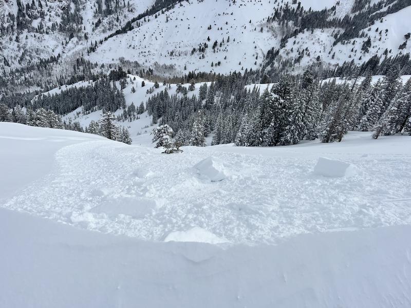
Notable avalanches were triggered in Maybird Aprons, Rocky Point, Park City Ridgeline, Mill B South, and Highline (See photo below), as well as multiple others with both skier-triggered and natural slides reported. Outside the forecast zone, a close call in the Terminal Cancer couloir in Lamoille Canyon (Ruby Range) offered some good takeaways.
Photo from the cornice triggered avalanche on Highline
Monday, March 17
Strong southwest winds transported snow across the mountains, forming fresh wind slabs and growing cornices. Gusts reached 80 mph on upper ridgelines, creating dangerous avalanche conditions.
Avalanche danger was CONSIDERABLE at upper elevations and on north- through east-facing mid-elevations, where human-triggered avalanches were likely. Warming temperatures contributed to wet snow instability, especially on sunlit slopes at lower and mid-elevations. A storm system moved in, bringing significant snowfall and further loading the snowpack.
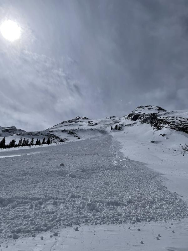
A few new wind slab avalanches, likely triggered by cornice falls, were reported in Upper Days Fork and Wolverine Cirque. Despite these releases, conditions were less active and more stubborn than the previous day. In Broads Fork, full-depth glide avalanches released on the steep quartzite slabs of Bonkers and the Diving Board.
Impressive glide avalanche - Diving Board
Tuesday, March 18
A strong storm moved in overnight, bringing heavy snowfall and a sharp temperature drop. Winds shifted to the northwest, easing from the intense southwesterly gusts but still blowing steadily along the ridgelines. By morning, 4–8 inches of new snow had already accumulated, with another foot or more expected by evening.
Avalanche danger increased throughout the day, reaching CONSIDERABLE at mid and upper elevations as wind-drifted snow piled up. These new and developing drifts were sensitive, especially on north- through south-facing slopes, while older wind slabs remained stubborn but still a concern. Storm slabs and loose snow avalanches were also a factor, particularly during periods of heavy snowfall.
Highway and patrol teams were busy managing near-continuous mitigation efforts. Natural avalanches ran during the heaviest snowfall, while strong west-northwest winds—gusting over 100 mph—kept snow moving. In the late afternoon, a slide below Mt. Superior trapped two vehicles in Little Cottonwood Canyon. Fortunately, there were no injuries, but the incident reinforced the extreme avalanche risk along the canyon road.
Wednesday, March 19
A classic Wasatch day—clear skies, deep powder, and cold temperatures made for excellent skiing. Most areas received 6–12 inches of light, dry snow overnight, bringing storm totals to around 30 inches in Little Cottonwood and 20 inches in Big Cottonwood. Winds were light to moderate out of the northwest, with temperatures staying in the single digits and low teens.
Despite great conditions, avalanche danger remained a concern. Upper elevations and north-to-south-facing mid-elevations were rated CONSIDERABLE, with human-triggered avalanches likely and some natural activity possible. Wind-drifted slabs had stabilized somewhat but remained buried under fresh snow, making them harder to detect.
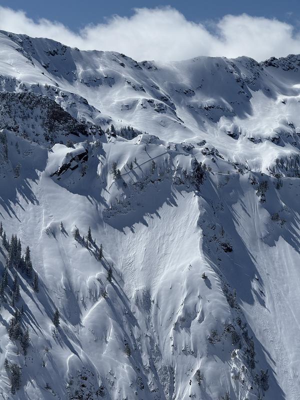
Natural avalanches occurred toward the end of the storm, including a fairly impressive avalanche on Santiago Ridge (photo below) but no new human-triggered avalanches were reported despite significant mountain activity.
Santiago Ridge Natural
Thursday, March 20
Avalanche danger dropped to MODERATE at upper elevations and on northwest- through east-facing mid-elevations, where wind-drifted slabs could still produce avalanches up to 1–3 feet deep. Sheltered areas had LOW danger.
Overnight, winds picked up and continued through the morning, with gusts over 40 mph on higher ridgelines, affecting exposed terrain. Despite this, good conditions were found on north-facing slopes, while south-facing aspects had a crust from the previous day's sun and warming. A minor cold front moved in, bringing some new snow and increasing cloud cover. Winds were an issue for most of the morning but were expected to shift and weaken by midday.


