March Kicks Off Our Spring Campaign- Donate Now to Support Forecasting

Forecast for the Moab Area Mountains

Eric Trenbeath
Issued by Eric Trenbeath on
Saturday morning, March 8, 2025
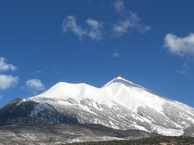
The avalanche danger is CONSIDERABLE on all steep, wind drifted slopes near and above treeline that face NW-N-NE-E. In these areas, thick slabs of wind drifted snow have formed over top of buried persistent weak layers, and deep and dangerous human triggered avalanches are likely. Below treeline on northerly aspects the danger is MODERATE where these types of avalanches are possible.
Increasing northeast winds today will create a MODERATE danger for human triggered avalanches involving fresh slabs of wind drifted snow. These will form in unusual places, particularly on south and west facing slopes. Be on the lookout for smooth rounded pillows of freshly deposited snow. Cracking is a sign of instability.
A MODERATE danger also exists for human triggered avalanches involving the most recent storm snow, particularly on sun exposed slopes where cold snow gets hit by the sun for the first time. Pay attention to how the recent snow is behaving before committing to steeper terrain.
Low
Moderate
Considerable
High
Extreme
Learn how to read the forecast here
Special Announcements
There won't be any construction on the loop road today and it will be open.
March kicks off our Spring Campaign! If everyone in Utah’s backcountry community donates the cost of something they regularly enjoy on an adventure—like a dawn patrol burrito, a backpack snack, or post-ride trailhead drinks—we could fund not just one but two forecasters for the entire season! Donate here. Thank you!
The Utah Avalanche Center is excited to host Mountainfilm on Tour in Moab at Star Hall on 3/21 and 3/22. Click here for tickets and information.
Geyser Pass Road: Grand County plowed yesterday!
Grooming Conditions: The Gold Basin trail was groomed yesterday.
Weather and Snow
6 A.M. Snow and Weather Data
24 Hour Snow: 4" 72 Hour Snow: 15" Season Total Snow: 97" Depth at Gold Basin: 53"
Winds on Pre-Laurel Peak: N/A Temp: 22° F Percent of Normal (SWE): 81%
Weather
Pre Laurel Peak wind station and the Gold Basin storm stake are down as we install upgrades including a web cam to the site.
4 inches of new snow stacked up yesterday bringing our storm total up to 15 inches at Gold Basin with up to 18 inches up high. Northerly winds were light yesterday but unfortunately, they started to ramp up overnight shifting to northeasterly. They'll continue to be a pain today blowing in the 20-30 mph range along ridge tops. Skies will be sunny, and high temperatures will creep up to around 30°F. Temperatures rise about 10 degrees on Sunday and Monday as short lived high pressure builds over the region. A weak system sliding by to the south brings clouds and a chance of snow on Tuesday, with a better looking storm by late next week.
General Conditions
It was as good as it gets up there yesterday with 15 inches of right side up, low density powder. Cloud cover and off and on snowfall kept conditions dry for most of the day but the sun made a brief appearance in the late afternoon and we noticed the snow surface getting slightly damp on a sunny aspect. The new snow was very well behaved and we did not find a storm slab out there but things may get active when the sun hits it for the first time, especially on southerly aspects where slick, hard surfaces lie underneath. In addition, increasing northeasterly winds today will likely deposit fresh slabs of wind drifted snow on to south and west aspects.
Early in the storm, strong south through southwest winds drifted snow on to northerly aspects adding stress to buried weak layers and in our travels yesterday we observed a few isolated collapses. Sam Van Wetter made a similar observation. This indicates that the recent snow load has increased the likelihood for triggering a deep avalanche on a persistent weak layer, particularly on slopes that face NW-N-E.
So good to see the peaks looking white!
Snowpack and Weather Data
Gold Basin SNOTEL site (10,000')
SNOTEL site near Geyser Pass Winter Trailhead (9600')
Wind Station on Pre-Laurel Peak (11,400')
NWS forecast for the La Sal Mountains.
Recent Avalanches
Ad
Avalanche Problem #1
Persistent Weak Layer
Type
Location
Likelihood
Size
Description
Isolated collapsing yesterday indicates that the recent snow load has begun to stress persistent weak layers buried deep in the snowpack. The snowpack structure is poor with a dense hard slab 2-3 feet thick on top of multiple layers of weak, sugary, faceted snow. Stability tests remain reactive but stubborn. Nevertheless, any avalanche triggered would be deep, dangerous, and possibly un-survivable. The danger is greatest on steep slopes near and above treeline where strong, southwest winds have deposited thick slabs on top of these weak layers and this type of terrain should be avoided. Northerly aspects below treeline also remain suspect with equally poor structure. The main difference is a lack of recent wind loading. In these areas, deep, human triggered avalanches remain possible.
Avalanche Problem #2
Wind Drifted Snow
Type
Location
Likelihood
Size
Description
Increasing northeast winds today will deposit snow in unusual places, particulary on south and westerly aspects. Be on the lookout for fresh slabs of wind drifted snow to form on the leeward sides of ridge crests and terrain features in exposed terrain. Wind slabs are often recognizable by their smooth, rounded appearance and cracking is a sign of instability.
Deep drifts that formed during the storm on northerly aspects will be less sensitive today but the primary concern there is the additioanl stress they have placed on buried persistent, weak layers. Steep, wind drifted slopes on the north side of the compass should be avoided.
Avalanche Problem #3
New Snow
Type
Location
Likelihood
Size
Description
In our travels yesterday, we found the recent storm snow to be quite well behaved and we did not observe any slab. 15 inches is a lot of new snow however, and it may undergo some changes today with wind and sun. It may thicken into a denser slab in some areas, and become reactive the first time the sun hits it, particularly on southerly aspects where slick hard surfaces exist underneath. Pay attention to how it is behaving before committing to steeper terrain. Look for cracking or slab formation, or loose snow sluffs as the day heats up.
Additional Information
Check out the latest UAC podcast with forecaster Brett "Kowboy" Kobernick where he discusses faceted persistent weak layers and how "nobody is immune from getting killed in an avalanche."
Sign up for text alerts to get the most up to date information about changing conditions, road plowing, special avalanche announcements.
Follow us on Instagram @utavy_moab
General Announcements
This forecast is from the U.S.D.A. Forest Service, which is solely responsible for its content. This forecast describes general avalanche conditions and local variations always occur.