March Kicks Off Our Spring Campaign- Donate Now to Support Forecasting

Forecast for the Moab Area Mountains

Eric Trenbeath
Issued by Eric Trenbeath on
Sunday morning, March 9, 2025
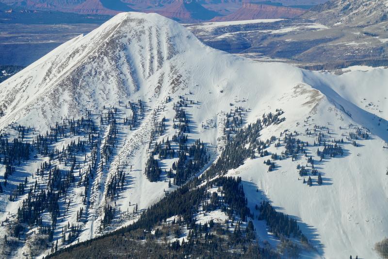
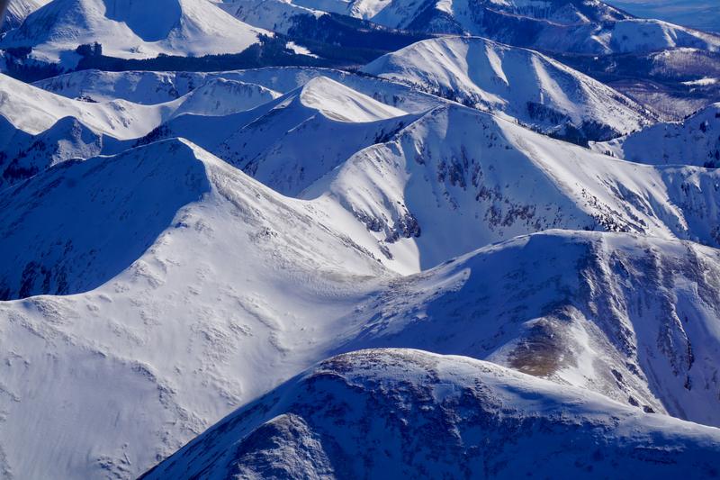
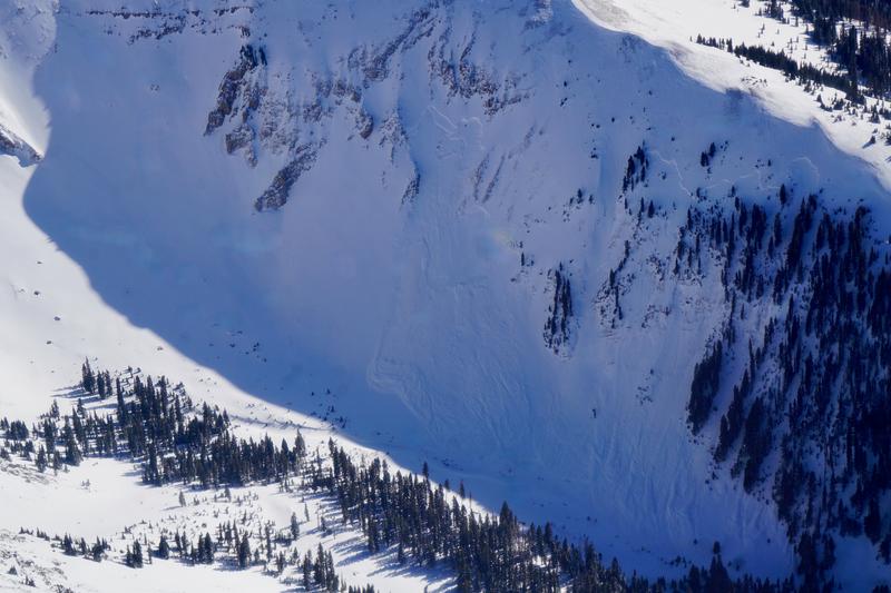
The avalanche danger remains CONSIDERABLE on all steep, wind drifted slopes near and above treeline that face NW-N-NE-E. In these areas, thick slabs of wind drifted snow have formed over top of buried persistent weak layers, and deep and dangerous human triggered avalanches are likely. Below treeline on northerly aspects the danger is MODERATE and deep and dangerous avalanches are possible.

A strong sun and very warm temperatures today will create a MODERATE danger for loose, wet avalanches on sun exposed slopes. The danger follows the sun with east facing slopes affected first and westerly aspects getting hit later in the day. Signs of instabiity include roller balls, pinwheels, and sloppy wet snow. Stay off of, and out from under steep slopes as they become wet and sloppy.

An isolated, or MODERATE danger exists for human triggered avalanches involving slabs of wind drifted snow. Fresh wind slabs may be found on all aspects, primarily above treeline in wind exposed terrain.
Low
Moderate
Considerable
High
Extreme
Learn how to read the forecast here
Special Announcements
We come to you with heavy hearts and great sadness this morning to confirm an avalanche accident on Friday, March 7th near Hoyt Peak, involving 51 year old Micheal Janulaitis from Marion, Utah. Micheal used a snowbike to access the terrain, but was caught, carried, and killed in an avalanche while skiing a steep, northeast facing run on Hoyt Peak.
Huge thanks to the Department of Public Safety, Park City Mountain Resort and Canyons Village Snow Safety and Ski Patrol teams, along with Wasatch Backcountry Rescue for the hard work recovering Micheal and returning him to his family. Micheal was a friend of Utah Avy and we feel privileged for the time we got to spend together. This is a tremendous loss for our backcountry family and we will miss him deeply. We are compiling accident details and a preliminary report is available here.
March kicks off our Spring Campaign! If everyone in Utah’s backcountry community donates the cost of something they regularly enjoy on an adventure—like a dawn patrol burrito, a backpack snack, or post-ride trailhead drinks—we could fund not just one but two forecasters for the entire season! Donate here. Thank you!
The Utah Avalanche Center is excited to host Mountainfilm on Tour in Moab at Star Hall on 3/21 and 3/22. Click here for tickets and information.
Geyser Pass Road: The road is plowed and is mostly down to the dirt.
Grooming Conditions: The Gold Basin trail was last groomed on Friday.
Weather and Snow
6 A.M. Snow and Weather Data
24 Hour Snow: 0" 72 Hour Snow: 15" Season Total Snow: 97" Depth at Gold Basin: 46"
Winds on Pre-Laurel Peak: N/A Temp: 15° F Percent of Normal (SWE): 87%
Weather
Pre Laurel Peak wind station and the Gold Basin storm stake are down as we install upgrades including a web cam to the site.
Northeast winds that raked through the high country yesterday have backed off and begun a gradual shift to the west southwest. Today looks to be sunny, warm, and calm with high temperatures soaring up to around 40°F at 10,000'. More of the same is on tap for tomorrow. Temperatures remain 5-10 degrees above average through mid-week. A weak storm system tracking by to the south will bring a few clouds and breezy conditions on Tuesday, while a better looking system is shaping up for later in the week. Stay tuned.
General Conditions
The wind bringeth, the wind taketh away...Friday's powder party took a hit yesterday from the wind and sun, but folks were out in force enjoying the sunshine and still finding soft snow on sheltered slopes. We received several excellent observations over the last couple of days including reports of recent natural avalanches. All said and done, the mountains received up to two feet of snow last week with 15-18 inches falling Thursday and Friday. The storm began with strong southwest winds and ended with strong winds from the northeast with a blessed lull in the middle. Needless to say, alternating drifting and scouring has occurred on all aspects near and above treeline. The deepest and scariest drifts lie on northerly facing slopes where thick hard slabs have formed over weak layers of faceted snow. The recent snowload has brought fresh life to our persistent weak layer problem as the recent avalanche activity makes clear. Additionally, collapsing and whumphing are being observed, and although not widespread, it is sometimes occurring after multiple trips up the same skin track (see Nate Ament observation). This is a very scary situation, and a clear sign that the snowpack is not to be trusted.
Chris Benson took to the skies yesterday and submitted these photos of the high country where you can clearly see alternating scouring and loading that occured on all aspects above treeline.
Southeast facing Mount Tukuhnikivatz. Note the wind rippled areas of drifted snow adjacent to scoured surfaces.
Northerly aspects in the north group.
Snowpack and Weather Data
Gold Basin SNOTEL site (10,000')
SNOTEL site near Geyser Pass Winter Trailhead (9600')
Wind Station on Pre-Laurel Peak (11,400')
NWS forecast for the La Sal Mountains.
Recent Avalanches
A handful of recent natural avalanches have been reported over the past couple of days including this large slide in Horse Creek reported by Travis Nauman, with an aerial photo below courtesy of Chris Benson. This avalanche is noteworthy as it occurred on bullseye, near treeline terrain where the persistent weak layer is most consistently widespread with a well connnected slab over it.
See the complete avalanche database here.
Ad
Avalanche Problem #1
Persistent Weak Layer
Type
Location
Likelihood
Size
Description
Natural avalanche activity and collapsing of the snowpack are clear indicators that our persistent weak layer remains a serious problem to contend with. The snowpack structure is poor with a dense hard slab 2-3 feet thick on top of multiple layers of weak, sugary, faceted snow. Stability tests remain reactive but stubborn, and collapsing isn't widespread, but this just means you don't know if and when a particular slope is going to release. It could occurr after multiple laps, and any avalanche triggered would be deep, dangerous, and possibly un-survivable. The danger is greatest on steep northerly aspects near treeline where strong southwest winds have deposited thick slabs on top of these weak layers and this type of terrain should be avoided. Northerly aspects below treeline also remain suspect with equally poor structure. The main difference is a lack of recent wind loading. In these areas, deep, human triggered avalanches remain possible.
Brian Sparks dug down in the snow over near South Mountain yesterday. See his thoughts on the persistent weak layer problem here.
Dave and I dug into the snow on a NE aspect around 11,000' on Friday where we got a stubborn, but classic "cash register" release on depth hoar at the base of the snowpack.
Avalanche Problem #2
Wet Snow
Type
Location
Likelihood
Size
Description
A strong sun and very warm temperatures today will bring on a rising danger for loose, wet avalanches on sun exposed slopes. The danger follows the sun with east facing slopes affected first and westerly aspects getting hit later in the day. Signs of instabiity include roller balls, pinwheels, and sloppy wet snow up arond your boot tops. Stay off of, and out from under steep slopes as they become wet and sloppy.
Avalanche Problem #3
Wind Drifted Snow
Type
Location
Likelihood
Size
Description
Isolated areas of wind drifted snow may remain a problem today. Look for them on all aspects on the leeward sides of ridge crests and terrain features such as gully walls and subridges, primarily in upper eleveation, wind exposed terrain. Crossloading is a factor and in some areas they may exist next to scoured surfaces. Wind slabs are often recognizable by their smooth, rounded appearance and they may sound or feel hollow underneath. Cracking is a sign of instability.
Additional Information
Check out the latest UAC podcast with forecaster Brett "Kowboy" Kobernick where he discusses faceted persistent weak layers and how "nobody is immune from getting killed in an avalanche."
Sign up for text alerts to get the most up to date information about changing conditions, road plowing, special avalanche announcements.
Follow us on Instagram @utavy_moab
General Announcements
This forecast is from the U.S.D.A. Forest Service, which is solely responsible for its content. This forecast describes general avalanche conditions and local variations always occur.