

Nikki Champion
Forecaster
Week in Review: Avalanche Conditions and Snowpack Developments (January 31 - February 6, 2025)
Each week, we look back at the key snowfall, weather, and avalanche events from the previous week. For archived forecasts, visit the Salt Lake Mountains’ past updates.
Overall Summary:
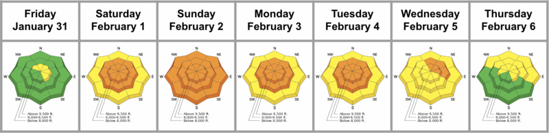
A powerful winter storm brought heavy snow, strong winds, and rapidly changing avalanche conditions beginning Saturday, February 1. The week began with MODERATE danger but quickly escalated to CONSIDERABLE as 7-12 inches of snow and 70+ mph winds created reactive wind slabs on weak, faceted snow. Multiple large avalanches were reported, including deep slides in Mineral Fork and Deer Valley. By Sunday, storm totals reached nearly two feet in some regions, with rain up to 8,000 feet. Human-triggered avalanches were likely, and cornices became increasingly unstable. Tragically, one avalanche fatality occurred in the Monte Cristo area.
A powerful winter storm brought heavy snow, strong winds, and rapidly changing avalanche conditions beginning Saturday, February 1. The week began with MODERATE danger but quickly escalated to CONSIDERABLE as 7-12 inches of snow and 70+ mph winds created reactive wind slabs on weak, faceted snow. Multiple large avalanches were reported, including deep slides in Mineral Fork and Deer Valley. By Sunday, storm totals reached nearly two feet in some regions, with rain up to 8,000 feet. Human-triggered avalanches were likely, and cornices became increasingly unstable. Tragically, one avalanche fatality occurred in the Monte Cristo area.
Warm temperatures and continued wind-loading kept avalanche danger elevated through midweek. Wet snow became a concern on lower and even mid-elevations. By Thursday, the danger dropped to MODERATE, with wind slabs and a persistent weak layer the remaining concerns.
Friday, January 31
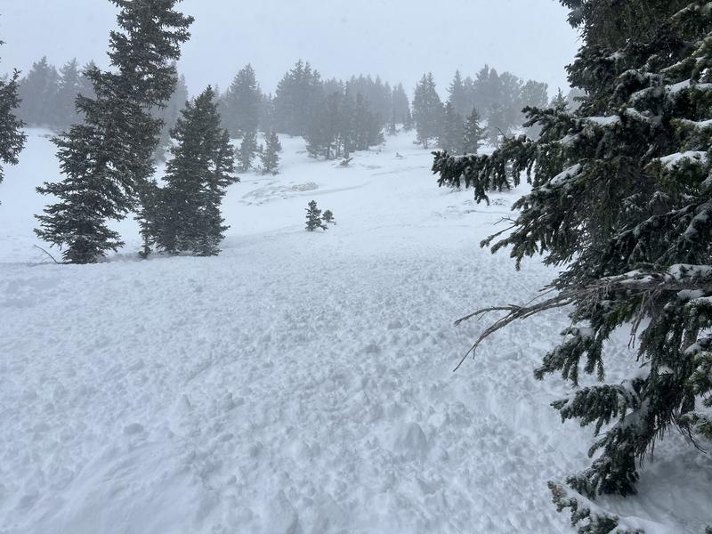
It was a calm morning in the mountains, but conditions changed quickly throughout the day. Winds picked up, forming fresh wind-drifted snow on upper-elevation slopes, increasing the avalanche danger to MODERATE. These drifts sat on weak, faceted snow, making them sensitive to human triggers. A Winter Storm Watch was issued for Northern Utah and Southeast Idaho as a major winter storm approached, expected to bring 1-2 feet of snow and strong winds through the weekend.
It was a calm morning in the mountains, but conditions changed quickly throughout the day. Winds picked up, forming fresh wind-drifted snow on upper-elevation slopes, increasing the avalanche danger to MODERATE. These drifts sat on weak, faceted snow, making them sensitive to human triggers. A Winter Storm Watch was issued for Northern Utah and Southeast Idaho as a major winter storm approached, expected to bring 1-2 feet of snow and strong winds through the weekend.
Saturday, February 1
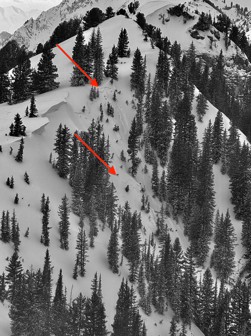
Stormy conditions continued with 7-12 inches of snow and strong southwest winds gusting up to 70 mph. The avalanche danger rose to CONSIDERABLE, with human-triggered avalanches likely, especially at mid and upper elevations. The new snow didn’t bond well to the weak, faceted layer below, and wind-loading created reactive slabs on leeward slopes. A Winter Storm Warning remained in effect. Several slides were reported, including:
Stormy conditions continued with 7-12 inches of snow and strong southwest winds gusting up to 70 mph. The avalanche danger rose to CONSIDERABLE, with human-triggered avalanches likely, especially at mid and upper elevations. The new snow didn’t bond well to the weak, faceted layer below, and wind-loading created reactive slabs on leeward slopes. A Winter Storm Warning remained in effect. Several slides were reported, including:
- East Bowl (west aspect at 10,100’) – new snow avalanche failing on the old/new interface.
- Maybird (northeast aspect at 9,800’) – new snow avalanche failing on the new/old interface.
East Bowl Avalanche - W Aspect -10,100' - BG
Sunday, February 2
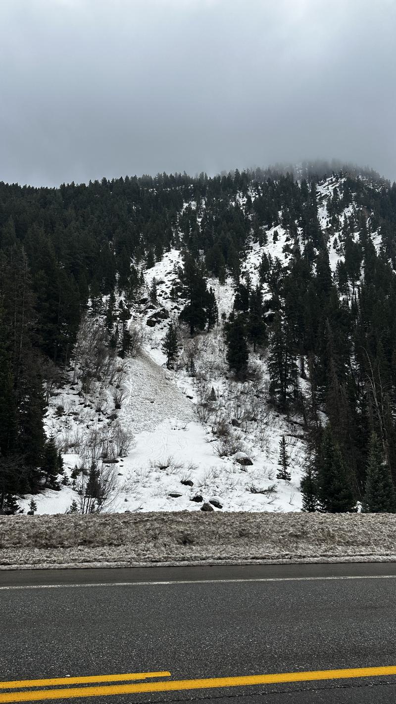
With 7-12 inches of new snow and .75-1.50 inches of water, conditions remained unstable. Warm temperatures and rain up to 8,000 feet added an issue of wet avalanches at lower elevations. The avalanche danger was CONSIDERABLE at all elevations, with wind-drifted slabs and a persistent weak layer creating concerns. Wet snow avalanches also became possible. Winds gusted over 100 mph at the highest ridges, forming fresh, reactive drifts. Travel in avalanche terrain was not recommended, and 14 avalanches were reported on Sunday, most triggered by cornice falls. I recommend checking out all the avalanches from the 2nd, it's an impressive list.
With 7-12 inches of new snow and .75-1.50 inches of water, conditions remained unstable. Warm temperatures and rain up to 8,000 feet added an issue of wet avalanches at lower elevations. The avalanche danger was CONSIDERABLE at all elevations, with wind-drifted slabs and a persistent weak layer creating concerns. Wet snow avalanches also became possible. Winds gusted over 100 mph at the highest ridges, forming fresh, reactive drifts. Travel in avalanche terrain was not recommended, and 14 avalanches were reported on Sunday, most triggered by cornice falls. I recommend checking out all the avalanches from the 2nd, it's an impressive list.
Davenport Hill Avalanche - Similar crown to the fatality 12/31 - NE Aspect - 9900' - Kelly
Monday, February 3
It was a warm, windy, and active day in the Salt Lake mountains. The avalanche danger remained CONSIDERABLE at mid and upper elevations, with weak, faceted snow buried under new snow and wind-drifted slabs, making human-triggered avalanches likely. Intense winds formed dangerous cornices and drifting snow further downslope. Wet snow avalanches were also a concern, with temperatures climbing into the upper 40s°F.
It was a warm, windy, and active day in the Salt Lake mountains. The avalanche danger remained CONSIDERABLE at mid and upper elevations, with weak, faceted snow buried under new snow and wind-drifted slabs, making human-triggered avalanches likely. Intense winds formed dangerous cornices and drifting snow further downslope. Wet snow avalanches were also a concern, with temperatures climbing into the upper 40s°F.
A 37-year-old male from Evanston, Wyoming was caught, carried, fully buried, and killed in an avalanche while snowmobiling in the Whiskey Hill - Beer Hill area of Curtis Creek, east of Huntsville, Utah. The partner was unable to locate the buried person, and a 911 call was made. The initial accident report is available HERE.
Tuesday, February 4
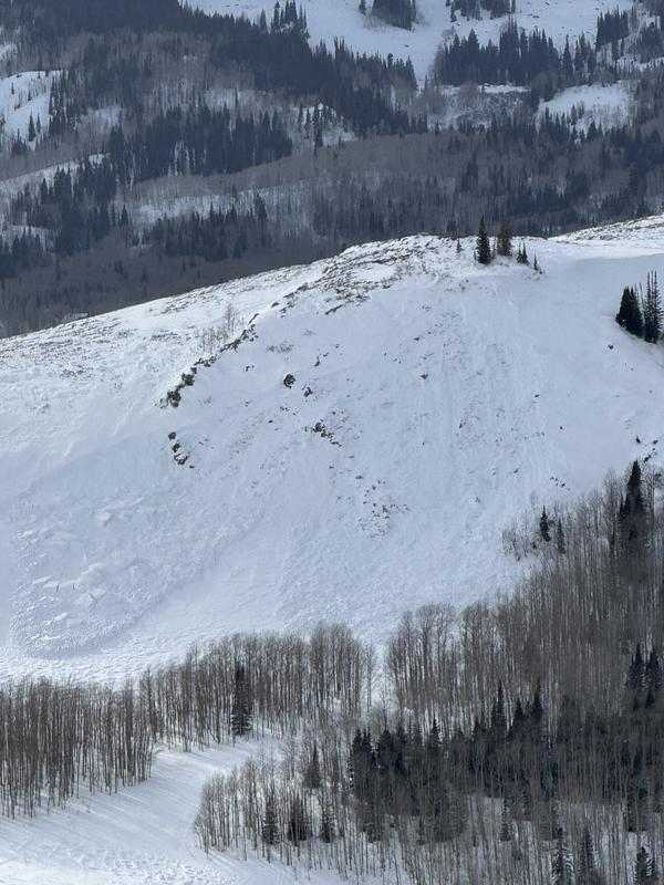
Conditions remained warm and windy, with CONSIDERABLE avalanche danger at mid and upper elevations. Wind-drifted slabs were still a concern, and several slides were reported, including:
Conditions remained warm and windy, with CONSIDERABLE avalanche danger at mid and upper elevations. Wind-drifted slabs were still a concern, and several slides were reported, including:
- A 2-3' deep hard slab at Deer Valley, 450’ wide, failing on old faceted grains on an east-facing slope at 9,000’.
- A remote cornice-triggered avalanche in upper BCC near Lane’s Leap, north-facing at 9,600’, triggered a repeater pocket to the ground.
Impressive Natural hard slab outside Deer Valley - 450' wide - Caruso
Wednesday, February 5
It was a windy, unsettled day in the Salt Lake mountains, and the avalanche danger remained CONSIDERABLE at mid and upper elevations. The strong winds formed wind-drifted slabs, making human-triggered avalanches up to 1-3 feet deep likely. At lower and mid-elevations, wet snow avalanches remained a concern due to the ongoing warm temperatures, including Argenta Chutes in mid-Big Cottonwood Canyon.
It was a windy, unsettled day in the Salt Lake mountains, and the avalanche danger remained CONSIDERABLE at mid and upper elevations. The strong winds formed wind-drifted slabs, making human-triggered avalanches up to 1-3 feet deep likely. At lower and mid-elevations, wet snow avalanches remained a concern due to the ongoing warm temperatures, including Argenta Chutes in mid-Big Cottonwood Canyon.
Natural Wet Slab - Argenta Chutes - NE Aspect - 8400' - Photo: B
Thursday, February 6
It was another windy morning in the Salt Lake mountains, with a MODERATE avalanche danger. Wind slabs lingered on north to east-facing slopes at mid and upper elevations, and cornices continued to become unstable. Persistent weak layers remained a concern. Wet snow concerns at lower elevations were subsiding, but the snow was still slow to refreeze. A storm moving in is to bring more precipitation to the mountains, especially to upper Big Cottonwood and the south Park City ridgeline, with 6-12 inches expected by Saturday morning.
It was another windy morning in the Salt Lake mountains, with a MODERATE avalanche danger. Wind slabs lingered on north to east-facing slopes at mid and upper elevations, and cornices continued to become unstable. Persistent weak layers remained a concern. Wet snow concerns at lower elevations were subsiding, but the snow was still slow to refreeze. A storm moving in is to bring more precipitation to the mountains, especially to upper Big Cottonwood and the south Park City ridgeline, with 6-12 inches expected by Saturday morning.


