AVALANCHE WARNING!! Tap for info

Forecast for the Provo Area Mountains

Dave Kelly
Issued by Dave Kelly on
Saturday morning, February 1, 2025
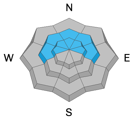
Today, the avalanche danger is CONSIDERABLE at all aspects and elevations for the Provo Area Mountains. It will be possible for humans to trigger an avalanche 1'-3' deep, failing on buried facets near the ground. This is more likely in shallow thin rocky zones or in repeater avalanche paths.
Expect to see, and look to avoid loose new snow, soft slab and wind-drifted snow avalanches.
Any rain on snow is suspect particularly when facets are involved. Pay particular attention if you're ice climbing as avalanches that start as dry snow could turn into wet slides very quickly when confined to steep gully features.
Low
Moderate
Considerable
High
Extreme
Learn how to read the forecast here
Avalanche Watch
What: Heavy snowfall and wind drifting will elevate the backcountry avalanche danger over the weekend. Very dangerous conditions and HIGH avalanche danger are expected to develop in many areas
When: The watch is in effect from 6am MST this morning to 6am MST Sunday.
Where: For the mountains of Northern Utah, including the Wasatch Range and Uinta Mountains. An Avalanche Warning has been issued for the mountains of Northern Utah and Southeast Idaho, including the Bear River Range.
Impacts: This weekend, heavy snow and strong winds will elevate the avalanche danger. Human-triggered and natural avalanches are likely. People should avoid travel in backcountry avalanche terrain and avoid avalanche runouts. Stay off of and out from underneath slopes steeper than 30°.
Weather and Snow
Currently, under overcast skies trailhead temperatures are in the low 30's °F and the highest peaks are in the mid teen's °F. Wind speeds are blowing from the southwest in the 20's gusting to the 30's. Mountain weather stations report rain at lower elevations with 1"-2" snow and .10"-.20" water overnight.
Today, a fire hose of a storm lines up on Northern Utah. We can expect to see temperatures 30-36 °F and rising this afternoon. Trailhead winds will blow from the west 15 gusting to 20, and at the highest peaks 30 gusting to 40 with gusts to the high 50's MPH and rising wind speeds this afternoon. 4"-6" of snow is forecast with .50"-1.25" water and the possibility of rain in the lower elevation terrain.
Our partners at the National Weather Service have issued a Winter Storm Warning, effective until Sunday at 5PM.
Recent Avalanches
There were no reports of avalanche activity from the backcountry yesterday. Read all observations HERE.
Ad
Avalanche Problem #1
New Snow
Type
Location
Likelihood
Size
Description
Heavy dense new snow is falling onto a weak layer of faceted old snow. Expect to see loose new snow avalanches at all aspects and elevations and shallow soft slab avalanches in higher elevation terrain. Any slope over 30° is suspect. Stay off of and out from underneath slopes greater than 30° particularly during periods of increased snowfall rates.
With rising temperatures this afternoon, these new snow avalanches could be either wet or dry. Any rain on snow, particularly rain on buried facets is suspect and if it does turn to rain then avoid traveling on or under any steep terrain.
Avalanche Problem #2
Wind Drifted Snow
Type
Location
Likelihood
Size
Description
Strong winds have drifted the new snow into wind drifts that now sit on top of an old weak sugary faceted snow surface. These drifts will not bond well to the old snow surface. Look for and avoid pillowy, rounded new wind drifts. Shooting cracks, cornices, and collapsing are all signs of wind-drifted snow and these are areas to avoid. With increasing wind speeds throughout the day drifts may appear lower on the slope and further down ridgelines.
Avalanche Problem #3
Persistent Weak Layer
Type
Location
Likelihood
Size
Description
There are currently two buried weak layers in our snowpack. One is a layer of buried near-surface facets that formed during last week's cold clear weather. This layer will not bond well to the newest snow and expect to see sloughing and loose dry avalanches on this layer.
The second layer is buried near the ground. This layer was formed in December and was responsible for many large avalanches during the Holiday Avalanche Cycle. This layer will be more likely to be triggered as the storm continues and we could see avalanches 1'-3' deep. The most likely places to trigger an avalanche on this layer of buried facets are steep slopes that have a thinner snowpack, rocky gully features, and areas that previously avalanched. The UAC forecasters went to look at an avalanche that was a wind-drifted snow avalanche that failed on facets near the ground and was likely a repeater last week. Read their observation HERE.
Read more about persistent weak layer avalanches HERE.
General Announcements
This information does not apply to developed ski areas or highways where avalanche control is normally done. This forecast is from the U.S.D.A. Forest Service, which is solely responsible for its content. This forecast describes general avalanche conditions and local variations always occur.