AVALANCHE WARNING!! Tap for info

Forecast for the Provo Area Mountains

Greg Gagne
Issued by Greg Gagne on
Friday morning, January 31, 2025
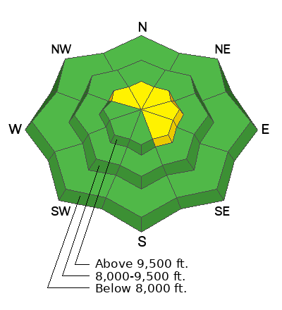
The avalanche danger will rise to MODERATE on upper-elevation slopes as increasing winds will create sensitive soft slabs of wind-drifted snow on aspects facing northwest, through east, and southeast.

The avalanche danger is expected to rise by Saturday, with heavy snowfall and strong winds forecast for this weekend.
Low
Moderate
Considerable
High
Extreme
Learn how to read the forecast here
Special Announcements
Check out this insightful blog by Paige and Jeremy where they break down the complexities of Persistent Weak Layer (PWL) avalanches, why thin and rocky areas are especially dangerous, and how to manage the risks effectively in the backcountry.
Weather and Snow
This Morning: Skies are clear and temperatures are in the mid 20's F with light winds from the west, gusting into the teens along exposed ridgelines and peaks through the mid-elevations and 20's mph at 11,000'.
Today: Skies will cloud up this afternoon with temperatures rising into the low and mid 30's F. Winds will be from the west/southwest and increasing throughout the day, gusting to near 30 mph through 10,500' and near 50 mph at 11,000'
This Weekend: The National Weather Service has issued a Winter Storm Warning for the mountains of northern Utah, with heavy snow expected to develop overnight and into Saturday, lasting through at least Monday. Rising temperatures with more than 1 foot of heavy, dense snow accompanied by strong winds are possible by Sunday.
Recent Avalanches
No backccountry avalanches were reported on Thursday.
Find all avalanches from the past few days on the observations and avalanche page.
Ad
Avalanche Problem #1
Wind Drifted Snow
Type
Location
Likelihood
Size
Description
Increasing winds from the west will create fresh wind drifts at the upper elevations. Wind drifts may be sensitive as they will form on top of weak, faceted snow at the surface of the snowpack on slopes facing north through east and southeast.

On Thursday, Mark Johnston and I were finding widespread weak snow at the surface of many slopes. This is likely going to be a weak layer with any fresh wind drifts and storm snow. I describe what we saw in this video:
General Announcements
This information does not apply to developed ski areas or highways where avalanche control is normally done. This forecast is from the U.S.D.A. Forest Service, which is solely responsible for its content. This forecast describes general avalanche conditions and local variations always occur.